


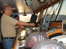
Second captain Lambros Katsenis navigates the research vessel (R/V) Aegaeo. Navigation is an important part of deep-sea science. The R/V Aegaeo is equipped with a satellite-based differential global positioning system (DGPS) that determines its location on Earth. GPS does not work underwater so scientists and technicians must use other methods to determine underwater location. Click image for larger view and image credit.
Where Are We?
June 30, 2006
36 N, 25 E
Brian Bingham
Professor
Olin College
One of my colleagues likes to say, "Start by figuring out where you are." Navigation is the art and science of determining where you are; it is an important part of deep-sea science and exploration. Dr. Richard Camilli invents amazing new devices for "sniffing" out chemical traces, making it possible to see into a world previously unexplored. Knowing where the sensor is — putting his measurements onto a map of the sea floor — transforms experiments into systematic scientific exploration.
My job during this cruise on the R/V Aegaeo is to help determine where "we" are. When we arrive on station, I work with the ship to deploy transponders — small automatic acoustic elements that serve as beacons. By knowing where these transponders are, we can use geometry to determine our location. This is very similar to the way a global positioning system (GPS) works, but unfortunately GPS does not work in seawater. (The electromagnetic waves that carry the GPS signal only travel about 1 mm below the surface). Once our transponders are anchored on the sea floor, we are ready to deploy a vehicle: the Thetis submersible, the remotely operated vehicle (ROV) Achilles or the autonomous underwater vehicle (AUV) SeaBED (or maybe even more than one!). While we are exploring the sea floor these transponders constantly report our position relative to the fixed points. This information is accompanied by a Doppler velocity log (DVL) — a sort of underwater speedometer. If we keep track of our speed, our heading, and our transponder messages, we can methodically and systematically survey the sea floor — creating detailed maps of our sensor data. The quality of this map is directly related to how well we know our position. When it is all over and time to move to the next stop, we must collect these transponders. The transponders respond to a particular message, floating back to the surface for collection.
Navigation is one of the underlying technologies making possible all of what we do in exploring and understanding our oceans. The methods and instruments we use are constantly getting better, but it still takes patience and expertise to know precisely where you are. Just like the ancient mariners, relying on the location of the stars and environmental clues (cloud types, wave shape, and seabird presence), we use everything at our disposal to get better and better at knowing where we are.
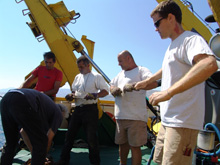
Professor Brian Bingham (front) works with research vessel Aegaeo crew to deploy a transponder off the aft deck of the ship. By knowing where these transponders are, the team can use geometry to determine the location of an underwater vehicle. Click image for larger view and image credit.
Underwater Navigation Methods
Dr. Ryan Eustice
Assistant Professor
University of Michigan
Since GPS does not work underwater, due to the attenuation of radio waves through the medium of water, engineers must resort to alternative methods for navigating the vehicles that we deploy. One standard method for navigation mentioned above has been the use of acoustic long-baseline navigation (LBL) — a technique developed in the early 1970s. LBL involves mooring acoustic transponder beacons on the sea floor, allowing each vehicle in the water to measure the round-trip travel time of sound signals transmitted and received between it and each beacon. With two or more beacons plus a measurement of vehicle depth, the vehicle's position can be accurately computed. The major disadvantage of LBL, however, is that it takes time to deploy and calibrate the beacon network. Moreover, as the number of vehicles in the LBL network increases, the frequency with which each vehicle can communicate with the network decreases, meaning that LBL is only practical for a few vehicles at most. An additional limitation is that each beacon has a finite working range within which the vehicles can acoustically hear it; this limits the effective working range of the beacon network to one or two water depths.
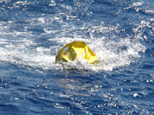
A transponder is deployed! Once the transponders are anchored on the sea floor, the team deploys the vehicles. While we are exploring the sea floor with underwater vehicles, these transponders constantly report our position relative to the fixed points. This information is merged with a mix of sensors, enabling us to methodically and systematically survey the sea floor, and to create detailed maps of our sensor data. This will allow future scientists to document changes to the site over time. Click image for larger view and image credit.
Sign up for the Ocean Explorer E-mail Update List.