


The route of HMS Challenger. The expedition lasted 1,000 days and covered more than 68,000 nautical miles. Click image for larger view.
Then and Now: The HMS Challenger Expedition and the “Mountains in the Sea” Expedition
Dr. Tina Bishop, Peter Tuddenham and Melissa Ryan
The College of Exploration ![]()
Diana Payne, Connecticut Sea Grant
Ivar Babb, University of Connecticut’s National Undersea Research Center
Scientific ocean exploration began in the 19th century, using wooden sailing ships. At that time, explorers had none of the technological sophistication and tools available today. A comparison of modern-day exploration with the late 19-century journey of the HMS Challenger illustrates the progress that science has made in ocean exploration.
The HMS Challenger Expedition
The 1870s voyage of HMS Challenger lasted 1,000 days and covered more than 68,000 nautical miles. Many consider it to be the first true oceanographic expedition because it yielded a wealth of information about the marine environment. Those aboard identified many organisms then new to science, and they gathered data at 362 oceanographic stations on temperature, currents, water chemistry, and ocean floor deposits. The scientific results of the voyage were published in a 50-volume, 29,500-page report that took 23 years to compile. Specialists in numerous scientific disciplines studied the collections and data, and helped produce the reports. Also, the reports written by members of the Challenger expedition provided rich descriptions of the flora, fauna and cultures of the lands visited. Photography—new at the time—was highlighted as well, along with scientific illustration.
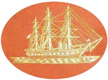
A representation of the HMS Challenger. Although the former warship had a steam engine, its sails were used most often during the expedition to allow for frequent stops. Click image for larger view.
The HMS Challenger originally was designed as a British warship—a steam corvette in the Royal Navy—outfitted with 17 guns and an engine capable of over 1,200 horsepower. The 200-foot ship was three-masted, square-rigged, and built of wood.
In 1870, Dr. C. Wyville Thomson suggested that the Royal Society of London ask the British government for the use of one of its ships for an extended research cruise. The government agreed, and the HMS Challenger was modified to conduct oceanic research. Ammunition and 15 of the guns were removed from the ship and replaced with laboratories, workrooms, and storage space. The HMS Challenger used sails rather than the steam engine most of the time to allow for frequent stops when collecting data. The steam engine was used only during dredging operations to collect samples from the depths of the ocean floor.
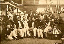
The science and ship crew of the HMS Challenger in 1874. The original crew of 216 had dwindled to 144 by the end of the long expedition. Click image for larger view.
The science and ship crew consisted of six civilian/scientific staff, led by Dr. C. Wyville Thomson. It also included 21 naval officers, including Captain George Nares (replaced by Captain Frank Thomson in 1875), and approximately 216 crew. When the voyage ended in 1876, only 144 crew remained on the ship. Seven people had died, five left when Captain Nares did, 26 were left in hospitals or were unable to continue the journey, and several had deserted at the various ports of call.
HMS Challenger and the “Mountains in the Sea” Expedition
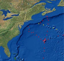
Map of the North Atlantic showing HMS Challenger sampling sites (red) and the dive sites of the Mountains in the Sea research cruise (yellow). (GIS provided by I. Babb, NURC). Click image for larger view.
The Mountains in the Sea Expedition will focus on the biodiversity of the New England seamount chain. The cruise path will cross some of the same area traversed by the HMS Challenger more than 100 years ago. Several of the HMS Challenger sampling sites are in the same area as the seamounts we plan to explore in this expedition—Bear, Kelvin and Manning.
Our proposed dive sites are shown in yellow on the figure at the left. Note on the figure that two of the sites (Bear seamount, which is the northwesternmost yellow dot, and the HMS Challenger site explored on May 6, 1873, which is the closest red dot to Bear seamount) are not far apart. The Mountains in the Sea project will use multibeam mapping, dredge sampling, and observation and collection techniques using the Alvin submersible to explore the seamounts. We will compare these techniques and results to methods used by the HMS Challenger.
The Ships: Then and Now
Although the overall deck plan, maneuverability and engine power of the vessels are very different, similar challenges remain in conducting oceanographic research. Dive plans and research objectives must change quickly when inclement weather arises. Lost research opportunities, broken gear and seasickness are still a part of modern day research cruises.
Scientific Instruments: Then and Now
The HMS Challenger crew faced many challenges when they tried to determine temperature. The most commonly used thermometer on the ship was the Miller-Casella mercury thermometer, which was small, difficult to read and susceptible to the effects of pressure. The Challenger also had a piezo (pressure) thermometer and a resistance thermometer. But both of these instruments were fairly new, and the scientists had little experience with them.
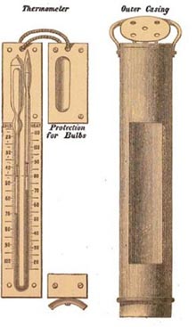
Miller-Casella Deep-sea Thermometer. The difficult-to-use instrument was particularly susceptible to sea conditions. Click image for larger view.
Today, we can use an electronic measuring device called a CTD (conductivity, temperature, depth). This torpedo-shaped instrument takes measurements at predetermined depths (e.g., every three meters over a distance of 1,000 meters). The device detects how the conductivity and temperature of the water column changes relative to depth. This information can be used to determine the salinity (the concentration of salt) of the seawater. The CTD may be deployed by itself or with a set of sampling bottles attached (a “rosette” or carousel) to collect water samples. Together, these tools are called a “hydrocast.” The sampling bottles can collect water at different depths of the cast.
Web-based Resources for Education
In partnership with educators, scientists, and historians, the College of Exploration has assembled a Challenger Team to link the pioneering HMS Challenger (1872-1876) expedition with the voyages sponsored by NOAA’s Office of Ocean Exploration. The college hopes to rekindle the spirit of the HMS Challenger. It will review the ship's historic journey, compare current ocean research tools, technologies and techniques with those used on modern voyages, and build awareness of ocean exploration.
The Challenger Team will create curricular materials for educators and students, develop a virtual exhibit based on HMS Challenger artifacts, and create a video animation of the HMS Challenger. It will make available selected digitized portions of the original Challenger reports on the Web, conduct an online educator workshop on the history of ocean exploration, and develop geographic information system (GIS) learning materials.
Future educational web resources and lesson plans related to the Challenger and to current NOAA expeditions will present more detailed explanations of the specific tools and processes used to collect oceanographic data. They also will include in-depth comparisons of the HMS Challenger to a modern research vessel and a social science component that compares life at sea in the 1800s to today.
Notes: Challenger Ship and crew pictures reproduced from original documents in the library holdings of Dartmouth College, Hanover, New Hampshire, USA. Copyright © 2003 by Dr. David C. Bossard. Other photos courtesy of NOAA Photo Library.