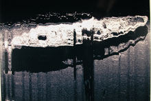
Sidescan sonar image from the Steamship Portland.
Education Lesson Plans
The National Oceanic and Atmospheric Administration's (NOAA) ocean expeditions provide a great opportunity for teachers, students, and the public to share the excitement of daily discoveries at sea and learn about the science behind its undersea explorations. The Steamship Portland Expedition presents a unique opportunity to engage explorers of all ages as we journey to a world that few have seen. Scientists using the University of Connecticut Ship Research Vessel Connecticut, sidescan sonar, and a remotely operated vehicle, will explore Stellwagen Bank National Marine Sanctuary at depths of 320-470 ft to investigate and document shipwreck sites, including the steamship Portland and the coal carriers Louise Crary and Frank Palmer. Scientists will also investigate and document unidentified targets from a multibeam sonar map.
Educators and scientists working with NOAA during September 2003 developed a series of lesson plans for students in Grades 5–12 that are specifically tied to the Steamship Portland Expedition. Lessons focus on marine archeology, the use of sidescan sonar to locate objects underwater, ocean waves and the influence of extreme storms on wave formation, extreme storms, marine navigation and position finding, and energy conversions and simple machines.
The lesson plans are grouped into the following categories:
Grades 5-6
Grades 7-8
Grades 9-12 (chemical, biological, earth, and physical science)
Each grade-level grouping includes activities that focus on the exploration and research being conducted as part of the Steamship Portland Expedition. In addition to being tied to the National Science Education Standards, the hands-on, inquiry-based activities include focus questions, background information for teachers, links to interesting Internet sites, and extensions. Web logs that document the latest discoveries and complement the lesson plans, complete with compelling images and video, will be sent back from sea every day. Teachers are encouraged to use the daily logs from the Steamship Portland Expedition, which are posted on this site, to supplement the lesson plans.
All of the lesson plans are available in pdf format, and may be viewed and printed with the free Adobe Acrobat Reader ![]() . To download a lesson plan, click on its title from the list below.
. To download a lesson plan, click on its title from the list below.
Grades 5-6
Wreck Detectives (5 pages, 384k)
Focus: Marine archaeology (physical science)
In this activity, students use a grid system to document the location of artifacts recovered from a model shipwreck site, use data about the location and types of artifacts recovered from a model shipwreck site to draw inferences about the sunken ship and the people who were aboard, and identify and explain types of evidence and expertise that can help verify the nature and historical context of artifacts recovered from shipwrecks.
Where’s the Energy? (5 pages, 384k)
Focus: Energy conversions (physical science)
In this activity, students learn the basic operation of a steam engine and identify and describe the energy conversions involved in the operation of a steam engine.
Grades 7-8
All Steamed Up (6 pages, 404k)
Focus: Energy conversions and simple machines (physical science)
In this activity, students will explain the basic operation of a steam engine, identify and describe the energy conversions involved in the operation of a steam engine, and identify at least three simple machines in a steam engine and explain their functions.
Ping! (5 pages, 384k)
Focus: Sidescan sonar (earth science/physical science)
In this activity, students will describe sidescan sonar, compare and contrast sidescan sonar with other methods used to search for underwater objects, and make inferences about the topography of an unknown and invisible landscape based on systematic discontinuous measurements of surface relief.
Grades 9-12
Fetch Me a Wave (5 pages, 388k)
Focus: Ocean waves and the influence of extreme storms on wave formation (earth science)
In this activity, students define waves and explain how they are formed, explain the factors that influence the size of ocean waves, and draw plausible inferences about the effect of extreme storm conditions on wave formation.
X-Storms (5 pages, 384k)
Focus: Extreme storms (earth science)
In this activity, students identify and explain three factors that contributed to extreme storm conditions during the Halloween Nor’easter of 1991, discover how to obtain real-time and historical meteorological data, and compare and contrast extra-tropical cyclones, tropical cyclones, and hybrid storms.
Do You Have a Sinking Feeling? (9 pages, 764k)
Focus: Marine archaeology (earth science/mathematics)
In this activity, students plot the position of a vessel given two bearings on appropriate landmarks, draw inferences about a shipwreck given information on the location and characteristics of artifacts from the wreck, and explain how the debris field associated with a shipwreck gives clues about the circumstances of the sinking ship.
Where Am I? (4 pages, 344k)
Focus: Marine navigation and position finding (earth science)
In this activity, students identify and explain at least seven different techniques used for marine navigation and position finding, explain the purpose of a marine sextant, and use an astrolabe to solve practical trigonometric problems.
For More Information
Contact Paula Keener-Chavis,
Director, Education Programs
NOAA Office of Ocean Exploration
Other lesson plans developed for this Web site are available in the Education Section.


