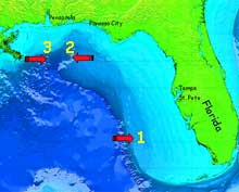
Bathymetric map of the Gulf of Mexico, with proposed dive sites for Operation Deep-Scope 2005 indicated by red arrows and yellow numbers. Site #1 is on the southwest Florida Shelf in the Gulf of Mexico, where deep-water Lophelia coral lithoherms are found. #2 is DeSoto Canyon, a deep erosional valley where upwelling of deep nutrient rich water means greater animal abundances. #3 is Viosca Knoll, the shallowest site, where spectacular stands of Lophelia provide abundant habitat for other species. Click image for larger view.
Geology: Dive Sites
Tamara Frank, Ph.D.
Biological Oceanographer
Harbor Branch Oceanographic Institution
Our first stop will be on the southwest Florida Shelf in the Gulf of Mexico, where deep-water Lophelia coral lithoherms are found. Although much of the Florida shelf is flat muddy bottom, in this region there are numerous 50 to 150 m tall lithoherms, which are mounds of limestone rock that are capped with Lophelia coral, both living and rubble. These are found at depths of 600 to 800 m. This area was first described via a dredge and seismic survey in 1987 (Newton et al, 1987) and was explored via ROV for the first time on the Ocean Exploration Deep-sea Medicines expedition in 2003. Further studies with the Johnson-Sea-Link submersible in 2004 indicate that this area provides habitat for an abundance of deep-sea species, and would be a prime location for deployment of our instrumentation.
Next, we will steam approximately 120 miles north to DeSoto Canyon, which is an erosional valley that cuts through the broad continental shelf in the northern part of the Gulf. This is an area where upwelling of deep nutrient rich water occurs, resulting in relatively high primary productivity. This means that more food is available through the food web, the end result of which is a greater abundance of animals in this region. The bottom depths here range from 800 – 1000 m. We had planned to explore this area in 2004, but were blown out by Hurricane Bonnie.
Our final dive site will be an area called Viosca Knoll. This is an area with a great diversity of habitats, ranging from muddy soft bottoms to large areas of limestone. This limestone, which formed in shallow marine areas during the geologic history of the Gulf, often rises above the sandy bottom to form knolls (small natural hills) up to 15 m high, providing hard substrates upon which animal communities can develop. At Viosca Knoll, there are spectacular stands of the deep-sea coral Lophelia, which attract a variety of fish, crustaceans such as shrimp, and echinoderms such as sea stars. This region, with a maximum depth of approximately 400 m, isn’t as deep as the lithoherms, and it will be interesting to see what differences we find between the animals that are found at these two sites.


