


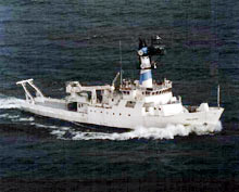
The R/V Endeavor research vessel is seen here underway during an exploration. The control vans and satellite telecomunication system which beams the signals to shore will be placed onboard the ship. Click image for larger view and image credit.
Mission Plan
SEA OF CRETE
Katherine Croff
Mary Hollinshead
University of Rhode Island
The Sea of Crete is a crossroads of maritime activity in the eastern Mediterranean region. This is the first season of a multi-year geological and archaeological study in the Sea of Crete. Our interdisciplinary research team of archaeologists and oceanographers will correlate geographic and cultural information as we consider interactions between humans and the sea. We aim to describe navigational routes and their hazards; to clarify questions about the nature and organization of communications among inhabitants of the Aegean and Mediterranean Seas, including trade and colonization; and, to correlate the archaeological record with the geological stratigraphy of the Sea of Crete. Recording seabed remains of ships in transit in the Sea of Crete will furnish essential information at a time when new questions regarding well known cultural material have led to more conscious framing of research, with the goal of explaining human activities in a maritime environment.
There will be two survey phases in the international waters of the Sea of Crete as we work aboard the R/V ENDEAVOR in 2006. We will use side scan sonar and sub-bottom profiling to locate archaeological targets; the first survey phase will be followed by closer investigation of targets using remotely operated vehicles (ROVs) to photograph and collect high-definition video imagery of each target. Still and visual imagery will be analysed by scientists both at sea and on shore to determine if it is geological or archaeological. If a target is man-made, archaeologists will determine its approximate age and place or origin. This record of remains of human activity will provide valuable information about travel and commerce throughout the long history of this maritime crossroads.
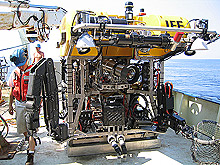
The ROV Hercules, a remotely operated vehicle which will be used during this expedition. Click image for larger view and image credit.
THERA
Haraldur Sigurdsson
Steve Carey
University of Rhode Island
Matina Alexandri
Hellenic Centre for Marine Research
In the late Bronze Age, about 1500 to 1600 BC, a huge explosive eruption occurred on the Greek island of Thera (Santorini) in the eastern Mediterranean Sea. The eruption buried the ancient town of Akrotiri and led to collapse of the island’s central part to form a submarine caldera. The majority of erupted material was in the form of pyroclastic flows, hot mixtures of gas and volcanic sediment, which advanced quickly into the ocean around the island. Most of the volcanic deposits from this eruption are therefore now on the seafloor around Thera and have yet to be studied in detail.
From April to June 2006, a team of oceanographers from the United States and Greece will conduct studies of the seafloor around Thera and inside its flooded caldera. This is a collaborative effort between the Graduate School of Oceanography of the University of Rhode Island and the Institute of Oceanography of the Hellenic Centre for Marine Research (HCMR) in Athens. The goals of this expedition are to determine the distribution and thickness of the submarine pyroclastic deposits from the eruption and to contribute to an understanding of the evolution of this important volcano. Two research cruises will be launched to survey, study and sample the seafloor, involving the use of two research vessels, side scan towfish ECHO, remotely operated vehicle HERCULES, and a variety of other oceanographic research tools.
BLACK SEA
Michael Brennan
University of Rhode Island
The expedition to the Black Sea is building upon previous years’ surveys in which well-preserved ancient shipwrecks were located and documented. One of these wrecks was found near Turkey within the anoxic layer of the sea, which is depleted in oxygen due to layering, or stratification, of the water column. This stratification occurs because the shallow outflow channel at the Bosporus Strait, the connection between the Black and Aegean Seas, does not allow for the deeper, denser water to exit. Low circulation creates the anoxic condition deeper than 150 meters, creating a hostile environment for marine organisms. Organisms that eat wood and other organic material do not have enough oxygen to survive in the anoxic water; the deep water is therefore a unique environment in which organic archaeological material can be very well-preserved.
This year’s work on the ENDEAVOR will focus on two areas south of the Crimea peninsula in the northern Black Sea. The Greek colony of Chersonesos was founded here during the Classical period (c. 5th century BC) and was inhabited up through the Middle Ages. The aim of the 2006 survey is to use side scan sonar and ROVs to locate, identify, and document archaeological sites that can tell us about the patterns of trade connected to Chersonesos, both within the Black Sea and out to the Aegean and Mediterranean. Patterns of ship traffic and cargos from around the Black Sea will help understand the nature and scope of ancient trade in the Pontus region.