


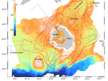
Figure 1: General map of area, showing location of Santorini (Thera) caldera and the Kolumbo submarine volcano and the distribution of the Minoan submarine pyroclastic flow deposit. The black dashed lines are seismic surveys. The red lines are contour lines of thickness of the Minoan submarine pyroclastic deposit, in meters. The dashed red line is the outer limit of the submarine deposit from this eruption. Click image for larger view and image credit
Thera 2006 Expedition Summary
Haraldur Sigurdsson
Steven Carey
Graduate School of Oceanography
University of Rhode Island
Introduction
Sometimes when you go exploring for one thing, you find something totally different and unexpected. That is the true nature of discovery and it was shown very well during the oceanographic expeditions that we conducted in the Santorini and Kolumbo submarine volcanic areas in Greece in the summer of 2006. Santorini is a world-famous volcano because of its huge eruption in the Bronze Age, about 1630 BC, but right next to it is the unknown submarine crater of Kolumbo, which erupted in 1650 AD. In collaboration with the Hellenic Centre for Marine Research in Greece (HCMR), oceanographers from the University of Rhode Island carried out two research cruises to this area from April to July 2006, on the ships R/V Aegaeo and R/V Endeavor, using a variety of research tools, including the IFE ROV’s Hercules and Argus.
The primary goal of the mission was to determine the extent and volume of the submarine pyroclastic deposits from the Minoan eruption that are distributed on the seafloor around Santorini. Not only was this goal was accomplished, but a lot of other fascinating information came to light, as described below. For more detailed information and daily logs of the expedition, see the Thera web site: http://www.uri.edu/endeavor/thera/index.html
Kolumbo Submarine Volcano
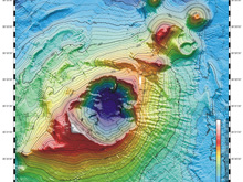
Figure 2: Map of the Kolumbo submarine crater and other submarine cones on the north-east trending Kolumbo volcano-tectonic rift. Click image for larger view and image credit
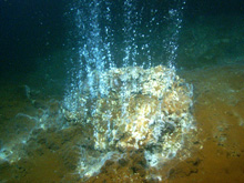
Figure 3: A high-temperature hydrothermal vent in the Kolumbo submarine crater, discharging gases. Click image for larger view and image credit
Extending from the northeast part of Santorini there is a line of about twenty submarine volcanic cones. By far the largest one is the Kolumbo submarine crater (fig. 1), with a crater that is about 1.5 km in diameter. Kolumbo was discovered in 1650 AD, when a major explosive eruption broke the ocean surface, sending destructive pyroclastic surges across the sea to the coast of Santorini. Up to 70 people died on Santorini as a result. The eruption built up a small white pumice island on the crater rim, but it was quickly destroyed by the ocean waves. This is virtually all we knew about the Kolumbo submarine crater until in April 2006, when our expedition began. During the two cruises Kolumbo was probed, using seismic surveying, SeaBeam mapping and ROV exploration (MaxRover and Hercules). We found that the floor of the Kolumbo crater is about 505 m below sea level, but the shallowest point on the south-west crater rim is only ten meters below the surface (figure 2). We sent the ROV Hercules down to the bottom to explore it further. We had an indication from earlier dives conducted by HCMR, that there was an unusual biological community inside the crater, but we never expected this! When Hercules was about half-way down to the bottom, at 250 to 300 m depth, the normally clear Mediterranean water turned very murky, with marine snow or very abundant suspended bacterial filaments and particles reducing the visibility.
When Hercules reached the bottom, it turned out that the crater floor was entirely covered by a thick blanket of a bright reddish-orange bacterial mat, which is a good indicator of hydrothermal venting near-by. Further exploration led to the discovery of a large hydrothermal vent field in the northern part of the crater floor. It consists of hundreds of hydrothermal vents that are discharging hot fluids, and some are vigorously discharging gases and fluids at temperatures up to 224°C (figure 3). The deposition of minerals in many of the hydrothermal vents has led to the construction of chimneys up to 4 m in height. Samples of the vent chimneys were brought up to the surface, and preliminary analyses show that they are composed of polymetallic sulfide/sulfate. Thus there is a mineral deposit that is actively growing in the Kolumbo crater today, and it has probably grown entirely during the 356 years that have passed since the 1650 AD eruption. The dominant minerals in this deposit are pyrite, sphalerite, galena and barite (figure 4). Abundant metals in this deposit include iron, zinc, lead, and significant quantities of copper and silver occur.
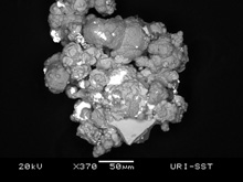
Figure 4: SEM microphotograph of a particle from the Kolumbo polymetallic massive sulfide/sulfate deposit, with crystals of galena, pyrite and sphalerite. Click image for larger view and image credit
The polymetallic massive sulfide/sulfate mineral deposit now forming in the Kolumbo submarine crater is most likely akin to Koruko-type mineral deposits that are mined on land in many parts of the world, especially in Japan. Many of the world’s riches precious and base metal deposits are of the Koruko-type, and are found in environments of subduction-related volcanism like at Kolumbo. Thus a relationship between this type of ore formation and magmatism is graphically displayed by ore mineralization around high-temperature vents in submarine volcanoes such as Kolumbo. Here hot anaerobic fluids rise to the surface on the crater floor and mix with cold and oxic seawater, to form chimney-like structures of metal sulfides and sulfates. The Kolumbo deposit is a very rare example of the formation of a Koruko-type deposit forming today, and its study is therefore very important for understanding the formation of the economic ore deposits that are being mined on land.
The Minoan Eruption
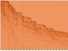
Figure 5. Seismic profile line A034 to the west of Santorini showing a hummocky upper sequence interpreted to be pyroclastic deposits from the Minoan eruption. Click image for larger view and image credit
When the Santorini caldera exploded in the Late Bronze Age (ca. 1630 BC), it produced the second largest explosive eruption in historical time (the other being the eruption of Tambora in Indonesia in 1815). This Santorini eruption occurred at a time when the Minoan civilization was dominant in the Aegean Sea, and hence it is generally called the Minoan eruption. Researchers from the University of Rhode Island began studying the products from the Minoan eruption in 1975 by taking sediment core samples of the sea floor between Santorini and Crete, and we concluded at that time that the eruption produced at least 39 km³ of magma.
During the R/V Aegaeo cruise in 2006 we made a great advance on the study of the Minoan eruption by applying seismic air-gun techniques in order to determine the thickness, distribution and volume of the submarine volcanic deposit of pumice and ash on the sea floor around Santorini (figure 1). We found that a thick pyroclastic deposit, representing pyroclastic flows from the Minoan eruption (figure 5), can be traced up to 30 km from the volcano and that it ranges in thickness from ten to eighty meters. Its distribution is remarkably similar to the submarine pyroclastic flows from the 1883 eruption of Krakatau in Indonesia – only the Minoan is much bigger. Our results show that the volume of the Minoan deposit on the sea floor is about 41 km³, but to this must be added the distal fallout ash (17 km³), and ignimbrites on the Santorini islands (1.5 km³). Thus the total volume of this important eruption is likely about 60 km³. This much increased volume estimate has important implications for the size of the tsunami waves that may have been generated by the Minoan eruption.Debris Avalanche?
In the basin on the south-east side of Santorini the pyroclastic deposit includes a large number of blocks or hummocks that range from 10 to 200 m in diameter and protrude about 20 to 40 m above the general flow surface. The hummocky topography of the seafloor in this region is very well displayed in the slope map derived from the multibeam data (figure 6). This hummocky deposit extends more than 20 km from the volcano. We consider the possibility that the source of these blocks may be found in the Profitis Ilias – Mesa Vuono crystalline metamorphic massif in south-eastern Santorini, and that their distribution may be related to a debris avalanche, perhaps contemporaneous with the Minoan eruption. Some geologic features on Santorini are important in this regard. The rock of Monolithos is an isolated 50 m long outcrop of marble and limestone that sticks out ca. 20 m above the surrounding ignimbrite plain at the east coast of Santorini, close to the island’s airport runway. In the town of Kamari at the foot of the Profitis Ilias – Mesa Vuono massif in south-east Santorini there occur two other isolated crystalline limestone or marble outcrops in the ignimbrite plain, ca. 15 m high and 30 to 50 m long. These isolated outcrops may be debris avalanche blocks (figure 7).
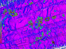
Figure 6: Part of the hummocky deposit found on the seafloor east of Santorini. This deposit may be formed as a result of a debris avalanche, originating in the Profitis Ilias - Masa Vuono mountain complex on southeastern Santorini. Hummocks are indicated by green and brown color (steep slope); whereas the surrounding slat-lying pyroclastic deposit is indicated by purple and blue color. Click image for larger view and image credit.
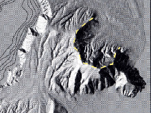
Figure 7: The prominent horse-shoe shaped scar (dashed yellow line) in the Profitis Ilias - Mesa Vuono mountain complex in the south-eastern part of Santorini (Thera) may be the source of the debris avalanche deposit found on the sea floor to the east of the volcano. Click image for larger view and image credit.
The Profitis Ilias – Mesa Vuono metamorphic complex is up to 575 m in height and consists of crystalline limestones of Triassic age and low-grade metapelites of Paleocene-Eocene age. The eastern part of the massif is a very steep slope that forms an east-facing amphitheater-like feature, defined by the arcuate limestone ridge Exo Gonia-Pirgos-Profitis Ilias. In addition, a much smaller possible east-facing slide scar occurs between Mesa Vuono and Profitis Ilias. Finally, the seabeam data show a “bite” out of the eastern submarine platform of Santorini from 36° 21.73’ N and 36° 23.53’ N, in line with these features on land and at the landward end of the block-bearing submarine deposit. All of these features suggest that a partial collapse of the flank of Profitis Ilias generated a major debris avalanche into the ocean to the east, which may have occurred due to intense local earthquake activity during the Minoan eruption.
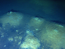
Figure 8. Low temperature hydrothermal mounds in the northern part of the Santorini caldera. Diameter of the mound is of the order of a meters. Click image for larger view and image credit.
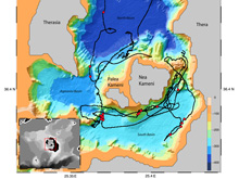
Figure 9: The distribution of hydrothermal vents within the Santorini caldera is shown with red dots. The black lines show the track of ROV Hercules on the caldera floor. Click image for larger view and image credit.
Santorini Caldera
The floor of the Santorini caldera was also explored with ROV Hercules. A large number of hydrothermal vents were discovered (figure 8), but in contrast to the high-temperature venting found in Kolumbo submarine volcano, only relatively low-temperature venting was observed within the Santorini caldera. The present configuration of the caldera consists of three distinct basins that form separate depositional environments, divided by the Kameni volcanic islands. The largest is the North Basin (389 m), to the west is the Aspronisi Basin (325 m), and the shallowest is the South Basin (297 m). The new seismic lines show that sediments in the Santorini caldera consist primarily of terrigenous material and volcaniclastic deposits from the activity of Kameni islands. Hydrothermal vents occur in both the North and South Basin of the caldera. They form a vent field in the NE part of the North Basin that is 200 by 300 m in extent (figure 9). The vents form hundreds of 1 to 4 meter diameter mounds of yellowish bacterial mat that are up to 1 meter high. Temperatures in the mound are around 15 to 17° C or about 5° C above ambient temperature. The North Basin hydrothermal vent field is located in line with the normal fault system of the Kolumbo rift, and also near the margin of a shallow intrusion that occurs within the sediments of the North Basin. Similar vent mounds occur in the South Basin, where most of the low temperature vents are seeps along a ridge separating the West and South Basins and on the submarine flanks of the Kameni volcanic islands.
Sign up for the Ocean Explorer E-mail Update List.