


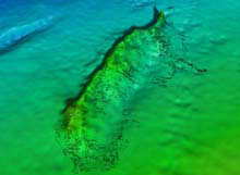
Figure 1. In this illustration, a drawing of the Viosca Knoll Wreck site is “draped” over the multibeam bathymetry (water depth) image. Click image for larger view and image credit.
Deep Wrecks 2009
Daniel J. Warren
Principal Investigator
Robert A. Church
Co-principal Investigator
Robert F. Westrick
Marine Archaeologist
Marine Archaeology Group
C & C Technologies, Inc.
![]() This video shows a three-dimensional perspective of the Ewing Bank Wreck.
This video shows a three-dimensional perspective of the Ewing Bank Wreck.
On September 5, a team of archaeologists and other scientists will join the NOAA research vessel (R/V) Ronald H. Brown at sea in the Gulf of Mexico for the second leg of the Lophelia II 2009: Reef, Rigs, and Wrecks cruise. Their mission will be to document thoroughly four or five historic deep-water shipwrecks that were discovered during oil and gas surveys. The objectives during the second (shipwreck) leg of the cruise are designed to meet both archaeological and biological goals. The research team will document, in detail, each wreck’s current condition and gather clues to their identity, origin, cargo, and purpose. They will also conduct microbiological experiments and collect data to determine each wreck’s state of preservation and rate of deterioration. These wrecks serve as a hard substrate in areas of the seafloor that are mostly devoid of hard surfaces. The team will document the variety of corals, fishes, and other invertebrates present at the sites. All five wrecks are historically significant and potentially eligible for inclusion in the National Register of Historic Places, and the team hopes to further unravel the mystery of these intriguing unidentified shipwrecks.
Four of the wrecks may date from the nineteenth century, which was a pivotal period of history, with the War of 1812, the American Civil War, the sunset of piracy and slave smuggling, and transitions in industrial technologies. The shipbuilding industry, in particular, was significantly altered during this era. As per John William Morris: “A ship represents one of the greatest achievements of any society. When shipbuilders constructed a ship; they were literarily sending to sea the finest technology they could produce. What one sees in a shipwreck of any particular period, is what the space shuttle would represent to our society today.”
Studying these ships teaches us how they were built and helps us learn not only about the people who built and worked on them, but about the society they represent. The research team aboard the R/V Ron Brown will use one of today's most advanced underwater vehicles, the remotely operated vehicle (ROV) Jason II, to explore the maritime technology and history of this unique cross section of wooden sailing vessels. The team will attempt to decipher the historic and cultural significance of each wreck as well as study their present role as deepwater artificial reef ecosystems.
The Viosca Knoll Wreck, named for the Viosca Knoll area where it is located, will be the first site we visit on this leg. Discovered in 2003, the wreck lies 612 meters (2,007 feet) below the surface. This wreck is a copper-clad sailing vessel measuring 45 m (148 ft) long, and 10 m (33 ft) at the beam. Small colonies of Lophelia coral are growing on several sections of the hull and outlying debris. C & C Technologies, Inc. (C & C) conducted a remote sensing survey in 2004 using the C-Surveyor I autonomous underwater vehicle (AUV) (Figure 1), followed by an ROV investigation of the site as part of a U.S. Mineral Management Service (MMS) shipwreck study (MMS 2008-018), in 2006. Remote-sensing surveys typically include the use of geophysical equipment such as side can sonar to detect object on the seafloor; bathymetric systems to acutely measure water depth; and subbottom profilers to view beneath the seafloor. These geophysical surveys are key in both finding and investigating shipwrecks.
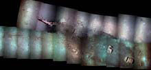
Figure 2. This photo mosaic of the 7,000-ft Wreck. Images collected in June 2009 with Woods Hole Oceanographic Institution's Sentry autonomous underwater vehicle. Click image for larger view and image credit.
The second planned site visit is to a location known as the “7,000-ft. Wreck,” although it is actually in 7,400 ft (2,256 m) of water in the Mississippi Canyon area. This site was found in 1986 and resurveyed in 2006 with the C-Surveyor I AUV. The Woods Hole Oceanographic Institute (WHOI) Sentry AUV brought back the first still photographs of the wreckage this summer. The photomosaic made from these images (Figure 2) shows that the wreck is unquestionably an historic sailing vessel, but its identity, purpose, and origins remain a mystery.
From the 7,000-ft Wreck, the team will transit west to investigate the Ewing Bank Wreck. First discovered with the C-Surveyor I AUV in 2006, it was investigated during the first leg of the 2008 Reef, Rigs, and Wrecks cruise using a Seaeye Falcon ROV. The vessel is a copper-clad sailing ship measuring 40 m (131 ft) in length, and 10 m (33 ft) at beam. Colonies of Lophelia coral are growing on the wreck, particularly on the stem post at the bow. This summer, C & C collected digital still images and high-resolution multibeam bathymetry data of the wreck using the C-Surveyor III AUV. The photomosaic created from these images provides a complete picture of the wreck. Having a variety of data (i.e., video, photographs, side scan sonar, multibeam bathymetry, etc.) helps researchers to better understand the site. The photomosaic of the Ewing Banks Wreck was “draped” over the multibeam imagery, giving the research team a three-dimensional geo-referenced model to help plan work at the wreck site.

Figure 3. The ship’s starboard lantern at the Green Lantern Wreck site was discovered lying among other artifact scatter. Click image for larger view and credits.

Figure 4. The Lophelia colonies at the Gulfpenn Wreck site exhibit 4.6 m (15 ft) of vertical relief along the superstructure. It is literally a wall of coral. Click image for larger view and credits.
The final wooden shipwreck the team will investigate is the Green Lantern Wreck, an unidentified shipwreck dating to the mid-nineteenth century. The vessel was found in 1996 and resurveyed in 2004 with the C-Surveyor I AUV. The wreck is a copper-clad sailing vessel measuring approximately 20 m (65 ft) in length. The site was named for one of the ship’s lanterns, which was found lying near the stern. The lantern appears to be made of copper or brass and has a greenish hue (Figure 3). The word “Estribor,” Spanish for “starboard,” is embossed on its face.
If time allows, we plan to dive on the World War II tanker, Gulfpenn. Built in 1921, Gulfpenn was torpedoed by German U-boat, U-506, on May 13, 1942, while transiting across the Gulf of Mexico, with 90,000 barrels of fuel oil. The vessel was found in 1994 and was investigated in 2004 as part of the MMS/NOAA OER Deep Wrecks Study (MMS 2007-15). The science team revisited the site during the first leg of the 2008 Reef, Rigs, and Wrecks cruise. This site has extensive Lophelia coverage as well as deep reef fishes and various other invertebrates (Figure 4).
Sign up for the Ocean Explorer E-mail Update List.