


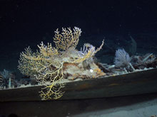
Paramuricea is located along the edge of the hull. Click image for larger view and image credit.
Mission Summary
August 19 - September 12, 2009
Erik Cordes
Lophelia II Chief Scientist
Assistant Professor
Temple University
After nearly a month at sea, 20 dives with the ROV Jason II at 17 sites (including 5 shipwrecks), and an incredible 356 hours of bottom time, we had a great number of successes on this expedition. We mapped out about 20 km2 of seafloor for the first time, and using Jason we obtained high resolution maps of the seafloor in which we could identify individual coral colonies. We found some fanatastic new Lophelia sites, including the “Roberts’ Reef” site in Viosca Knoll 906. This site contained huge, uninterrupted fields of Lophelia and also contained a high level of diversity of black corals that contributed to the heterogeneity of the habitat, not to mention a splash of color and the overall aesthetic appeal of the site. This site is also the first reported cold-water carbonate mound in the Gulf, a feature that is quite common at the Lophelia sites of the Atlantic. The features of this site will change the way we look for Lophelia in the future. We also confirmed a previous sighting of Lophelia about 200 km further west in the Gulf than it had ever been reported, in Green Canyon 535. This site will provide a wealth of information on the population genetics and larval dispersal of Lophelia as we begin to work up our samples.
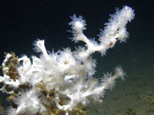
A close-up of the scleractinian coral Lophelia pertusa from the Mississippi Canyon 751 site at approximately 450 m depth. This image was taken with the SeaEye Falcon DR ROV during the first cruise of this program in September 2008. Click image for larger view and image credit.
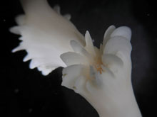
Close-up of Lophelia pertusa calyx with polyp retracted. Click image for larger view and image credit.
This process of working up our samples will take a long time. Hopefully, we have gathered enough here to last us (at least) a year until we can come out again. One of the top priorities for a number of labs will be to determine what we actually collected! We made a lot of collections of coral species, and some collections of the communities associated with the corals and the sediments surrounding them. Identifying the species in these collections is a long process involving classical techniques based on the appearance of the individual, and also the latest genetics tools. We hope that we will ultimately determine that we have a bunch of new species of corals and their associates, but it is a little too early to tell for sure. These studies will also help us identify the species in the huge number of pictures we took on the cruise. These images will help us describe the communities at the sites at different spatial scales. The images from the shipwrecks will also help us estimate the growth rates of the corals, once the images of the shipwrecks and the great artifacts that were recovered tell us the age of the wreck itself. We collected a lot of live corals, and these were transported back to the tanks waiting at Temple University and Penn State. So far these corals are doing well and will be the subject of a series of experiments in which we hope to determine what ranges of environmental factors they can tolerate. We also obtained a series of water samples that provided the first estimates of the alkalinity and aragonite saturation state for the deep Gulf of Mexico, a story that is just beginning to unfold and will be a focus of future research. Finally, we placed a series of long-term deployments out on the seafloor. These will be gathering information on the currents, temperatures, food supply, and larval supply at some of our key sites, and our camera system will be taking pictures of a nice Lophelia reef to see who has been visiting it while we were gone. When we return next year, these will immediately provide another huge batch of data for us to spend another year (or more) analyzing. Hopefully our cruise next year goes as well as this one did!
The project archaeologists have started the lengthy process of examining all the ROV data from the shipwreck sites visited this year. Much like crime scene investigators, they are looking for evidence to tell each wreck’s story. Reviewing the data will take several months to complete, but once it is done what they find will help us understand how these wrecks sank, what they were carrying, how they were built, and where they came from. Already, newly discovered clues are helping to solve the mysteries of these lost ships. Many clues come from the artifacts collected from the wrecks during the 2009 cruises. Although interesting in themselves, the artifacts are just more than objects to admire. Studying how and when they were made and what they were used for can tell us about the people who lived, worked, and possibly died on these ships. The artifacts are currently undergoing conservation at West Florida University, but they have already helped to date the periods when several of the ships were lost. As the research on the shipwrecks progresses and information from future cruises is added, each wreck’s story will unfold for the archaeologists to decipher and tell.
Sign up for the Ocean Explorer E-mail Update List.