By
Kelley Elliott, Expedition Manager - NOAA Office of Ocean Exploration and Research
Santiago Herrera, Biology Science Lead - Lehigh University
Matthew Jackson, Geology Science Lead - University of California Santa Barbara

Map showing the general expedition operating area. The green dots are the planned ROV dive sites for the February 16 to March 2 cruise and the red dots are ROV dive sites that are planned for other cruises. The green polygons are the priority mapping areas for the expedition. These areas were identified by NOAA partners, with input from American Samoa management agencies and from NOAA’s 2017 Central Exploration Call for Input and regional workshops. The white line shows the boundaries of the U.S. Exclusive Economic Zone of American Samoa, and the light blue boxes are the boundaries of the Rose Atoll Marine National Monument and National Marine Sanctuary of American Samoa. The Swains Island inset box is another unit of the National Marine Sanctuary of American Samoa located further north than the map area. Image courtesy of NOAA Office of OCean Exploration and Research, 2017 American Samoa. Download larger version (jpg, 315 KB).
From February to April 2017, NOAA and partners will conduct two telepresence-enabled ocean exploration cruises on NOAA Ship Okeanos Explorer to collect critical baseline information of unknown and poorly known deepwater areas in American Samoa, Samoa, and the Cook Islands, with an emphasis on the Rose Atoll Marine National Monument (RAMNM) and the National Marine Sanctuary of American Samoa (NMSAS).
This expedition is part of a three-year Campaign to Address the Pacific monument Science, Technology, and Ocean NEeds (CAPSTONE), a foundational science initiative to support science and management decisions within and around U.S. marine protected areas in the central and western Pacific. The campaign also serves as an opportunity for NOAA and the nation to highlight the uniqueness and importance of these national symbols of ocean conservation.
Despite the role that the ocean plays in supporting our well-being, 95 percent of the world’s ocean remains unexplored using advanced technologies. Increasing baseline knowledge of ocean habitats is critical to the conservation and preservation of these remarkable ecosystems. Exploratory missions, such as those conducted via Okeanos Explorer, are necessary to expand our knowledge of the unknown and to provide baseline data for resource managers.
Very little is known about deep-sea habitats, including deep-sea coral and sponge communities, in American Samoa. Data and information from our expedition will fill gaps in knowledge about the deep-sea habitats in the region and improve our overall understanding of the deep-sea biogeography of the Central Pacific. American Samoa lies at the boundary between major biogeographic provinces and thus is a key area to understand the biodiversity transitions that occur in the deep Pacific Ocean. Furthermore, the Samoan Passage north of the American Samoan islands is a major circulation gateway for deep water flowing from the southern Pacific into the Northern Pacific, thus representing a potential longitudinal barrier for larval dispersal, while also potentially serving as a ‘funnel’ for latitudinal connectivity.
Much also remains to be learned about the geology around the Samoan region. Like the Hawaiian chains, the Samoa islands and seamounts form an age-progressive volcanic hotspot: the volcanoes on the eastern portion of the Samoan hotspot are young, and the volcanoes in the west are progressively older. However, it is still not understood how a Samoan volcano evolves over time, or even how long it takes for a Samoan volcano to pass through its lifecycle. In order to better understand the evolution of a Samoan volcano, this expedition will sample various volcanoes at different stages in their development, including the young active volcano, Vailulu’u, and the older Samoan volcanic feature that defines the island of Tutuila. But there may be some surprises along the way: the sampling campaign may reveal that some of the volcanoes that populate the Samoan region do not trace their heritage to the Samoan hotspot, but may instead relate to older hotspots that contributed volcanism to the Samoan region tens of millions of years ago.
Baseline data from this expedition will help improve our understanding of the geologic history and deep-sea habitats of American Samoa, the connection between deepwater and shallow water ecosystems, the connection between communities at different seamounts, and the potential geohazards such as undersea landslides. Data will also provide critical information for the development of management plans for marine protected areas; support local scientists and managers seeking to understand and manage fisheries resources; and provide a foundation of information to stimulate follow-on exploration, research, and management activities.

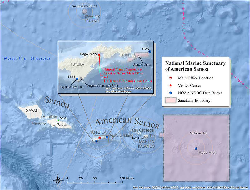
National Marine Sanctuary of American Samoa is comprised of six protected areas, covering 13,581 square miles of nearshore coral reef and offshore open ocean waters across the Samoan archipelago. NOAA co-manages the sanctuary with the Government of American Samoa and works closely with communities adjacent to the sanctuary, all within the context of Samoan cultural traditions and practices. Exploration of deepwater areas here will provide a foundation of baseline information to help the Sanctuary and Monument understand and manage its resources. Image courtesy of NOAA. Download larger version (jpg, 329 KB).

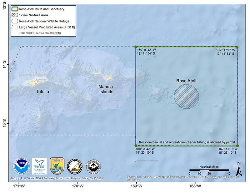
Rose Atoll is the easternmost Samoan island and the southernmost point of the United States. This small atoll remains one of the most pristine atolls in the world, and the marine environment around Rose Atoll supports a dynamic reef ecosystem that is home to a diverse assemblage of marine species, many of which are threatened or endangered. The deepwater areas around the atoll are largely unknown. Image courtesy of NOAA. Download larger version (jpg, 238 KB).
This two-part Okeanos Explorer expedition to the central Pacific will focus on deepwater exploration of American Samoa. Mapping operations and remotely operated vehicle (ROV) dives during other cruises will also address expedition priorities. The tentative schedule for the two cruises focused on American Samoa is:

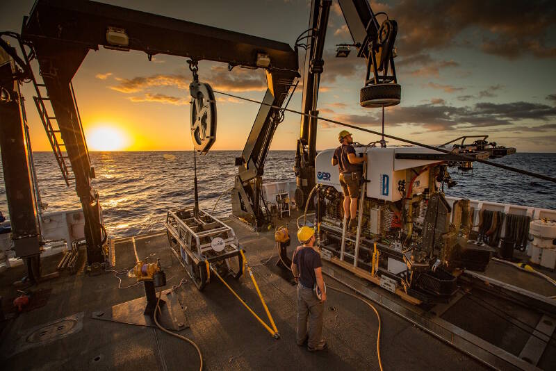
The ROVs are prepared for deployment on the aft deck of NOAA Ship Okeanos Explorer. The dual-body ROV is dedicated to the ship and includes the camera sled Seirios (left) and ROV Deep Discoverer (right). Both vehicles are outfitted with powerful lighting, high-definition imaging, and sensors to collect in situ environmental information on habitats being explored. Deep Discoverer is also equipped with a temperature probe, and two manipulator arms, coral cutters, and storage boxes for sample collections. Image courtesy of the NOAA Office of Ocean Exploration and Research. Download larger version (jpg, 875 KB).
The 2017 American Samoa expedition will address science themes and priority areas put forward by scientists and managers from NOAA, management agencies in American Samoa, and the broad ocean science community. Operations are being planned to complement previous and planned work in the area.
NOAA priorities for the 2017 expedition include a combination of science, education, outreach, and open data objectives that will support management decisions at multiple levels:
This expedition is part of the three-year Campaign to Address the Pacific monument Science, Technology, and Ocean NEeds (CAPSTONE), an effort to explore high-priority unknown areas in the Pacific marine national monuments and national marine sanctuaries. The central and western Pacific monuments and sanctuaries encompass over one million square miles of emergent land, coral reef, ocean, and maritime heritage resources, as well as harbor numerous protected species and likely an abundance of undiscovered resources. CAPSTONE provides timely, actionable information to support science-based decision making regarding some of these last relatively pristine marine ecosystems on the planet.

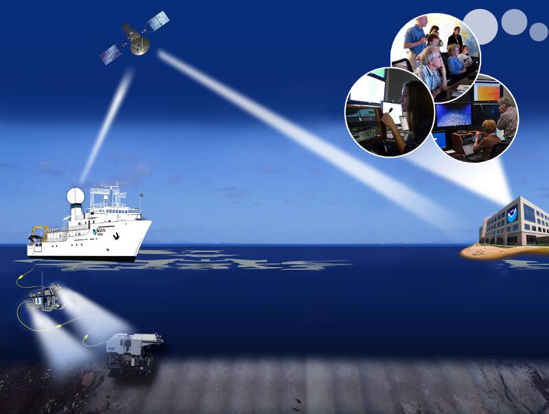
NOAA Ship Okeanos Explorer uses telepresence technology to transmit data in real time to a shore-based hub where the video is then transmitted to a number of Exploration Command Centers located around the country as well as to any Internet-enabled device. Access to the video combined with a suite of Internet-based collaboration tools allow scientists on shore to join the operation in real-time, and allows the general public to follow the expedition online. Image courtesy of the NOAA Office of Ocean Exploration and Research. Download larger version (jpg, 1.2 MB).
NOAA Ship Okeanos Explorer uses telepresence technology to transmit data in real-time to a shore-based hub where the video is then transmitted to a number of Exploration Command Centers (ECCs) located around the country as well as to any Internet-enabled device. Access to the video combined with a suite of Internet-based collaboration tools allow scientists on shore to join the operation in real time and allows the general public to follow the expedition online.
The United States’ first and only federal vessel dedicated to exploration of our largely unknown ocean, NOAA Ship Okeanos Explorer, conducts operations in a globally unique way, using telepresence to engage the majority of the science team from shore. Via telepresence, real-time video and other oceanographic data are transmitted through satellite and high-speed Internet pathways to scientists around the country.
Scientists access the live feed by standing watches in ECCs, tuning in to the high-definition video via Internet-2 or watching the live video on standard Internet from their home institutions. Shore-based scientists interact with the ship through a teleconference line and Internet collaboration tools. Using these communication tools, the scientists and students can contribute expertise and help guide the at-sea operations in real time, extending the reach of ocean exploration to more scientists and students than could possibly be accommodated onboard.
A number of ECCs will be online for the expedition, including viewing centers joining Okeanos Explorer operations for the first time. Formal ECCs include: the University of Hawaii at Manoa; NOAA's Inuoye Regional Center in Hawaii; NOAA Headquarters in Maryland; Harbor Branch Oceanographic Institution in Florida; Inner Space Center at the University of Rhode Island; Stennis Space Center in Mississippi; University of New Hampshire; and Pacific Marine Environmental Laboratory in Washington and Oregon. In American Samoa, the National Marine Sanctuary will have specialized viewing events at the Tauese P.F. Suina Ocean Center. UnderwaterWorld Guam will continue sharing the live video feeds with students and visitors, and in Independent Samoa, a viewing center may be set up at the National University of Samoa.
Scientists are also expected to participate from a number of other remote locations around the country and world. These scientists, and others on call if a discovery is made at sea, will contribute their expertise in real time to operations at sea.
This expedition provides extensive opportunities for the public to connect to the mission. The live video feeds are available to anyone online, providing the public with a front row seat to exploration activities and discoveries as they are made.
Web content developed for this expedition includes background content; mission logs; daily updates; videos and images; near real-time ship tracking features; and a live video feed. Education materials allow educators and students to engage their classrooms using products tied to the expedition, including standards-based lesson plans, background information, ocean career connections, links to previous Office of Ocean Exploration and Research-sponsored expeditions, and more.