


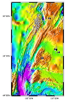
Map view of the bathymetry and earthquakes (white dots) located along the Explorer Ridge and the surrounding region. Yellow-shaded bathymetry shows seafloor less than 1000m deep; green 1000-2000m deep; blue greater than 2000m. The earthquakes shown in this map occurred between August 1991and January 2001 and were located using the U.S. Navy's SOSUS hydrophones. Click image for larger view.
Sound in the Deep Sea
Robert Dziak
Seismologist
NOAA, Pacific Marine Environmental Laboratory
Listening to underwater sound, known as hydroacoustic monitoring, of the North Pacific Ocean has revealed the region to be dynamic and constantly evolving both biologically an geologically. Monitoring ocean sounds has allowed us to listen to the movement of magma through the seafloor during three major volcanic eruptions. We also have observed large-scale faults shatter the ocean crust, and have monitored seafloor geysers as they change their eruption pattern in response to these seafloor upheavals. Moreover, we have been able to establish the geographic variation and distribution of blue whale calls in the north Pacific. The Explorer Ridge, located in the northern corner of the region off the coast of Vancouver Island, has been shown to be an acoustically lively area exhibiting earthquakes and whale calls almost continuously over the last 11 years.
Hydroacoustics is the study of sound in water. Because of the physical properties of the ocean, light waves can only travel a few feet in water before their energy is absorbed. In contrast, sound waves travel great distances underwater without losing strength, making sound a very effective method for observing geological and biological phenomena in the ocean. We use a series of underwater microphones (called hydrophones) to listen in on these natural phenomena and find out where in the ocean they occur.
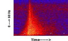
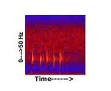
This diagram, called a spectrogram, shows the acoustic signal of an earthquake located near Astoria Canyon as recorded on a SOSUS hydrophone. The horizontal axis of the hydrophone record is time (white ticks are 1-minute intervals), the vertical axis is frequency (from 0 to 60 Hz), and the colors represent the varying strength of the earthquake's acoustic energy. Typically, an earthquake produces a triangular-shaped signal on a spectrogram with the highest acoustic energy (yellows and reds) occurring in the 5 to 30 Hz frequency range. Click image for larger view.
Listening to the North Pacific Ocean
Since 1991, the NOAA Vents Program has performed hydroacoustic monitoring of the north Pacific Ocean using a set of U.S. Navy hydrophones called the SOund SUrveillance System ![]() (SOSUS). These hydrophones rest directly on the seafloor at several locations throughout the north Pacific Ocean, and are essential for studying the frequency characteristics of the sound signals we record. Frequency is the amount of time it takes for successive peaks of a sound wave to pass by an observation point. It is depicted in units of cycles per second, commonly referred to as Hertz (Hz). Humans generally can hear sound waves with frequencies between 20 and 20,000 Hz. Below 20 Hz, sounds are referred to as infrasonic; above 20,000 Hz is referred to as ultrasonic. Using SOSUS, we have recorded the very low-frequency, infrasonic signals of earthquakes, volcanic eruptions, and blue and fin whale calls, as well as the audible sounds of passing ships, and the background rumble of passing storm systems.
(SOSUS). These hydrophones rest directly on the seafloor at several locations throughout the north Pacific Ocean, and are essential for studying the frequency characteristics of the sound signals we record. Frequency is the amount of time it takes for successive peaks of a sound wave to pass by an observation point. It is depicted in units of cycles per second, commonly referred to as Hertz (Hz). Humans generally can hear sound waves with frequencies between 20 and 20,000 Hz. Below 20 Hz, sounds are referred to as infrasonic; above 20,000 Hz is referred to as ultrasonic. Using SOSUS, we have recorded the very low-frequency, infrasonic signals of earthquakes, volcanic eruptions, and blue and fin whale calls, as well as the audible sounds of passing ships, and the background rumble of passing storm systems.
As part of the northeastern Pacific Ocean, the Explorer Ridge has been continuously monitored for natural sounds during the past 11 years. The Explorer Ridge is a geologic area called a “seafloor spreading center.” A spreading center is a place where one great tectonic plate (the Juan de Fuca) is moving away from another great plate (Pacific). Typically, these spreading centers produce vast amounts of earthquakes, seafloor volcanic eruptions, and extensive fields of seafloor hotsprings (called hydrothermal vents). Some 500 earthquakes have occurred in and around the Explorer Ridge in the past 11 years. So. it is clear that spreading centers are areas of great natural mayhem and tremendous geological turmoil. Previous maps of the Explorer Ridge indicate it has experienced several submarine volcanic eruptions in the recent geologic past, undoubtedly wreaking tremendous havoc on the fragile ecosystems in and around the seafloor hydrothermal vent systems.
The Leviathan's Call
The Explorer Ridge also lies within the migratory corridor for many species of whales, including the blue whale and fin whale. The blue whale is the largest whale in the world, reaching over 100 feet in length. Fin whales are the second largest of the great whales, growing up to 70 feet long. Blue whales were hunted to near extinction in the Gulf of Alaska and off Vancouver Island in the 1930s. Thus, very few animals have been sited in this region since then. However, recent acoustic data have indicated that blue whales still exist in this area and can be heard from September to December. Blue whale vocalizations are very loud, low-frequency, two-part “moans” that are below our threshold of hearing. Fin whale calls are also loud and infrasonic. But instead of a moan, fin whales produce a series of very short pulses. Blue and fin whale calls are typically recorded by the SOSUS hydrophones during the late summer, fall and early winter months.
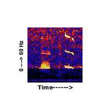
Spectrogram (top) of a Northeast Pacific blue whale call. Northeastern Pacific blue whale calls are perhaps the best known blue whale call to date. They generally consist of two parts: A and B. The A call is a series of pulses (about 1.5 pulses per second) which often exhibits side-banding. The B call is a long moan. These calls have been recorded from offshore Vancouver Island B.C., Washington, Oregon, California, off Mexico in the Gulf of California and in the Eastern Tropical Pacific. Picture (below) of a blue whale. Click images for a larger view and to listen to a blue whale (wav, 376k). Click image for larger view.
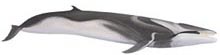
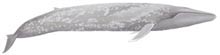
The call of the fin whale (top) is a short, pulsive call typically centered at about 20 Hz. The streamlined shape (below) of the fin whale allows it to swim at speeds greater than 20 mph. Click images for a larger view and to listen to a fin whale (wav, 232k). Click image for larger view.