


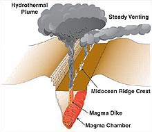
This illustration of a small segment of mid-ocean ridge crest shows the development of hydrothermal plumes, which indicate the presence of vents. Click image for larger view and more information.
Exploring for Hydrothermal Systems in the Deep Ocean
Oases on the Seafloor
Dr. Edward T. Baker
Supervisory Oceanographer
NOAA, Pacific Marine Environmental Laboratory
Scattered along the barren ocean floor lie uncounted oases of hot, chemical-rich springs. Fluids from these springs construct mineral deposits and nurture unique biological communities. They alter deep-sea circulation patterns and profoundly influence ocean chemistry and biology. They account for about 10 percent of the heat loss from the entire solid earth. Even 25 years after their discovery, we know far less about their distribution on the seafloor than about the distribution of craters on the far side of the moon.
Seafloor hydrothermal sites are a submarine version of Yellowstone National Park. Cold seawater in deep cracks is heated by cooling magma, becomes buoyant, and rises to the seafloor. Instead of forming a warm pond, as at Yellowstone, the hot fluid rises like a hot-air balloon into the cold ocean, cooling as it mixes with the cold seawater. Mixing continuously dilutes the hot discharge and increases its volume as it rises, until the hydrothermal plume achieves neutral buoyancy and is dispersed by the local currents. This hydrothermal circulation pattern occurs wherever seafloor cracks can channel seawater to layers of hot rock.
The Submarine Ring of Fire
Conditions favorable for hydrothermal venting predominantly occur in two deep-ocean environments where magma rises to form new crust: mid-ocean ridges and island arc volcanoes. Mid-ocean ridges are linear features winding some 60,000 km across the ocean floor wherever two of the Earth's tectonic plates diverge. Island arc volcanoes are point sources of magma delivered to the ocean floor by mantle melting occuring along the 22,000 km of oceanic subduction zone where two plates converge. At ridges, the ocean crust is created, while at island arcs, it returns to the Earth's mantle. These two environments form the “Submarine Ring of Fire,” surrounding the Pacific Ocean.
The Explorer's Toolkit
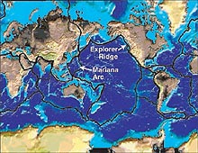
On this map of the Earth's surface, the plate boundaries are marked by a heavy black line. The boundary on the east side of the Pacific is a divergent boundary where the Pacific Ocean is being formed. Meanwhile, the boundary on the west side of the Pacific is primarily convergent, where the Pacific Ocean crust is subducted beneath more westerly plates and returns to melt within the mantle. Click image for larger view and more information.
Exploring for hydrothermal systems requires a basic set of tools and appropriate search strategies. The explorer's toolkit includes detailed maps of the seafloor, instruments to detect plumes, and vehicles to search the seafloor. Search strategies vary according to the environment under investigation.
No search can begin without detailed bathymetric maps that precisely define the shape of the seafloor. Seafloor bathymetry provides a roadmap that greatly narrows the search areas and identifies seafloor areas conducive to the development of vent fields. Mid-ocean ridges are continuous linear features, and hydrothermal fields may occur virtually anywhere along their path. Venting on island arc volcanoes occurs mostly at their summits, which are typically separated by tens of kilometers along the arc.
While seafloor hydrothermal sites on ridges and arcs are likely numerous, the active discharge orifices themselves are small, scattered, and difficult to find. The chance of success can be greatly increased by searching first for the tell-tale plumes the vents emit, and not the vents themselves. As a trail of wind-blown smoke draws the eye to a smokestack, oceanographers use maps of hydrothermal plume tracers that lead back towards a field of vents. The tracers can be physical measurements such as changes in temperature, salinity, and optical characteristics of the water. Chemical characteristics of the plume are also used, including various trace metals and gases common in a hydrothermal discharge.
Finding a Small Plume in a Big Ocean
These tracers are mapped both by real-time measurements in the plume itself and by collecting water samples for later analysis. The basic tool, used by oceanographers around the world, consists of a Conductivity-Temperature-Depth (CTD) package combined with sampling bottles that can be closed on demand. Added to this are specialized sensors that can detect specific hydrothermal tracers. The package can be lowered vertically to the seafloor while the research ship holds position, gathering data and collecting samples throughout the water column. A more effective strategy for plume hunting is a “tow-yo,” where the instrument package is continually raised and lowered within the bottom few hundred meters of the water column while the ship steams slowly ahead at a speed of about 1.5 kt. This allows investigators to more precisely determine the shape of a hydrothermal plume and thus the location of its source on the seafloor.
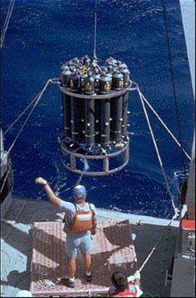
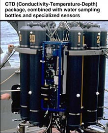
Top: A closeup of the primary tool used to map hydrothermal plumes. A ring of plastic sampling bottles surrounds the CTD. The bottles are closed on command from the ship, usually when a scientist monitoring the sensors sees strong evidence of a plume. The blue frame holds a unique PMEL-developed in-situ chemical analyzer, capable of real-time chemical analyses of iron, manganese, and other plume tracers. Left: Scientists deploy the CTD. Click image for larger view.
Once the plume studies have detected active venting and localized its location, it is the job of specialized seafloor exploration tools to find the actual vents and associated biological communities. Such tools include Remotely Operated Vehicles (ROVs), Autonomous Underwater Vehicles (AUVs), and occupied submersibles (such as Alvin). These vehicles are used to create detailed maps of the vent fields and collect biological, geological, and chemical samples from the seafloor itself. The capabilities and use of these devices are explained in ROVs and AUVs.
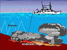
An illustration of a CTD “tow-yo” survey, which creates two-dimensional images of hydrothermal plumes. Click image for larger view and more information.
Exploring the Ocean, Expanding Our Knowledge
Hydrothermal venting can develop on only a minuscule portion of the seafloor, yet its effects influence the entire ocean and support a unique biological community that may be Earth's earliest ecological niche. While we understand many of the basic principles that govern this phenomenon, we remain deeply in the explorative stage of this research. We are surprised almost daily by discoveries of vents where we expected none, chemical compositions that were unpredicted, and the cataloging of new biological species. The ocean is a harsh and unyielding environment, and new progress is hard won. But the excitement and value of increasing our knowledge of one of Earth's basic processes makes this exploration among the most rewarding we can imagine.
Sign up for the Ocean Explorer E-mail Update List.