


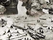
Seasonal encampments and permanent villages were strategically located on shorelines, bays, and at river mouths to take advantage of food resources. Click image for larger view.
Paleoshoreline Research
Robert Steelquist
Education Coordinator
Olympic Coast NMS
Few things are as temporary as footprints on a sandy beach. They are unmistakably human and fleetingly ephemeral—etched in passing and erased with the next wave or high tide. But as with footprints, the steady pounding of ocean waves can reduce built shorelines, roads, cities and civilizations to rubble—a constant reminder of the energy and restlessness of the seas. Oceans, never at rest, transgress the shore with each wave, each tide cycle, and in repeating intervals measured in centuries and millenia.
During the life of our planet, great changes in sea level have occurred. Fossil shells tumble out of mountaintops, and eroded plains appear underwater. In these is the evidence of the ongoing dance between the continents and the oceans, the material cycles of uplift and erosion, and the changing shape of the shores.
Prehistoric Human Migration
We know that in the last 15,000 years—the generally-accepted era of human occupancy of North American coastlines—sea level has varied from more than 100 meters below to as high as 10 meters above the present sea level. Much of this change is the result of climate. When North America was gripped in an Ice Age, water was confined to vast glacial systems resting atop land masses. As the climate warmed, glaciers melted, literally over-filling the oceans and causing the sea level to rise. Other processes affect shorelines as well. “Isostatic rebound” represents the movement of land masses in response to the massive weight of continental glaciers. As glaciers melt and sea level rises, the land rises slightly, unburdened by the ice load.
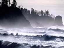
Waves and currents are constantly shaping the coastal environment, presenting particular challenges for finding and interpreting submerged cultural sites. Click image for larger view.
Traditional scientific accounts of human migration to North America are based heavily on the dynamics of sea-level change. When the Bering Land Bridge was exposed, a thousand-mile-wide expanse of green land lay between Asia and North America—a welcoming carpet for ancestors of Native Americans. The conventional wisdom of the land-bridge migration story has held that humans found their way southward into North America via ice-free corridors. They moved quickly as game-hunting generalists who followed their quarry into the grasslands, open valleys and plains in the central part of the continent. Ocean-based cultures, according to this explanation, developed more recently, as people specialized and adapted to maritime climates and marine ecological resources.
Yet, archaeological evidence from North and South America suggests that humans have been in the Americas for perhaps longer than the “ice-free corridor” can safely explain. Estimates of human settlements as old as 30,000 years represent serious challenges to traditional accounts.
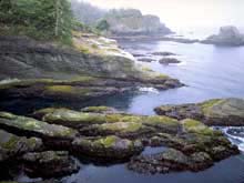
The process of uplift, fluctuating sea levels, and wave erosion is etched on the rocks of Cape Flattery, Washington. Benches visible just above the current waterline represent prehistoric sea level. Click image for larger view.
Recently, another explanation has gained favor—that prehistoric emigrants from Asia arrived by way of the coastlines, as maritime people. If so, then coastal regions—and particularly areas submerged since sea level rise—may bear the archaeological evidence of human occupancy.
The study of paleoshorelines ("paleo" meaning old or ancient) examines the complex intersection of geology, climate, ocean research and archaeology. Scientists must first find ancient coastlines, rivers, estuaries, and floodplains, and then look for signs of people—tools, firepits, middens (refuse heaps, often shells and bones), and remnants or signs of habitations.
Challenges of Paleoshoreline Research
Locating the landforms where humans once lived is difficult, because they are now under water. Assuming that people fished and hunted, and lived in places not too different from the places that they occupied in more recent prehistory, then the submerged landscapes form a starting point for underwater search.
New tools that use various types of sonar, along with powerful computers that arrange the data into pictures, allow us to “visit” and map the ocean floor. Side-scan sonar creates images of structures and objects on the sea floor, both natural and human-made. Multi-beam sonar creates a wide swath of depth readings, which computers transform into high-resolution pictures. Sub-bottom profiling sonar lets us see into the ocean floor itself, penetrating sediments to find their depths and determine their composition. These technologies give us detailed information of the ocean floor, even in water too deep for conventional diving.
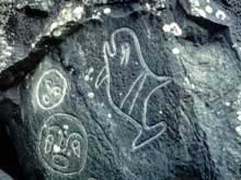
Petroglyphs, or rock etchings, provide a window to the past. Click image for larger view.
The next stage of research involves closer examination of “target” sites. On the shallow continental shelf west of Florida, paleoshoreline sites are accessible by SCUBA divers. In deeper waters off the coast of western North America, other techniques are necessary, including sampling techniques like bottom grabs or coring devices that gather materials for examination on the surface. Remotely-operated vehicles (ROVs) equipped with video cameras represent another way to “visit” these sites.
Artifacts, middens and other signs attributed to human use have been found in rare instances, off the coast of West Florida and in British Columbia's Queen Charlotte Islands. But as rewarding as a true submerged find might be, the practice of archaeology under these circumstances remains extremely difficult.
For example, consider a prehistoric village site discovered on land. Unless disturbed by more recent human activity, stone and bone objects, charcoal, shell fragments, and human constructions like fire-rings or walls retain their physical arrangement as they are gradually enclosed beneath plant life, soil, sand or gravel deposits. An undisturbed site retains its spatial and temporal integrity and, to trained eyes, can tell many stories about its creators and inhabitants.
Imagine the same archaeological site, but subject it to the forces of decades and centuries of wave action, coastal erosion and burial under sediments. In an area of gradual sea-level rise and intense wave energy, the same site would be left in complete disarray—as similar to its original appearance as a fruit smoothie is to a ripe banana. In environments of rapid sea-level rise and low energy, sites would be less damaged.
The study of paleoshoreline archaeology presents many challenges. How do we find likely sites? How do we look for objects that prove human presence? How would we study such a site to learn its story? And how would understanding the bigger picture of prehistoric human presence along the coasts change our thinking about our common past? These are important questions that drive our studies.
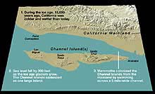
An ancient sea level with altered shorelines. Click image for larger view.
Sea level with current shorelines. Click image for larger view.
But equally important is the recognition that coastlines are always changing. We face perhaps a dramatic shift in sea level within humanity's near future. How will we, like our coastal predecessors, make the necessary ecological and cultural adaptations to survive? What remnants of our own societies will ultimately reside jumbled in the sediments of the continental shelf? How long will our own footprints endure in the sand?
Sign up for the Ocean Explorer E-mail Update List.