


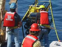
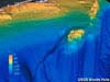
During the sanctuary quest mission, the ROV will be used to “groundtruth” the images that are recorded by the sidescan sonar each evening. Click image for larger view.
Mission Plan
Sanctuary Quest: An Expedition to the West Coast Sanctuaries - 2002
![]() Watch an introductory video describing the objectives for the Sanctuary Quest mission. (mp4, 4.08 MB).
Watch an introductory video describing the objectives for the Sanctuary Quest mission. (mp4, 4.08 MB).
Background
The Pacific coast from southern California to Washington state features vast areas of submerged mountain ranges, canyons, plateaus, volcanoes, basins, rocky outcrops, and pinnacles, many of which have never been surveyed or explored adequately. The region is extremely dynamic, interconnected by a complex mosaic of changeable ocean currents, and large areas that experience periodic upwelling of deep, nutrient-rich cold water. Living and nonliving marine resources in this region are abundant and diverse, and are subject to a wide variety of pressures from natural sources, as well as human activities both on land and at sea.
The Sanctuary Quest expedition will conduct research, exploration, and monitoring activities within and adjacent to the system of national marine sanctuaries within this region. Visual observations, samples, oceanographic data, and survey data will be collected to enhance our understanding of key habitat areas. The expedition will include a significant education and outreach element designed to generate interest in marine research and conservation efforts, provide a foundation for continued collaborative efforts, and address the rich history of exploration throughout the region. Over the long term, the expedition should help provide a framework for understanding more about the efficacy and role of the sanctuary system in protecting and conserving marine resources, and to provide the impetus for continued regional research.
The Expedition
The 2002 expedition will be conducted in three distinct phases. The first phase took place from March 1 to 16. The National Marine Sanctuary Program ![]() conducted a monitoring mission in collaboration with NOAA's Center for Coastal Monitoring and Assessment
conducted a monitoring mission in collaboration with NOAA's Center for Coastal Monitoring and Assessment ![]() (CCMA). The mission collected samples and took oceanographic measurements in support of both site-specific and regional issues. The second or “core” phase will be conducted from April 24 – June 21, starting in the Channel Islands National Marine Sanctuary (NMS) and ending at the Olympic Coast NMS. Efforts during this phase will focus on (1) habitat characterization of discrete areas both within and outside of the system of sanctuaries using a sophisticated remotely-operated vehicle (ROV) provided and operated by the U.S. Navy; (2) discrete investigations of specific submerged cultural resources; and (3) additional monitoring. Information collected using the ROV and survey instruments also will be used to help identify submerged paleoshorelines that may have provided habitat for prehistoric humans. The final phase will include a monitoring transit from Kodiak Alaska to Washington state (Sept. 4-10), and additional survey and monitoring work in the Olympic Coast NMS (Sept. 11-16).
(CCMA). The mission collected samples and took oceanographic measurements in support of both site-specific and regional issues. The second or “core” phase will be conducted from April 24 – June 21, starting in the Channel Islands National Marine Sanctuary (NMS) and ending at the Olympic Coast NMS. Efforts during this phase will focus on (1) habitat characterization of discrete areas both within and outside of the system of sanctuaries using a sophisticated remotely-operated vehicle (ROV) provided and operated by the U.S. Navy; (2) discrete investigations of specific submerged cultural resources; and (3) additional monitoring. Information collected using the ROV and survey instruments also will be used to help identify submerged paleoshorelines that may have provided habitat for prehistoric humans. The final phase will include a monitoring transit from Kodiak Alaska to Washington state (Sept. 4-10), and additional survey and monitoring work in the Olympic Coast NMS (Sept. 11-16).
As with the Sustainable Seas and the Islands in the Stream expeditions, the 2002 investigations will include significant education and outreach efforts. Since missions will be conducted at each west coast NMS, there will be ample opportunity for staging shore-based events, as well as activities such as “Student-at-Sea” events. The program also has recruited a professional videographer who, with a team, will record the work that will be undertaken and prepare high quality video products including “B-Roll,” video “bumpers”, and 1- to 3-minute videos for display in aquariums and other venues.
Phase I
West Coast Monitoring Mission, March 1 – 16
Phase II
Channel Islands NMS, April 24 - May 4
Monterey Bay NMS, May 5 - 14
Gulf of the Farallones NMS, May 16 - 24
Cordell Bank NMS, May 26 - June 5
Olympic Coast NMS, June 11 - 20Phase III
Alaska and Canada Monitoring Transit, Sept. 4 - 10
Olympic Coast NMS, Sept. 11 - 17
The Goals
The overarching goals of the expedition relate to research, management, and public education and outreach efforts at each of the national marine sanctuaries, and to the sanctuary program as a whole. These include:
Research
Increase understanding of physical structures; Increase understanding of distribution of habitat; Increase understanding of distribution of marine species; Increase understanding of species-habitat relationships; Assess change in habitat and species (revisit known survey sites); Examine potential pockets of biodiversity; Increase understanding of representative sites for purposes of extrapolation; and Provide an opportunity for testing new technologies and protocols.
Management
Support existing state MPA initiatives; Meet site-related information needs; Increase opportunities for collaboration among scientists;
Increase communication between scientists and managers; Increase communication among managers at all levels (inter and intra-agency); and Provide an opportunity for applying data to management decisions.
Public Outreach and Education
Increase public understanding of marine resources, the pressures they face, and management response; Increase public awareness of the impact of their actions on habitats and resources; Effect a change in public attitude and behavior toward the marine environment; and Increase public awareness of the sanctuaries and their programs.
The Missions
Channel Islands National Marine Sanctuary [ Apr 24 – May 4 ]

Besides “groundtruthing,” the ROV also will collect images such as this coral found around the Channel Islands. Click image for larger view.
Operations at the Channel Islands NMS will focus on estimating distribution, abundance and species diversity of communities in deep reef areas that are possible candidate sites (e.g., submarine canyons, offshore banks) for marine reserve areas. Goals include (1) determine an optimal site to establish a permanent biological monitoring area; (2) observe behavior of deep reef fauna; and (3) conduct reconnaissance specimen collecting, including collecting several unusual biofilms observed near seeps in the deeper portions at Footprint Reef.
Additional projects include (1) investigating and characterizing nearshore benthic habitats using sidescan sonar, then groundtruthing the data by collecting visual images of the habitat using the ROV; and (2) using the ROV for reconnaissance dives to record the remains of the bulk-carrier vessel Pac Baroness ![]() now lying on the seafloor in 430 meters, 1410 feet of water. The vessel, when lost in 1987, carried a cargo of powdered copper concentrate, so the mission will include sediment sampling.
now lying on the seafloor in 430 meters, 1410 feet of water. The vessel, when lost in 1987, carried a cargo of powdered copper concentrate, so the mission will include sediment sampling.
Monterey Bay National Marine Sanctuary [ May 5 – May 14 ]
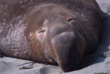
Male elephant seals can reach 15 feet in length and weigh up to 5,000 pounds. (photo: Kip Evans) Click image for larger view.
Efforts at the Monterey Bay NMS will focus on exploring and characterizing habitat in the system of submarine canyons in the vicinity of Point Sur. Recent research in this area indicates geologic activity at the heads of canyons, but not much activity at deeper depths. Scientists hope that this effort will help identify the cut-off point of canyon activity, as well as assess areas that have been proposed for future underwater cable routes.
Another effort involves examining species diversity and abundance of communities within historically trawled and non-trawled areas using an ROV and box cores, and to examine any differences in habitat and species composition. The ultimate goal is to characterize natural resources and historical ecosystems relative to reserves and sanctuaries.
Gulf of the Farallones National Marine Sanctuary [ May 16 – May 24 ]
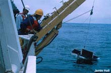
Scientists tow a manta net to collect a sample of organisms that live near the water's surface. (photo: Jamie Hall) Click image for larger view.
Physical and biological investigations will be conducted in a multidisciplinary manner. Researchers will rely on the ROV to collect visual imagery of the benthic invertebrate and fish communities found within the sanctuary and at the adjacent Fanny Shoal. This data will provide baseline information for assessing future changes in community structure if designated no-take fishing zones are established, thus shifting fishing pressure to other locations.
Additional field work will include (1) marine mammal and seabird surveys; (2) investigating vertical and horizontal chlorophyll gradients using CTD casts with fluorometer; (3) research on community composition and abundance of phytoplankton and zooplankton using stratified Tucker trawls, manta nets, and acoustics; and (4) investigating the migratory behavior, distribution and relative abundance of mid-water species using acoustics and net tows.
Another project will complement a recent multi-agency effort to develop a strategy to recover the oil on board the wreck of the Jacob Luckenbach. ![]() This effort will involve using the ROV to conduct a visual survey of the wreck.
This effort will involve using the ROV to conduct a visual survey of the wreck.
Cordell Bank National Marine Sanctuary [ May 26 – Jun 5 ]
The edge of the continental shelf drops off quickly on the west side of Cordell Bank. Click image for larger view.
Physical and biological investigations will be conducted in a multidisciplinary manner. Researchers will rely on the ROV to collect visual imagery of the benthic invertebrate and fish communities found within the sanctuary and at the nearby Point Reyes upwelling center.
Additional field work will include (1) marine mammal and seabird surveys; (2) investigating vertical and horizontal chlorophyll gradients using CTD casts with fluorometer; (3) research on community composition and abundance of phytoplankton and zooplankton using stratified Tucker trawls, manta nets, and acoustics; and (4) investigating the migratory behavior, distribution and relative abundance of mid-water species using acoustics and net tows.
Olympic Coast National Marine Sanctuary [ Jun 11 – Jun 20 ]
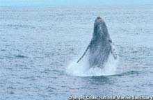
Humpback whales (Megaptera novaeangliae) visit the Olympic Coast NMS during the spring and summer months, congregating to feed over the rich banks off Cape Flattery. (photo: Olympic Coast NMS). Click image for larger view.
Efforts at the Olympic Coast NMS will focus on exploring and video-documenting ancient and undisturbed sea-floor communities, such as deep-water coral and sponge fields, and submerged paleoshorelines that may have once been inhabited by humans. Specific efforts involve collecting video and samples that will be used to identify habitat and species assemblages. Researchers also will look for signs of archaeological evidence of cultural material.
Additional efforts include conducting sidescan sonar operations to continue habitat mapping and characterization efforts, and conducting marine mammal and seabird surveys to assess offshore distribution and abundance. In addition, water samples will be collected as part of ongoing efforts to understand more about the genesis of harmful algal blooms.
Partnerships
The success of this expedition depends on partnerships, which provide an opportunity for scientists, natural resource managers, and educators from many public and private agencies and institutions to collaborate to fulfill a common set of goals and objectives. The following is a list of some of the institutions engaged in this endeavor:
NOAA, National Ocean Service, Office of National Marine Sanctuaries NOAA, National Ocean Service, Special Projects Office NOAA, National Ocean Service, Center for Coastal Monitoring and Assessment NOAA, National Marine Fisheries Service United States Geological Survey United States Navy, Naval Facilities Engineering Services Center University of California Santa Barbara University of California Santa Cruz Monterey Bay Aquarium Research Institute Monterey Bay Aquarium Washington Department of Fish and Wildlife Makah Cultural and Research Center
Sign up for the Ocean Explorer E-mail Update List.