


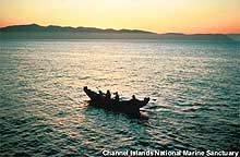
The Chumash, indigenous people who historically lived along the California Coast from Malibu to San Luis Obispo, once harvested the marine resources of the Channel Islands for food and trade. Click image for larger view.
Human Uses and the Sea
West Coast NMS Education Team
Every national marine sanctuary (NMS) on the west coast harbors a rich and varied cultural heritage associated with the sea. Reports prior to 1700 describe the native peoples and cultures, which established early trade routes. European exploration took place from the 1600s to the 1800s and included Spanish mariners, fur traders and whalers. Eventually, settlers arrived and shipping operations ensued. Because ocean conditions are sometimes rough and unpredictable, shipwrecks litter the ocean floor and carry many secrets of the lives that were lost. This essay traces the route of the Sanctuary Quest expedition and spans all five western national marine sanctuaries.
Channel Islands NMS
Recent research suggests that the first peoples to come to the continent of North America arrived at the Channel Islands by boat. Based on radiocarbon dating results, the “Arlington Woman” appears to have lived at least 13,000 years ago on what is now Santa Rosa Island. The oldest skeleton ever found in North America, she lived there during the end of the last ice age, which ended 10,000 years ago.
The early inhabitants of the Channel Islands and the area surrounding present-day Santa Barbara were accomplished shipbuilders. The Chumash, the Gabrielinos, and the Tongva made ocean-faring boats called tomols. These vessels, which measured more than 30 feet long and held up to 12 people, were built from redwood planks sealed with natural substances like asphaltum, a naturally occurring tar found on California's rocky shores. The use of tomols connected the people with the sea and its bounty, and enhanced trade, kinship and interaction with other tribes across California well into the 1700s.
Juan Rodriguez Cabrillo was the first of the European explorers to explore central California. He departed from Guadalajara, Mexico, in 1542 to search for the legendary Strait of Anian, which was supposed to connect the Atlantic and Pacific Oceans. He stopped in present day San Diego Bay and continued northward to Point Conception, going through present-day San Pedro, Santa Monica, San Buenaventura, Santa Barbara and the Channel Islands on the way.
Between 1853 to 1980, more than 140 shipwrecks occurred in the Channel Islands NMS and National Park. The shipwreck remains reflect the diverse range of activities and nationalities that traversed the Santa Barbara Channel. European sailing and steam vessels, California-built Chinese junks, American coastal traders, and a Gold-Rush-era side-wheel steamer have all been lost in these waters. Each has a story to tell about the history, technology and society of earlier times.
Monterey Bay NMS

Southern sea otters are a common sight in the Monterey Bay Sanctuary, despite the fact that the overall population is very endangered. Sea otters use the kelp forests to eat, sleep, mate, and hide from predators. (photo: Kip Evans)
Humans settled in the vicinity of the Monterey Bay NMS at least 10,000 years ago. By the early 1700s, about forty Native American tribes populated coastal areas from San Francisco Bay to Point Sur. The Spanish called the Indians “Costanoans”, meaning “coast dwellers.” Today they are known as the Ohlone, meaning “people of the west.”
The rich ocean harvest in Monterey Bay brought explorers to this area from many nations. The Spanish were the first to arrive in the late 1700s, and founded an extensive network of missions. Monterey was established as the region's capital under Spanish rule, and as a port through which cargoes were certified. The Spanish exported valuable otter pelts gathered by Russian and Indian hunters to Asia, Europe, and the Americas. Whalers from many countries hunted along the central coast in the late 1700s and early 1800s, feeding a voracious demand for oil, baleen and meat.
By the late 1800s, sea otters became scarce around Monterey Bay. The Spanish harvested abalone for trade with northwest coast Indians. In the 1850s, Chinese immigrants settled in Monterey to harvest kelp and to fish for abalone, squid and shark, an industry which helped feed California's burgeoning Gold Rush population. Sicilian fishermen also established a sardine fishery along the central coast of California. The fishery peaked from 1932 to 1947, but it collapsed in the 1950s and has never fully recovered.
More than 250 shipwrecks have been documented in the Monterey Bay NMS. The shallow, rocky areas of Point Lobos, Cypress Point, Point Pinos and Santa Cruz boast the highest number of recorded shipwrecks in the sanctuary.
Gulf of the Farallones

In large groups such as these, Common Murres lay their eggs right on the rock without any nesting materials.
Twenty-seven miles off the coast of San Francisco, the Farallon Islands appear on the horizon like an ocean mirage. These wind-swept islands are a haven for a flourishing population of seals and seabirds. People have long been drawn to the plentiful resources of this area. Costanoans and Coast Miwok Indians lived along the shoreline and relied on the abundance of marine life for sustenance.
When the Europeans arrived, large numbers of seals and seabirds were harvested for fur or food. In the early 1800s, seal furs were harvested and traded with Chinese markets. It was estimated that in one three-year time span, 150,000 seal furs were taken. In 1828, an estimated 50,000 seabirds also were harvested by Russian traders and shipped to Fort Ross. During the Gold Rush era, when the population of San Francisco increased dramatically, thousands of Common Murre eggs were harvested from the Islands.
Today, the Farallon Islands are protected as a wildlife refuge accessible only to researchers who study the seals, seabirds and other marine life. Fishers still can fish in the productive waters of the Gulf of the Farallones NMS for Dungeness crab, salmon, and rockfish, which they sell at markets around the world.
In addition to its abundance, the Farallon Islands and the mainland coast north of the Golden Gate is known to be hazardous to shipping operations. Year-round fogs, dangerous storms and ocean swells often pounded ships. Many shipwrecks litter the ocean floor. The earliest known shipwreck occurred in 1595, when the Spanish Manila galleon, San Agustin, sunk in a gale while anchored in Drake's Bay.
Cordell Bank NMS
For many years, the existence of Cordell Bank was unknown. Nearshore food resources were so plentiful that the native Miwok Indians probably did not venture out to this remote area. Many mariners sailed over it without suspecting its presence. In 1853, George Davidson, a surveyor with the U.S. Coast Survey, was caught in dense coastal fog off Point Reyes. He dropped a lead line overboard, expecting the depth to be more than 60 fathoms (360 ft). Instead, it measured a mere 30 fathoms (180 ft). He correctly guessed that he had found a rocky bank. In 1868, Edward Cordell located the bank again and was recognized for his work when it was named after him.
Although Cordell Bank has been known as a productive fishing ground, little scientific exploration occurred until 1977, when Cordell Expeditions employed SCUBA divers to explore the rocky reef. The divers collected specimens, conducted high-resolution depth surveys, and took thousands of photographs to document the colorful habitat. Cordell Bank received legal protection as an NMS in 1989.
The abundant surface sea life, which first attracted Edward Cordell, still attracts seabird and whale watchers. Many species of pelagic seabird from both the northern and southern hemispheres flock here to feed in the nutrient-rich waters. Cordell Bank remains a destination for recreational and commercial fishers because it boasts abundant rockfish populations. However, the mariners who do venture out to the Bank must contend with its fierce and unpredictable weather conditions.
Today, Cordell Bank NMS staff uses new technologies, including the use of submarines, sonar and remotely-operated vehicles to characterize the area's ecosystem dynamics and unique habitat.
Olympic Coast NMS
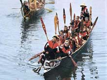
Canoes traditionally built out of rot-resistant cedar have, and continue to be, a vital part of the culture of coastal tribes. Click image for larger view.
The present-day Olympic Coast NMS was once one of the most sought-after pieces of maritime real estate in the world. It was the supposed location for the mythical Strait of Anian—the passage connecting the Atlantic Ocean with the Pacific, and thus to the riches of Asia. Based on an account by Greek pilot Apostolos Valerianos, explorers from England and Spain raced to discover and claim this strategic waterway.
Although Captain James Cook did not find the fabled strait during his 1778 voyage, he did discover sea otters, thus launching a lucrative trade that nearly eliminated the animals from the Pacific. Spanish conquest peaked in 1792 when a fort at Neah Bay was established. Abandoned six months later, the fort was the last created and the first abandoned by the Spanish as their empire began to decline. At the end of the 18th Century, Spanish, English and Russian monarchies were still competing for control over the Olympic Coast. The fledgling United States had also entered the fray.
But before and during the age of European exploration, native communities made up of ancestors of today's Makah, Quileute, Hoh, and Quinault Indians peopled the region. Permanent villages were located close to productive marine areas yielding fish, shellfish, marine mammals and the materials necessary for elaborate trade networks along the coast. So intertwined were these cultures to the coast that social and political standing was derived from family-held rights to specific resources such as whales, mussel beds, and fishing areas.
The combination of fierce weather, isolated and rocky shores, and heavy ship commerce soon rendered the Olympic Coast a graveyard of sorts. More than 180 shipwrecks have been identified in the vicinity of the sanctuary, reflecting the commercial development in the region and its significance to the economies of the United States and Canada. Many ships simply disappeared, their last known location recorded by the lighthouse keeper at Tatoosh Island before they sank into watery oblivion. “Last sighted, Cape Flattery,” is the grim epitaph for many unfortunate ships and crew.
Sign up for the Ocean Explorer E-mail Update List.