


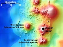
Location map showing East Diamante submarine volcano and the Sarigan submarine volcanoes, as well as the volcanic islands of Sarigan and Anatahan. Click image for larger view.
MR1 Sonar Provides New View of Sea Floor around Mariana Islands
February 17, 2003
Bob Embley
Co-Chief Scientist
Pacific Marine Environmental Laboratory, NOAA
Bill Chadwick
Volcanologist
Oregon State University
The Northern Mariana Islands have all been created by volcanic activity, but until now, only the small portion above the surface of the ocean has been known. The islands represent only a small percentage of the total volume of the mostly submarine volcanoes that rise from a depth of about 3,000 meters (about 1.7 miles).
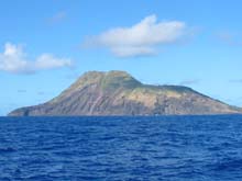
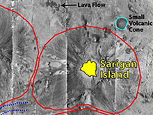
Sarigan Island as seen from the ship, and from the MR1 survey. Click images for larger view.
The images created by the MR1 sidescan sonar during the past few days have mapped out numerous volcanic flows on the submarine portions of the islands and adjacent submarine volcanos, as well as erosional drainage patterns that look like streams on the flanks of volcanos on land.
An excellent example of this terrain is seen in the sonar “mosaic," made up of several overlapping images, of the area adjacent to and west of Sarigan Island. Note the spokelike patterns around Sarigan and the two adjacent submarine volcanoes, West Sarigan and South Sarigan, on the map at top right. The dark ribbons probably represent flows of coarse volcanic debris derived from eruptions at the summits of the volcanoes.
Many of these eruptions are gas-rich and produce fragmental deposits of pumice, scoria and ash. Although more intact lava flows are seen on the flanks of the volcanoes in some places, the overall “message” of this image is the ubiquitous downslope transport of the volcanic byproducts. The summit eruptions and resulting radial pattern of distribution of the volcanic products over time construct classic cone-shaped volcanoes.
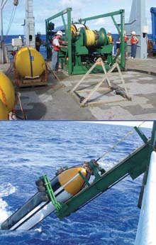
The top image shows the MR1 sonar system just before deployment. The large green structure is the Launch and Recovery System. The bottom image is the towfish being recovered after a successful 2.5 day survey. Click image for larger view.
In addition, material from some of the larger flows continues further downslope and is transported through deep-sea channels formed between the volcanoes and westward into the deeper basin.