


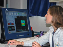
"Watchstanders" monitored the incoming EM300 raw multibeam data for quality continuously in shifts of 4 hours on/8 hours off. Click image for larger view and image credit.
Surprise Finding at an Unusual Site
December 5, 2005
Scott White
Marine Geologist and Project Co-PI
After a 36-hour steam from 89.5oW to 94.5oW longitude, the EM-300 multibeam survey has been completed and the results are trickling in. A number of “watchstanders,” and I have been monitoring the incoming raw data for quality continuously in shifts of 4 hours on/8 hours off. We have now processed the information and created bathymetric maps showing us the topography of the seafloor. What do the maps reveal to us about the terrain and geology of the region? The results were unexpected.
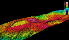
The recently collected EM-300 data revealed these two back-to-back calderas. The calderas were initially discovered in 2003 by K. Hoernle,(PI, IFM-Geomar, Kiel), R. Werner (Chief Scientist, IFM-Geomar, Kiel), D. Christie (OSU) and colleagues (Christie et. al, 2005). Although the calderas had been previously discovered, they were never named. Click image for larger view and image credit.
Our EM-300 survey area was determined based on previously acquired, lower-resolution bathymetric maps produced several years ago. While these maps provided enough information to give us the ridge-crest location and a general sense of the geomorphology (shape of the seafloor), they were too coarse to tell us much about the way the ridge had formed. Our EM-300 survey ran along the ridge crest and collected data averaging the depth over 50 square meters, providing 4 times greater resolution than previous surveys. This detail is important for planning the near-bottom surveys that will happen during the rest of the cruise, but also gives us new information about the way these seafloor-spreading volcanoes are built.
This area is a rare combination of different styles of spreading-ridge topography, ranging from a deep “rift valley” to a shallow, along-axis topographic ridge called an “axial high.” One of the unusual things about it is that part of the ridge looks like a fast-spreading ridge, although it is formed at an intermediate spreading rate (5 cm/yr). Fast-spreading ridges have an “axial high” formed by the buoyancy of hot rock below the ridge that results in a smooth broad ridge crest covered by low, sheet-like lava flows. Looking at this area with 4 times greater resolution reveals that the shallow “axial high” differs in shape from that seen at fast-spreading ridges.
The new EM300 data collected shows a bumpy axial high suggesting that it is built from many small eruptions. Volcanic cones up to 200 meters high (the same height as a 30-story building) occur on top of the ridge. Our new data along the Galapagos Spreading Center permit us to see for the first time that faults along the ridge crest split volcanoes and open small valleys in the ground. In one place, two calderas occur back-to-back. These observations lead me to propose the hypothesis that the “axial high” on the Galapagos Spreading Center may have been built up from many individual lava flows, and is elevated largely because it is a pile of volcanic material on the seafloor, much like a seamount. In the days to come, as we collect new data and integrate it with the EM-300 maps, we will be evaluating the merits of this new hypothesis.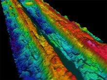
This bathymetric map created using the EM-300 multibeam sonar shows the ridge crest at 4 times greater resolution than previous maps. Seeing the ridge in greater detail enhances our ability to interpret the geological processes that contribute to shaping the ridge. Click image for larger view and image credit.
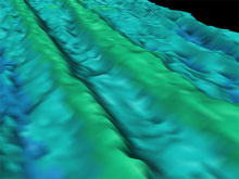
This low-resolution bathymetric map shows us the average seafloor depth of a 200m square area. Although the map provides us with a general idea of large seafloor features, there is not enough detail to conclusively describe the geomorphology of the region. Click image for larger view and image credit.
While much new information has come to light, many new questions have been raised by the new data. What is the nature of the volcanic eruptions on the crest of the ridge where the spreading axis builds an “axial high”? How does the distribution of individual faults and fissures created by plate separation due to seafloor spreading differ at rift valleys and axial highs? What will be the relationship between the shape of the ridge and hydrothermal vent locations? During the rest of the cruise, we will be searching for the answers to these questions.
Fast Fact
Did you know that the mantle plume “hotspot” beneath the Galapagos Islands and Galapagos spreading center has been erupting lava onto the sea floor episodically for approximately 20 million years?
Sign up for the Ocean Explorer E-mail Update List.