


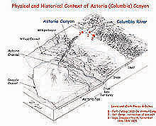
Had Lewis and Clark made their expedition at a time of lower sea levels, their journey along the Columbia River could have taken them to the edge of Astoria Canyon. Their westward push, however, stopped 10 mi short of the canyon at Fort Clatsop, where the modern-day mouth of the Columbia meets the Pacific Ocean. Click image for larger view.
Mission Plan
Historic Context
In 1803, at the request of President Thomas Jefferson, the U.S. Congress authorized the exploration of lands west of the Mississippi River in what would become one of the most storied chapters of American exploration. Led by Jefferson’s secretary, Meriwether Lewis, and Lewis’ friend, William Clark, the party of 33 individuals, dubbed the Corps of Discovery, made its historic crossing of what is now the western United States between 1804 and 1806, ending its journey where the mouth of the Columbia River meets the Pacific Ocean. This first organized exploration of the American West was marked not only for its bold thrust into the unknown, but also for its scientific return. Descriptions of hundreds of plants and animals previously unknown to science are a lasting legacy of the famous expedition. Learn more about this historic 19th century expedition.
One area of the North American continental platform, however, remained inaccessible to the Corps of Discovery. This was the continental shelf and slope beneath the Pacific Ocean. Now, 200 yrs later, exploration in the spirit of Lewis and Clark will resume in a submarine canyon during the summer of 2001, during an expedition befittingly named the Lewis and Clark Legacy. Beginning just 10 mi west of the present mouth of the Columbia River, a corps of ocean explorers will map, probe, and document physical and biological systems in the depths of Astoria Canyon, the westernmost portion of the Columbia River drainage system, and on Heceta Bank, a nearby underwater plateau. Today, due to its depth and inaccessibility to commercial and sportfishing, the canyon is a virtually unexplored biological haven, and thought to be a refuge for fish and unusual invertebrate communities.
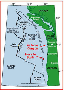
The locaction of Astoria Canyon and Heceta Bank in relation to major geologic features of the northeast Pacific Ocean. Click image for larger view.
Modern Context and Need for the Expedition
Large decreases in both fish and invertebrate communities around the world have deepened anxiety about the long-term health of sea-floor ecosystems. This concern is heightened by the likelihood that human activities may be responsible for a large portion of the problem. The true human impact on the extent of these declines is unknown, however, because in many areas, exploitation by commercial interests preceded exploration by the scientific community. A major difficulty in studying and monitoring many easily accessible sea-floor habitats is their already disturbed conditon. A new thrust in ocean exploration can have a positive impact on this situation because there is a good chance that certain ecosystems off of the U.S. West Coast, such as Astoria Canyon, are relatively undisturbed due to their remoteness and/or rough bottom characteristics. It is ironic that even after more than 40 yrs of ocean research off the West Coast of the United States, many places remain virtually unexplored by modern technology. During the summer of 2001, the marine habitats of Astoria Canyon, a relatively "neglected" major submarine province, will be a focus of ocean exploration in the Northeast Pacific Ocean.
Francis Shepherd, an early pioneer of marine geology, first described Astoria Canyon in the 1930s. Initially called the Columbia Canyon, its name was changed to Astoria Canyon on an early map, and this became its official designation. Little research has been done on the canyon since the 1960s and early 1970s, when scientists at Oregon State University and the University of Washington initially described its sediments, water movements, and biology.
Overview of the Expedition
The Lewis and Clark Legacy Expedition will be conducted in three phases. Phase 1 is detailed mapping of Astoria Canyon. Phase 2 is exploration of the canyon’s geological and biological features using remotely operated vehicles (ROVs). Phase 3 is exploration of the habitats and fisheries of Heceta Bank, a heavily fished submarine plateau on Oregon’s outer continental shelf. The goals of the expedition are to:
- produce a detailed map of Astoria Canyon to 2,000 meters depth;
- identify the canyon’s major geologic provinces and unusual features, such as seeps, recent landslides, and unusual ecological systems;
- sample and preserve representative elements of the canyon’s biological and geological features;
- translate the excitement of exploration of a submarine canyon to the public and educational communities;
- compare fish and invertebrate populations found in similar habitats in Astoria Canyon and Heceta Bank; and
- report on the major results of these explorations.
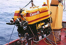
The ROV ROPOS will make 15-20 dives, each lasting from 12 to 18 hrs, during the expedition. Some will extend to 2,000 m depth. Click image for larger view.
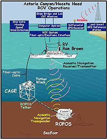
Schematic image of ROV deployment and support equipment. (Drawing is not to scale.) Click image for larger view.
Uncharted Territory: Mapping Astoria Canyon, May 29 – June 16 (Phase 1)
The first phase of the expedition was a detailed sidescan sonar survey of the upper portion of Astoria Canyon from the continental shelf break down to a depth of about 2,000 meters. Previously available sonar data provided an excellent overview of the canyon’s geologic features and a baseline for more detailed studies. Deep-towed sidescan sonar, however, will provide the higher-resolution imagery necessary to identify in greater detail the rock outcrops, possible methane seeps, and unusual features, such as submarine sediment slides, that will be targets for ROV exploration of the canyon during Phase 2. The Phase 1 survey used a chartered, deep-towed sidescan and bathymetric mapping system on the vessel Auriga, which sailed from the port of Seattle, WA.
Visiting the Frontier: Diving into Astoria Canyon, June 26 – July 3 (Phase 2)
Phase 2 consists of a series of dives using the ROV named ROPOS, the deployment of instruments to measure physical and chemical characteristics of the waters of the canyon, biological sampling through the use of sonar and trawls, and hydroacoustic monitoring of biological and geological sounds in the canyon. The ROV dives will cover approximately 40 kilometers along the upper part of the canyon, over a range of depths from 200 to 2,000 m (650 to 6,560 ft). Each dive will give scientists a chance to "visit" the canyon using a network of cameras, instruments and sensors mounted on the ROV. By looking into never-before-seen areas along the canyon walls, the scientists will see the fish and other marine life there, note how ecosystems are arranged at different depths, and gather information concerning the chemical and physical properties of the water and sea floor.
ROPOS will make approximately 15-20 dives, each taking from 12 to 18 hrs. Allowing for the rough terrain and the time needed to collect samples, about 15 straight-line routes (transects) will be probed over the canyon walls and floor. Acoustic data collected by hydrophones in the area prior to and during the summer of 2001 will be analyzed, and all detected biological and geological sounds, such as fault movement, mass wasting, and whale and fish vocalizations, will be located and identified as possible exploration sites for ROPOS. Portions of ROV transects will follow the guidelines developed for habitat-based studies of fishes and invertebrates with ROPOS on Heceta Bank. This will permit a direct comparison between the Astoria Canyon and Heceta Bank areas, and also contribute to the development of a growing database of habitat-specific abundance measurements for fishes and invertebrates along the Pacific Northwest coast.
To monitor oceanographic conditions during ROV dives, the team will measure conductivity, temperature, and depth with CTD casts, and optical and chemical sensors will be deployed to measure chemical constituents in the water. The data from these casts will define the distribution of dissolved and particulate materials (e.g., nutrients, methane, organic matter) that can affect the health of organisms living on the canyon floor. To understand how these materials are transported through the canyon, the team will deploy two moorings with sensors to monitor current flow, particulate matter concentrations, and nutrient concentrations. These measurements will be used to assess the oceanographic conditions under which biologically important materials move up or down the canyon.
Exploring for large groups of fish and zooplankton will be conducted through straight-line acoustic sampling across the canyon using a towed echosounder or multibeam sonar. The accuracy of these acoustic transects will be established using two types of trawls. Small, nonswimming organisms that move primarily by ocean currents will be sampled with a towed midwater depth trawl. Free-swimming organisms will be sampled through the use of a rope trawl towed by a commercial fishing vessel, the F/V Sea Eagle.
All expedition activities during Phase 2, with one exception, will be staged from the NOAA Ship Ronald H. Brown, sailing from the port of Vancouver, British Columbia.
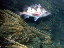
This dark-blotched rockfish, photographed at a depth of over 1,000 ft, represents one of six rockfish stocks along the U.S. West Coast that have been declared overfished. The expedition hopes to learn more about the habitat of these species. Click image for a larger view. Click image for larger view.
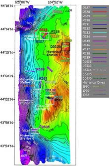
High resolution, side-lit multibeam bathymetry of Heceta Bank. Click image for larger view.
Comparing Underwater Realms: Exploring the Habitats of Heceta Bank, July 4 – July 13 (Phase 3)
The final phase of the Lewis and Clark Legacy Expedition will be to gather data on Heceta Bank from transects with ROPOS. Specifically, ROPOS will repeat historical transects of Heceta Bank from the 1980s, will also repeat transects from the summer of 2000, will conduct new transects to cover the entire geographical range of the bank, and will collect biological and geological samples. Phase 3 activities will be staged off the NOAA Ship Ronald H. Brown.
This phase is being conducted in cooperation with an ongoing, comprehensive study of the habitats of Heceta Bank, which is using state-of-the-art survey strategies, instrumentation, and data analysis. In 1998, an interdisciplinary group of scientists from federal, state, and academic institutions initiated this study of groundfish populations and habitats on and near the bank, which is the largest and most important of the heavily fished rocky banks on the outer continental shelf off Oregon. Heceta Bank was the site of 58 submersible dives in the late 1980s, which characterized the bank's species composition and provided important data on the relationship between fish species and bottom types. The acquisition of a state-of-the-art, high-resolution sonar survey at the site in May 1998 provided a highly detailed, precisely navigated sea-floor map of bathymetry (depth) and sea-floor texture, which serves both as a context for the 1980s data and as a basis for the current, comprehensive study of groundfish/habitat relationships over a larger area. Learn more about past and ongoing studies of Heceta Bank fisheries.
The current study is combining the new survey data, the historical data, and additional sea-floor surveys in 2000 and 2001 to address the following questions: (1) At what scales are there quantifiable relationships between groundfish populations and sea-floor morphology/texture? (2) What are the factors that control these relationships? (3) What changes may have occurred in the fish populations after a decade? and (4) What are the characteristics and extent of natural refugia?
By reexamining the habitats of Heceta Bank and sampling its fish populations, the Lewis and Clark Legacy Expedition will be able to compare the habitats and fish and invertebrate populations of Heceta Bank with those found in Astoria Canyon.
Fishery biologists anticipate that this information will lead to: (1) a more quantitative approach to mapping essential fish habitat for the U.S. Exclusive Economic Zone; (2) a model approach for characterizing and quantifying habitat associations of bottom-dwelling animals on a scale meaningful to the stock assessment of commercial species and the conservation of benthic communities; and (3) the opportunity to examine the possible impact of a decade of intense bottom fishing at a critical place on the outer continental shelf of the northwestern United States.
The Web team gratefully acknowledges this contribution by the Lewis and Clark Legacy Expedition team.
Sign up for the Ocean Explorer E-mail Update List.