


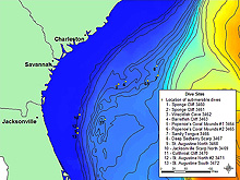
This map displays the 13 sites on the Estuary to the Abyss Expedition dive schedule. Click image for larger view.
Estuary to the Abyss: Exploring Along the Latitude 31-30 Transect
August 20 - September 1, 2004
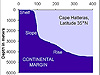
The diverse ocean-bottom habitats off the coast of South Carolina and Georgia support a corresponding diversity of organisms. An imaginary line, or transect, running from the coast of Georgia to the edge of the continental shelf off South Carolina would cross these habitats: coastal sands washed down from the land; emergent, hard-bottom, rocky outcrops on the continental shelf; the soft muddy sediments on the upper Florida-Hatteras Slope; and the complex bottom topography of the Charleston Bump on the Blake Plateau. Beyond the Blake Plateau lies the deep ocean, or the abyss.
The waters overlying the transect change as well. They become increasingly less influenced by local climate and runoff from the land, and more influenced by tropical currents of the Gulf Stream, as you move offshore.
Scientists on the Estuary to the Abyss Expedition will research the habitats and fauna along this line, which we refer to as the "Latitude 31-30 Transect." Sponsored by the NOAA Office of Exploration, the expedition team will work aboard Harbor Branch Oceanographic Institution's research vessel, the Seward Johnson, which carries and deploys the deep submersible vehicle, the Johnson-Sea-Link II.
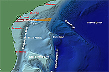
The Latitude 31-30 Transect extends from the Georgia coast to the deep sea. Scientists on the Estuary to the Abyss Expedition will study marine life in deeper waters along the transect (marked in orange) to complement previous studies of shallow-water faunas. Click image for larger view.
For nearly a half-century, fishery scientists and marine ecologists have conducted research and monitoring of many of the near-shore marine and estuarine habitats off the coast of the southeastern U.S. Historically, most of these research efforts have been aimed at waters inshore of the Florida-Hatteras Slope, where productive shelf waters support important fisheries for snappers, groupers, and other reef fishes. The deeper waters beyond the Florida-Hatteras Slope have been studied less.
The Estuary to the Abyss cruise will concentrate on deeper waters (those greater than 400 m) along the transect. Our research will complement previous studies of shallow-water faunas. We will examine changes in faunas that occur with increasing depth and distance offshore.
The exploration along this transect will also help us understand the influence of several variables -- including distance from land (and its human inhabitants), bottom type, and overlying water masses -- on the assemblages of organisms that dwell on the bottom.
Overall, we will expand our knowledge of bottom faunas from the estuary to the deep sea.
Updates & Logs
Click images or links below for detailed mission logs and updates.

 August 30, 2004 The
sea-floor habitats of Blake Plateau vary from sediment-starved
rock pavement, to terraced and vertical cliffs of inter-bedded (multi-layered)
rocks, to enormous rippled dunes.
August 30, 2004 The
sea-floor habitats of Blake Plateau vary from sediment-starved
rock pavement, to terraced and vertical cliffs of inter-bedded (multi-layered)
rocks, to enormous rippled dunes. August 29, 2004 How many habitat types exist along the southeastern U.S. coast? Learn about the five different habitats in today's log.
 August 28, 2004 Field vs. the lab: the graduate students'
perspective is revealed.
August 28, 2004 Field vs. the lab: the graduate students'
perspective is revealed. August 27, 2004 The
Johnson-Sea-Link II finds
and collects Shaefer's
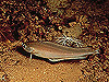
anglerfish. This species -- Sladenia
shaefersi -- has been seen only three times!
August 27, 2004 The
Johnson-Sea-Link II finds
and collects Shaefer's
anglerfish. This species -- Sladenia
shaefersi -- has been seen only three times!


 August
23, 2004 What's the best way to photograph
live specimens not underwater? Learn about the
Joys and Challenges
of “Underwater” Photography.
August
23, 2004 What's the best way to photograph
live specimens not underwater? Learn about the
Joys and Challenges
of “Underwater” Photography.
 August 21, 2004 A thunder storm erupts, and the crew waits out the rain and lightning before launching the Johnson-Sea-Link II. On this first dive, the crew deploys a CTD and two nets to collect plankton, and samples sponges.
 August 20, 2004 The members of the Estuary to the Abyss Expedition embark from Harbor Branch Oceanographic Institution aboard the R/V Seward Johnson.