


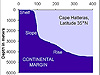


The Estuary to the Abyss Expedition, along the Latitude 31-30 Transect, will expand upon samples (shown above) taken earlier by members of this expedition team. The current expedition will extend this transect out to 2,000 m depth, using a variety of sampling gear. Click image for larger view.
Marine Research in the South Atlantic Bight: Exploring Along the Latitude 31-30 Transect
George Sedberry
Chief Scientist
The continental shelf off the southeastern U.S. is known as the "South Atlantic Bight." It stretches from Cape Hatteras and Diamond Shoals off North Carolina, past the cuspate coastline and broad shelf of the Carolinas and Georgia, and down to the origins of the Gulf Stream north of the narrow Florida Straits at Cape Canaveral. For half a century, fishery scientists and marine ecologists have conducted research and monitoring of continental shelf and nearshore habitats and have closely studied the interaction of productive coastal waters and associated marine life on the bottom.
The offshore waters of the region were relatively unexplored until the second half of the twentieth century, when vessels of the U.S. Bureau of Commercial Fisheries (a predecessor agency to NOAA) began exploratory commercial fishing in the 1960s. Interests in petroleum exploration in the 1970s led to additional studies aimed at further describing habitats and assemblages of algae, invertebrates, and fishes associated with hard- or live-bottom reefs of the continental shelf.
NOAA Fisheries ![]() and the South Carolina Department of Natural Resources (SCDNR)
and the South Carolina Department of Natural Resources (SCDNR) ![]() have continued to monitor
fish populations on the shelf off the southeastern
coast, and NOAA's Center for Coastal Environmental Health and Biomolecular Research (CCEHBR)
have continued to monitor
fish populations on the shelf off the southeastern
coast, and NOAA's Center for Coastal Environmental Health and Biomolecular Research (CCEHBR) ![]() has
conducted additional research and monitoring on invertebrate
communities. The
bight is home to one of the 14 National Marine
Sanctuaries; and Gray's Reef National Marine Sanctuary
has
conducted additional research and monitoring on invertebrate
communities. The
bight is home to one of the 14 National Marine
Sanctuaries; and Gray's Reef National Marine Sanctuary ![]() continues to be a focus of reef research
conducted by NOAA Sanctuaries
continues to be a focus of reef research
conducted by NOAA Sanctuaries ![]() , SCDNR
, SCDNR ![]() , CCEHBR,
, CCEHBR, ![]() and
other agencies and universities in the South Atlantic
Bight region.
and
other agencies and universities in the South Atlantic
Bight region.
Previous research has concentrated on shallow, productive coastal waters
and reefs of the continental shelf, such as Gray's Reef ![]() . These are historically important fishing grounds, and
much of the research has dealt with sustainable fisheries. With
improved vessels, technology, and skills, fishermen have moved farther
offshore into deeper grounds, such as the upper continental slope and
the Charleston
Bump.
. These are historically important fishing grounds, and
much of the research has dealt with sustainable fisheries. With
improved vessels, technology, and skills, fishermen have moved farther
offshore into deeper grounds, such as the upper continental slope and
the Charleston
Bump.
Recent NOAA Ocean Exploration expeditions and other research in the region have focused on the Charleston Bump, a bottom feature that influences the flow of the Gulf Stream, enhances productivity, and is an important fishing ground for pelagic swordfish and other highly migratory fishes. New fisheries have emerged for bottom fish on the Charleston Bump, and fisheries research has been directed at managing these new species. Areas of the ocean offshore of the Charleston Bump, however, are virtually unexplored.
Beyond the edge of the Florida-Hatteras slope, relatively little is known of the communities of bottom-dwelling organisms that live on hard- and soft-bottom habitats of the Blake Plateau, a relatively flat plateau that extends from the Florida-Hatteras Slope to the edge of the abyss at the Blake Scarp. The organisms that live out there must deal with strong currents, hard bottom, and poor food supply. They probably have special adaptations for dealing with this rigorous habitat.
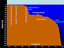
A bottom profile along the Latitude 31-30 Transect. As one heads east (decreasing longitude), there are several types of hard-bottom habitat, including inner- and mid-shelf live-bottom reefs (such as Gray's Reef), shelf edge reefs, and rugged hard-bottom reefs of the Blake Plateau (such as the Charleston Bump). Click image for larger view.
Exploring Along a Transect
Marine habitats from the coastline of the southeastern states to the
edge of the continental shelf are influenced by terrestrial runoff and
climate, with some influence from the Gulf Stream flowing up from the
south. With increasing distance from shore, the influence of the
land mass becomes less important and the Gulf Stream begins to have a
significant effect on the physical conditions on the bottom and in the
water column.
The “Latitude 31-30” theme of the Estuary to the Abyss cruise focuses research, education, and management along a belt transect at 31°31'North latitude, an area which has been extensively sampled in depths less than 400 m. This "transect," or line, runs east along the sea floor from the coast of Georgia to the inner edge of the abyss off South Carolina (at a depth of 2,000 m). It then crosses over coastal sands washed down from the land, emergent hard-bottom rocky outcrops on the continental shelf, soft muddy sediments on the upper Florida-Hatteras Slope, and complex bottom topography of the Charleston Bump on the Blake Plateau. Beyond the edge of the Blake Plateau is deep ocean, or the abyss.
The diversity of ocean-bottom habitats along this transect should support a high diversity of marine life. In fact, biodiversity at shelf-reef habitats, such as Gray's Reef, is quite high. Unfortunately, the deeper parts of this transect are relatively unexplored.
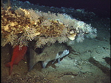
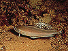
Complex habitats of the Blake Plateau, such as those on the Charleston Bump, provide substrate for a diversity of attached invertebrates and shelter for large fishes, such as the red bream and wreckfish. Click image for larger view.
Mission objectives
Investigators on the Estuary to the Abyss Expedition will expand upon
existing sampling and surveys conducted along the Latitude
31-30 Transect, by extending the transect down onto the continental
slope and the Blake Plateau. We will explore the diverse habitats and species assemblages along the deep end of the transect. Our research will build upon shallow-water data (10-400 m) previously collected
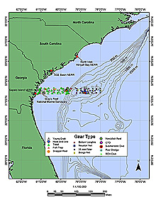
in a variety of habitats, some of which lie in existing and proposed Marine Protected Areas ![]() .
.
Our exploration sites include Charleston Bump, an important deep-water reef. Additionally, we will explore areas beyond those we visited during previous expeditions. We will examine the effects of habitat, management, terrestrial runoff, oceanographic features, and physical gradients on faunal assemblages, ranging from bacteria to fishes. Several research programs along the Latitude 31-30 Transect offer an opportunity to coordinate discovery, research, education, and conservation in an expanded deep-water exploration. We will use the data we collect during this expedition to determine faunal change and human impact along a gradient of increasing depth and increasing distance from land, combined with variable hydrography and bottom complexity.
We will use submersibles, dredges, nets, and associated oceanographic and photo-documentation gear to describe diverse habitats, features, oceanography, and faunal assemblages. We will compare faunas from sheltered and unsheltered habitats, different substrates and different hydrographic regimes. We will also examine the effects of both gradual and abrupt habitat change on associated faunas. (An example of gradual change would be a gradual depth increase; an example of an abrupt change might be a transition from sand to rock substrate.)
Mission activities
The mission will include the following activities:
1.) Mapping with sonar the features on the Florida-Hatteras Slope, Charleston
Bump, and Blake Plateau.
2.) Exploring unique habitats in a research submersible and describing habitats and faunal assemblages in depths ranging from 500-900 m. Data collected during this effort will be compared to existing shallow-water databases and to similar studies conducted both closer to and farther from shore.
3.) Observing and sampling faunal changes along a transect from 500-2,000 m depth, using a research submersible that can dive to 900 m and other sampling gear in deeper water. We will relate the observed faunal changes to changes in depth, increasing distance from land, changes in substrate, and transitions to different hydrographic regimes. This will provide data for comparison with previous sampling in shallower (10-550 m) water.
4.) Collecting new and unusual species for taxonomic and life history studies and for educational purposes, using the submersible (to 900 m) and dredges and small trawls (to 2,000 m).
5.) Collecting samples to examine impacts of antimicrobial resistance in the marine realm.
6.) Collecting samples from corals, mollusks, decapods, and other organisms to elucidate patterns of recruitment and growth (by looking at ages, growth rates and population genetics).
7.) Developing educational materials from the research.
We will use a variety of new and old technological tools, including a research submersible, with its various collecting devices; small dredges and trawls; and plankton nets. We will also use some microbiological methods for obtaining bacteria cultures from fishes to examine antimicrobial resistance. We have selected 20 dive sites, based on historical bottom-sounding maps of the area, that indicate interesting features such as holes, ridges, and corals. The historical maps are based on sparse data, so we will use the ship's sonar to further identify dive sites that have complex bottom topography -- sites which are likely to have diverse habitats and organisms.