


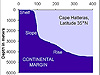


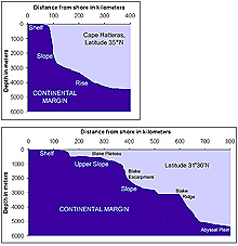
Figure 1: A typical continental margin profile found at latitude 35ºN (a) is significantly different from that of latitude 31º 30’N (b). Both profiles are drawn using the same scale. Click image for larger view.
A Profile of the Southeast U.S. Continental Margin
Leslie R. Sautter
Department of Geology and Environmental Geosciences
College
of Charleston
Since August of 2001, we have explored the continental margin of the Southeast coast of the U.S. in research submersibles. These Ocean Exploration expeditions have taken us from 60-meter-deep ledges with abundant sea life to sparsely populated rocky bottom “seascapes” at depths greater than 600 m.
The Estuary to the Abyss Expedition takes us to these depths and beyond, as we explore the transitions in sea-floor habitat, moving deeper and farther away from shore. We will approximately follow the 31° 30'N line of latitude (referred to during this mission as the "Latitude 31-30 Transect”) across a segment of the continental margin.
The continental margin
The continental margin is the underwater portion of
a continent that extends from the shoreline to water depths of nearly
5,000 m. Continental margins are typically comprised of three regions: the shelf, slope, and rise. Each
region has distinctly different characteristics, because of its distance
from shore, water depth, and steepness. In the Atlantic Ocean, continental
margins have a shelf that is broad and flat and reaches a depth of 100
m. The slope is the steep transitional area between the shelf
and rise, and it lies between depths of 100 and 2,500 m.
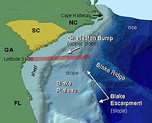
Figure 2: The continental margin off Cape Hatteras, North Carolina, is a classic shelf-slope-rise sequence, while most of the southeast U.S. continental margin is terrace-like, with prominent features such as the Blake Plateau, Blake Ridge, and Blake Escarpment, as well as the Charleston Bump. The Latitude 31-30 Transect is indicated by the red area.
The continental margin off Cape Hatteras, North Carolina (at 35° North latitude) displays the typical Atlantic Ocean shelf-slope-rise sequence (Fig. 1a). Off the Georgia/South Carolina coast, however, the continental margin is anything but typical. Figure 1b shows a cross-section, or vertical “profile,” of the 31°-30' North latitude line. The wide, flat, and shallow shelf stretches 145 km from the shore to a water depth of 100 m.
The Blake Plateau
Moving farther away from shore, between 145 and 170 km, the water
depth drops rapidly to 500 m. This marks the beginning of the Blake
Plateau, a broad, relatively flat portion of the upper continental
slope (Fig. 2). The Charleston
Bump is an area of rugged bottom topography on the relatively
flat Blake Plateau.
The Blake Plateau gradually descends to approximately 1,000 m deep at
its edge, which is about 375 km from the shore.
Beyond the plateau, the sea floor becomes very steep at the Blake
Escarpment,
a prominent geologic feature that runs along the edge
of the continental margin. At 31°30' North latitude, the escarpment’s
descent to the deep ocean basin is interrupted by another prominent feature,
the Blake
Ridge which extends eastward along the "latitude 31-30" line
to 600 km from shore, where it then drops to
the abyssal plain at 5,000 m water depth. An interesting feature
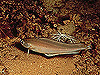
on the Blake Ridge is the presence of methane gas hydrate ![]() seeps.
seeps.
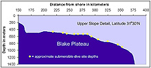
Figure 3: A detail of Figure 1b illustrates the approximate dive site depths along the Blake Plateau planned for the expedition. Dives will range in depth from 450-900 m. Click image for larger view.
Millions of years in formation
This unusual continental margin profile is the result of millions of
years of geologic formation and transformation. Previous studies suggest
that over many millions of years the entire plateau has subsided, or "sank," from
much shallower depths, in part due to the widening
of the North Atlantic Ocean. This subsidence explains the terrace-like
profile.
On the Estuary to the Abyss Expedition, we will concentrate our dive efforts on the Blake Plateau in the vicinity of latitude 31-30 (Fig. 3). This portion of the Blake Plateau has many hills and depressions. The bottom is complex, because it has been eroded by rocks and sediments that are carried by the swift Gulf Stream current. We hope to dive in areas with a variety of sea-floor types – some with hard substrate or rocky bottom, others with soft sediments, and possibly a few with coral mounds. Planned dives range in depth from approximately 450-900 m. These dive sites include the southernmost portion of the Charleston Bump, where we made numerous dives in September 2001 and August 2003. We expect strong currents in this region, because the plateau lies directly beneath the Gulf Stream.