


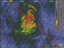
The colors on this reflectivity map describe the hardness of the sea-floor surface. Blue represents soft bottom, such as silt or mud, which is the most common bottom type in the Gulf of Mexico. Scientists on Expedition to the Deep Slope are primarily interested in the yellow and red areas, the hardbottom. Click image for larger view and image credit.
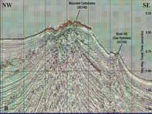
This sub-bottom profile shows a fluid and gas expulsion site with a highly reflective sea floor. The red area on top of the mound exhibits the high reflectivity characteristic of hardbottom areas. The "veins" converging near the peak of the mound provide pathways for the movement of fluid and gas to the sea-floor surface. Click image for larger view and image credit.
Deep-sea Detectives
May 8, 2006
Jeremy Potter
NOAA Ocean Exploration
26° 28.33 N
086° 32.59 W
We are currently halfway through the 36-hr transit to our first site. Despite the flurry of activity over the past few days leading up to our departure, preparations for this expedition started in the fall of 2005. That is when Harry Roberts assembled and began analyzing sea-floor information that could provide hints about the locations of new seep and hard-ground communities in the deep Gulf of Mexico. In order to narrow-down the list of potential targets, he focused on three very different sources of information.
Harry spent most of his efforts reviewing an extensive collection of remotely sensed geophysical data and maps of the sea floor made available by the Minerals Management Service (MMS). Bill Shedd and Jesse Hunt, both from MMS, and Harry studied sub-bottom profiles and surface reflectivity maps that combined data from hundreds of the oil and gas industry's surveys, representing an investment on the order of hundreds of millions of dollars. Harry, Bill, and Jesse searched the data for evidence of fluid and gas escaping from the sea floor. These are the places scientists believe we are likely to find chemosynthetic and hardbottom communities.
Harry supplemented that information by poring through data on thousands of sediment cores collected over the years by James Brooks’ group. Any sediment cores that were known to contain oil provided the possible locations where hydrocarbon seepage occurs. Since seep communities require hydrocarbons to survive, the scientists figure that if you find the hydrocarbons, you will likely find the animals.
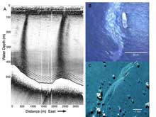
A sub-bottom profile image of bubble plume rising from the sea floor (shown in the left image). An aerial photo of oil slick on sea surface (top right). A space shuttle photo of oil slicks on the sea surface (bottom right). Click image for larger view and image credit.
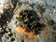
These small oil droplets have seeped through the sediment and adhered to the top of methane hydrate. This image was taken at a depth of less than 1,000 m in the Gulf of Mexico. Click image for larger view and image credit.
Next, Harry and Ian MacDonald perused satellite images of persistent sea-surface oil slicks in the Gulf of Mexico. Scientists have long known that in some areas oil and gas naturally seep out of the sea floor and bubble slowly to the surface. More buoyant than water, these oil and gas droplets form a thin film on top of the water. Winds and surface current can transform a slow stream of droplets from the sea floor into a thin trail of hydrocarbon that stretches for miles on the surface. Using radar satellite imagery, scientists can "see" these trails of oil in the Gulf and follow them back to their source. Ian sorted through dozens of sea surface images from the Gulf of Mexico in search of these trails. Though the direction of the slick will change with winds and currents, Ian was able to pinpoint the location where the droplets first breached the surface by looking at multiple images. Somewhere, thousands of meters below that point, lay a possible seep community.
After sifting, sorting, and synthesizing the data and information from these three sources, Harry identified over 100 sites with a high potential to host chemosynthetic and/or deep-water coral communities. The next step is to take a “quick peek” at the most promising of these sites on the sea floor. . . but that’s another story.
Sign up for the Ocean Explorer E-mail Update List.