


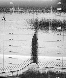
Fig. 1. This image shows a large plume of methane-rich water, visible as a dark cloud, extending from the bottom hundreds of meters up into the water column. At the base of the thermocline (a water layer where temperature changes with depth), some of the gas bubbles are trapped forming a horizontal layer of methane-rich water in the upper water column. Click image for larger view and image credit.
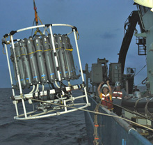
Fig. 2. Kazumi Shibata, a Woods Hole Oceanographic Institute technician, directs the winch operator during deployment of the CTD (a rosette instrument that measures conductivity, temperature, and depth). The rosette contains water sampling bottles (the long gray bottles) and a physical/chemical sensor array, which is mounted horizontally along the bottom of the frame). Click image for larger view and image credit.
Sniffing for Methane
May 23, 2006
Mandy Joye
University of Georgia
27° 38.85 N
088° 21.72 W
The Expedition to the Deep Slope focuses on the study of seep-associated fauna and the sediments where the fauna live, but we are also interested in the following questions: What happens to the seep-derived material – both oil and gas – that escapes the benthos (bottom) and reaches the overlying water column? Do water-column microorganisms convert methane to biomass and reduce the flux of this important greenhouse gas to the atmosphere? Methane consuming microorganisms can be thought of as an effective biological filter (a "biofilter") that prevents methane from reaching the atmosphere. The efficiency of the methane biofilter around seeps, and possibly in the water column, is not presently known.
To study methane dynamics in the water column over seeps, we use a variety of techniques. In shallow water (less than 1,000 m), we can use chirp sonar to visualize gas plumes in the water column (fig 1). The plumes are visible using acoustic methods because sound travels differently through water containing gas bubbles.
To describe the structure of the water column and decide where we should collect water samples for analysis, we conduct a hydrocast. A hydrocast entails using a system of remotely controlled water-sampling bottles, called Niskin bottles, and a suite of chemical sensors. The bottles and sensors are mounted on a rosette that is lowered through the water column by winch and a conducting cable (fig 2). As the chemical sensors descend through the water column, they report back to a computer on board the ship, allowing us to visualize the physical and chemical conditions of the water at each depth and select depths for water sampling. This image (fig 3) shows a typical depth-profile of salinity and temperature, collected at the Atwater Valley 340 study site at a depth of 2,200 m. As the rosette is slowly brought back to the surface, water samples are collected by remotely triggering the Niskin bottles to close.
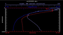
Fig. 3. Profiles of temperature (shown as dark blue), salinity (red) and dissolved oxygen (light blue) collected from the Atwater Valley study site. Temperature decreases rapidly with depth as does salinity (though not as much). Dissolved oxygen concentrations show a strong mid-water minimum but increase towards the bottom of the profile. Click image for larger view and image credit.
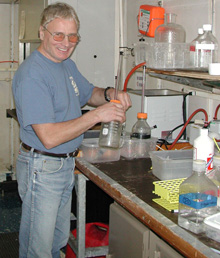
Fig. 4. Explorer Vladimir Samarkin prepares to extract methane from a water-column sample. Click image for larger view and image credit.
With the samples on board, we can use sensitive laboratory techniques to analyze methane concentrations and the rate at which the microorganisms are using the methane in the water (fig 4). With these data, we can determine the efficiency of the methane biofilter. We also measure a suite of additional chemical parameters, like oxygen and nutrient concentrations, with the hope of learning more about what regulates methane oxidation in the water above cold seeps.
So far on this cruise, we have quantified supersaturated concentrations of methane in the bottom waters and, surprisingly, throughout the water column. A very unusual, thick layer of low oxygen water has also been noted at mid-water depths (about 300 to 1,000 m) at all of the sites we’ve examined so far. At this point, we still have many more questions than answers about this strange mid-water anomaly. Hopefully, we’ll have more answers to share before the cruise ends!
Sign up for the Ocean Explorer E-mail Update List.