


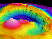
Brothers Volcano as looking into the caldera from the south. The smooth cone (left foreground) is the site of recent volcanic eruptions and has ongoing hydrothermal venting from its summit crater. The smaller cone (to the right) is probably older, but it still has an intense hydrothermal system at its summit. The rougher, eroded topography of the caldera wall are older pre-caldera lavas and other volcanic rocks that have undergone submarine slope failure, at least partly due to undermining by hydrothermal “weathering.” Click image for larger view and image credit.
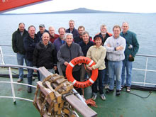
New Zealand American Submarine Ring of Fire 2007 science party explorers (left to right):
Row 1: Sharon Walker, Susan Merle
Row 2: Dana Yoerger, Alan Duester, Edward T. Baker, Kevin Faure
Row 3: Michael Hacking, Bob Embley, Matt Leybourne, Bryan W. Davy, Joseph Resing
Row 4: Andrew Billings, Ron Greene, Cornel E.J. de Ronde
Click image for larger view and image credit.
The Final Map
August 16, 2007
Bob Embley
Chief Scientist
Geophysicist
NOAA Vents Program, PMEL – Newport, Oregon
Read the NZASRoF'07 Final Cruise Report (4.7 Mb, PDF)
![]() Take a virtual tour of ABEs high-resolution bathymetry, collected at Brothers submarine volcano! (Quicktime, 1 Mb.)
Take a virtual tour of ABEs high-resolution bathymetry, collected at Brothers submarine volcano! (Quicktime, 1 Mb.)
The New Zealand American Ring of Fire 2007 expedition has been an outstanding success for all partners. Last night, out automous benthic explorer (ABE) team leader, Dana Yoerger, showed us the final map of the caldera (depressions) of Brothers Volcano. We just sat there, staring at it in silence for a few seconds, knowing that we were probably the first to see a submarine volcanic caldera as it really "is." Flying into the volcano, you pass over the two cones: the large smooth-sided cone with its small crater that is the site of most of the recent volcanic activity, and the smaller cone (to the right) that is partially eroded but still has intense hydrothermal activity at its summit. As you approach the wall of the caldera, the rugged topography (surface features) created by the degradation of the rocks from older eruptions is apparent. The comprehensive, co-located topographic, magnetic, and water-column mapping of Brothers Volcano is a new tool for exploring this “type” submarine volcano, and we are seeing it in greater detail than ever before.
The ABE Team of Dana Yoerger, Al Duester, and Andy Billings performed magnificently. Our mission's success is a testament not only to their professional expertise, but also to their enthusiasm and dedication to ocean exploration. Our German partners (GEOMAR) are also very pleased with the successful testing of their new Quest 6000 remotely operated vehicle. Chief Scientist Colin Devey and ROV Team Leader Thomas Kuhn have done a great job organizing and keeping the sea-going program on track.
Finally, we thank the personnel of the research vessel Sonne for their outstanding professionalism in making this expedition a success.