


Photo & Video Log
This page contains photos and videos taken during the
New Zealand American Submarine Ring of Fire 2007: Exploration of the Kermadec Arc expedition
that takes place July 28 – August 16, 2007. Click on any image to view
a larger version and for additional information. If a movie camera icon
![]() is
present, a QuickTime video can be viewed by clicking on the image. Other
video formats are available on the linked pages. If a Podcast icon
is
present, a QuickTime video can be viewed by clicking on the image. Other
video formats are available on the linked pages. If a Podcast icon ![]() is
present, a video or audio file is available for download or you can subscribe to the RSS Podcast Feed.
is
present, a video or audio file is available for download or you can subscribe to the RSS Podcast Feed. ![]()
If a slideshow icon ![]() is
present, a visual log of exploration images can be viewed. You can scroll
through them one by one, or select the play button for an automatic slideshow.
is
present, a visual log of exploration images can be viewed. You can scroll
through them one by one, or select the play button for an automatic slideshow.
(HR) = "High Resolution" images available.
 Video & Slideshows
![]() August 16
August 16
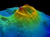
Take a virtual tour of ABE’s high resolution bathymetry from the Brothers submarine volcano! (Quicktime, 1 Mb.)
![]() August 10
August 10
View a slideshow of ABE high resolution bathymetry overlaid on EM300 bathymetry at Brothers Volcano. (HR)
![]()
![]() Mission Plan
Mission Plan
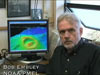
Learn what Bob Embley hopes to discover on this expedition to the Kermadec Arc. (Quicktime, 1.8 Mb.)
Images
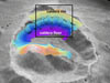
August 16
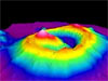
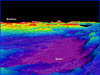
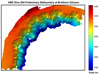
ABE high resolution bathymetry of the Brothers Volcano, looking into the caldera from the south. (HR)
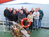
August 16
NZASRoF'07 science party explorers. (HR)
August 14
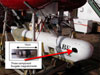
View of the front of the ROV, which consists of propellers, hydraulic pumps, and lots of cameras, lights and electronics, as well as two arms. (HR)
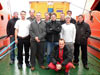
August 14
The ROV team, consisting of eight scientists and engineers from all over the world. (HR)

August 14
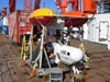
View from inside the IFM-GEOMAR Quest 7 ROV control van. (HR)
August 10
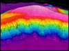
ABE high resolution bathymetry overlaid on EM300 bathymetry at Brothers Volcano. (HR)
August 9
View of Basin I, one of the deepest basins in the Havre Trough with a depth of more than 3,400 meters. (HR)
August 9
Map showing the location of several of the small rift basins in the Havre Trough that have been sampled by our CTDO system during the cruise. (HR)
August 5
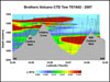
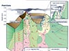
Cross-section of Brothers Volcano, from northwest to southeast. (HR)
August 5
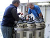
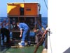
Scientist examine the CTD package before its deployment at Brothers Volcano. (HR)
August 3
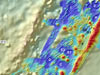
Map of the northwest slopes of Brothers Volcano created from ABE bathymetry. (HR)
August 3
Three-dimensional view of the amphitheater-shaped slump scars on the northwestern wall of Brothers Volcano. (HR)
August 1
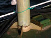
ABE AUV in its docking cradle. The red arrow indicates the location of the fluxgate magnetometer. (HR)
August 1
Surface tow total-field proton magnetometer. (HR)
July 31
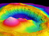
Three-dimensional image of Brothers Volcano looking to the northwest. (HR)
July 31
This is a illustration of a section through Brothers Volcano showing the evolution of the hydrothermal systems there. (HR)
July 31
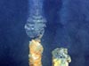
A good example of one of the many active hydrothermal chimneys that occurs at the northwest caldera site. (HR)
July 30
Making final checks on the ABE autonomous vehicle before its first dive at Brothers submarine volcano. (HR)
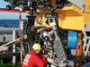
July 30
Engineers attending to the Kiel 6000 remotely operated vehicle under the massive A-frame on the stern of the R/V Sonne. (HR)
July 30
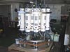
Conductivity-temperature-depth (CTD) package. The large white cylinders on the frame are used to collect water samples over geothermal systems. (HR)