


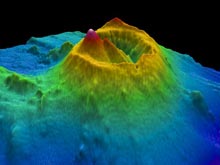
A three-dimensional image of Brothers Volcano as viewed looking to the northwest (NW). The cone at Brothers is prominent in the southern part of the caldera (crater) and rises about 350 meters (1,150 feet) above the caldera floor to a depth of about 1,100 m (3,600 ft) below sea surface. An extensive hydrothermal field occurs atop this cone and also on the summit of the smaller cone on its flanks. A bigger hydrothermal vent field again is perched on the NW caldera walls. Click image for larger view and image credit.
Here We Are Again: Over Brothers Volcano
July 31, 2007
Cornel E.J. de Ronde
Geologist
GNS Science
Lower Hutt, New Zealand
Here we are again over Brothers Volcano with the research vessel (R/V) Sonne. It feels like I have gone full circle with expeditions to Brothers, as it was aboard the Sonne in late 1998 that I first had anything to do with this particular volcano. It was then that we discovered that Brothers was host to some active hydrothermal venting on the sea floor. Using towed cameras and video, we imaged the tall chimneys perched on the steep walls of the northwest caldera site at Brothers. Several of the instruments we attached to the camera array confirmed that, indeed, hot metal-rich fluids were being expelled inside the caldera (crater) at Brothers. That was an exciting time, followed by three NZAPLUME cruises (1999, 2002, and 2004) that re-visited Brothers and mapped and sampled in detail the “black smoke,” or hydrothermal plumes, that emanated from the many active chimneys on the volcano.
In late 2004, we dove four times on the vent sites at Brothers with the Japanese manned submersible Shinkai 6500, followed in 2005 by five dives with the American submersible Pisces V. These dives provided us with a wealth of information about the location of the vent sites, samples of the metal-rich chimneys themselves and the hot water (and gases) that were being expelled by the chimneys, and the discovery of new species of vent-related animals. Combining the information gathered from the dive expeditions with that from the NZAPLUME and previous R/V Sonne cruises, enabled us to build a picture as to how the hydrothermal systems at Brothers may have formed, thus helping us to understand how these submarine volcanoes evolve.
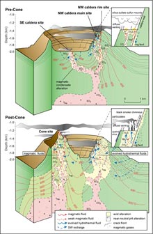
This illustration of a section through Brothers Volcano shows the evolution of the hydrothermal systems there. Initially, the NW caldera site was formed, followed by the emplacement of the volcanic cone in the southern part of the caldera, where a second hydrothermal field was formed. Originating from the magma below this field, gases eventually find their way to the sea floor where they are expelled. Click image for larger view
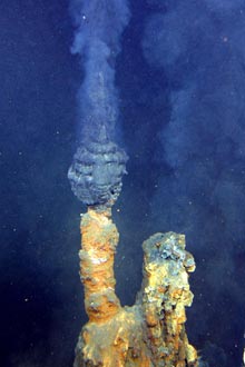
A good example of one of the many active hydrothermal chimneys (commonly known as “black smokers”) that occurs at the NW caldera site. During the NZAPLUME cruises, the detection of smoke emanating from chimneys such as this enabled us to locate numerous hydrothermal vent fields along the Kermadec Arc. Click image for larger view
But for all the work we have done at Brothers Volcano — and we have done more at this volcano than any other along the Kermadec Arc — there is so much still that we don’t know. For example, while we have bathymetric data that allows us to picture the volcano at a large scale, the resolution of that data is about 25 meters (about 80 feet), which means we don’t know any of the details of the sea floor at Brothers except what we saw outside the portholes of the submersibles. So it is a bit like going from looking down at Brothers Volcano from a small plane 2 kilometers (a little more than 1 mile) up in the air, to then looking outside your car window at the rocks nearby. That is why this time around we are deploying the autonomous underwater vehicle known as ABE (autonomous benthic explorer), from the Woods Hole Oceanographic Institution.
ABE can literally be programmed to "fly" over the sea floor, usually about 50 meters (m) above bottom — without being tethered to the ship — where it can map out features with a resolution of about 1 m (3.28 ft)! That means ABE will "see" large chimneys (some of which are 7 m tall) and can map out a small car. Effectively, this greatly enhances the detail of our maps of the caldera at Brothers. It's a bit like looking at something through the thick glass of a Coke bottle, then removing the bottle and seeing things clearly for the first time.
ABE will also be "bristling" with a number of other sensors, such as a magnetometer, which will tell us something about the areas within the caldera where hot water reached the sea floor from below, and where older (now dead) chimneys might occur. Other sensors will measure and locate the numerous hydrothermal plumes inside the caldera. In the end, we will have a wonderful 3-D virtual model of the volcano that will show exactly where all the chimneys and hot springs are, all "draped" over a very detailed map. Finally, if we are lucky, will we use the Kiel 6000 remotely operated vehicle to dive on any new or different sites at Brothers that ABE might discover to video and sample chimneys and hot water. Exciting times ahead!
Sign up for the Ocean Explorer E-mail Update List.