


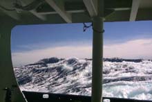
Big waves on the high seas. Click image for larger view.
SeaBeam Mapping on the High Seas
September 13, 2001
Diana Payne
The Maritime Aquarium at Norwalk/
Connecticut Sea Grant
Karl Stanford, Teacher
Lincoln Academy, Newcastle, Maine
"Attention all hands, attention all hands. We will be making a turn. Prepare for rolling motion."
--Any crew member at the helm of the R/V Atlantis during the last three days
Once again, the Alvin dive was cancelled. The science party has sat by this week and watched dive after dive fade. Still, few sat idle. Digital video and still pictures were edited and enhanced electronically. Some try to catch a nap, making up sleep lost due to the constant tossing of the R/V Atlantis in the early morning hours. Each task was complicated by the nearly constant rolling and pitching of the ship. The ship's intercom toned, "Attention all hands, attention all hands. We will be making a turn. Prepare for rolling motion." The warning was welcome, although some of us asked, "So, this will be a change?" Through most of the day, we plowed through white-capped swells as the ship's SeaBeam® multibeam sonar system pinged the depths below. Although Alvin was unable to dive today, the other high-tech tools aboard the Atlantis didn't go unused. The topography of the marine seamounts was analyzed using the latest in acoustic technology. A bathymetric chart of the area shows isobaths (similar to contour lines on a topographic map) ringing each of the seamounts. Two of the seamounts, Bear and Physalia, were planned dive locations on this leg of Deep East, but both dives were cancelled.
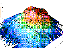
SeaBeam 3-D visualization of Bear Seamount. Click image for larger view.
The problem with current bathymetric charts is that they give only a crude shape of the undersea canyons and plateaus, particularly this far offshore. The SeaBeam system worked through the day, raining sound waves down onto the sea floor like the spray pattern on an aerosol paint can. The frequent course changes were necessary for SeaBeam to do its job properly. When an area is mapped using the SeaBeam system, the ship has to steam down a series of parallel lanes. Each lane "paints" another swath of data points into the computer. The decision regarding lane spacing depends on the depth of the water.
SeaBeam's task is not an easy one. For any map to be useful, it must be referenced to a datum -- an objective benchmark. Both topographic and bathymetric maps are customarily referenced to mean sea level (the midpoint between high and low tide). If the Atlantic was a flat pond or puddle, this reference point would be simple. As the Atlantis steams its lanes, however, it heaves up and down as much as 5 m. The ship rolls up to 14 degrees from port to starboard, and it pitches up to 10 degrees through the swells. Through all of this, the SeaBeam sends 141 sound beams into the water every 8 seconds as Atlantis travels at about 8-9 knots. The system uses the return time for each echo to calculate the distance from the ship's hull to each of the 141 points on the ocean floor.
If this sounds like a mathematical nightmare, it should! To add one more complication, the system must record and plot the location of the ship on the sea surface, too. This is accomplished using the GPS (global positioning system), a system of satellites that can locate any position on land, sea, or water to within a few meters.
The products of the SeaBeam system and the amount of data it collects are impressive. Just a few minutes of SeaBeam sampling provides more data than were used to produce the original NOAA depth charts for this entire area. The system "stitches together" the data collected from each lane of sampling and renders a color-keyed, three-dimensional map of the ocean floor. Information on the map is critical to the pilot and crew of the Alvin submersible as well as to the scientists aboard the R/V Atlantis. Dive locations are not selected randomly; they are based on the shape and slope of features on the ocean floor. Data collected by the SeaBeam system will also be made available to the public for research purposes.
Alvin sat quietly in its hangar today, but thanks to the SeaBeam system, science has millions of new data points -- important tools in the continuing exploration of Deep East.
(top)
Captain William Hugo Amaru
Interview with Captain William Hugo Amaru
Commercial Fisherman, Owner/Captain, F/V Joanne All
Ocean Explorer Team: What is your purpose on the Deep East Expedition?
Capt. Amaru: Dr. Peter Auster invited me to participate as a member of the Deep East team to act as an information conduit for the team about sea-floor issues from the perspective of a commercial fisherman. I was also hoping to become better informed about the techniques that a 21st-century scientific expedition of discovery would employ.
Ocean Explorer Team: What is your perspective as a commercial fisherman on this expedition?
Capt. Amaru: Well, you have to understand that within the commercial fishing industry, some fishermen have been challenged by scientists for the destruction of habitats. There is a question within the fishing community concerning the evidence of said destruction. Most fishers are aware of the concern over damaging ocean habitats, and we are not ignorant to the situation. Moreover, we want to improve our technology to lessen any actual impacts on sea-floor communities and their environment. Another important focus, at present, is to create a relationship that develops a bond between the science and fishing communities. Many fishermen think like scientists, and want to work with scientists on some common goals, such as long-term sustainability. The science community often overlooks the fact that the commercial-fishing public has a great deal of information to share. It could be more productive to pool that knowledge and work to improve our perceptions of each other. As an example, the Sea Grant Program in New England has successfully joined science and fishing for positive results that came from very different sources.
We believe that science can benefit from the fishing industry's collective knowledge of the marine environment with an emphasis on cooperative research. Together, we can investigate how various habitats are being affected by bottom fishing. Fishermen can also help collect specific information on animal species, and collaborate with stock assessments for both the science and fishing communities. We are already working to see this become a reality, but we need to do more.
Another issue is that we need to better define our terms. The term "clear-cutting," for example, is a harsh accusation for the fishing community to bear. We do not want to damage an entire ecosystem, as the term implies. Fishermen tend to go back to the same fishing areas year after year. If we were, in fact, doing the kind of damage that the term implies, we would have been ashore with no fish to catch long ago. Not all that we do in taking from the oceans harms the environment, and not all fishing is done the same way. The fishing industry is trying to change in ways that are positive, and we want to provide for the greatest benefit while lessening the impact on the environment. Distorted information provided out of context has a negative impact on fishing people and their families. Fishermen are proud and very independent people. We need to take a look at the techniques for catching certain types of fish and improve in that area, but we will do a better job if we find common ground and promote mutual respect for each other in doing so.
Ocean Exploration Team: What type of personal background do you have to be the captain of a commercial fishing boat?
Capt. Amaru: I was born in Rhode Island and have always been a coastal dweller. I graduated from the State University of New York at Albany with a bachelor of arts in musical performance. From there, I played with the Albany Symphony on clarinet. After moving back to Cape Cod, I worked on the side cod jigging, as I had done to get through college. As a child, I always loved to fish, and I did quite often. It got to a point where I needed to make a career choice. I purchased my first commercial boat, a 30-ft Maine- built lobster boat, in 1974, and began a new full-time career. To this day, I still have a strong feeling for my music and enjoy it every day.
Ocean Exploration Team: How does your commercial fishing vessel differ from the R/V Atlantis?
Capt. Amaru: No comparison. The vessels are as different as night and day. The only things they have in common are a diesel engine and a crew. Each ship has its own marine function. The R/V Atlantis is the most modern and comfortable research vessel on the East Coast. It is designed for data collecting around the world and is funded by research or educational organizations and the U.S. Government. My commercial fishing vessel is designed to catch fish and to provide income to my crew and myself. It is a small, basic boat of 50 ft that I lavish tons of attention and love on, and it loves us back.
Ocean Exploration Team: How does this expedition relate to commercial fishing?
Capt. Amaru: This is a most relevant question. I believe that good science developed by a broad-based science approach produces the best tools for the development of sustainable and renewable fisheries. Combining the scientific and practical backgrounds of divergent groups, as Deep East does, sets an example for how best to develop and harvest renewable marine resources.
Interview by Caren A.D. Menard of the Ocean Explorer Team.
(top)
Dr. Ivar Babb
Interview with Ivar G. Babb
Director, National Undersea Research Center for the North Atlantic and the Great Lakes
Ocean Explorer Team: What type of technology is used to evaluate a study site?
Dr. Babb: We use several technologies to assess a site prior to diving. Initially, we brought NOAA bathymetric (depth) data into a geographic information system (GIS). These data, together with historical dive data and towed camera systems, were used to select the initial dive sites. We then selected the boundaries of an area to be surveyed using a multibeam sonar system. This system provides a landscape view of the ocean floor using, as the name implies, multiple sonar beams to cover a wide swath of the ocean floor. We can then use the shipboard computers to generate a 3-D map that provides a good view of the topography of the sea floor. All of the research being conducted on this leg will make good use of this capability. For example, knowing the relationship of coral communities to the landscape features gives us clues to their ecological role, recruitment, and reproduction. The genetic work being done on the corals will also rely upon these maps to better understand the spatial relationships of populations that may or may not be from the same gene pool. The depth is also a major determinant of fish distributions.
Ocean Explorer Team: What are the outreach applications for this type of technology (GIS and multibeam)?
Dr. Babb: These technologies allow us to visualize the sea floor with a satellite view. The map provides the baseline upon which we can add layers, including population data and genetic information. Most people view the ocean as a vast, flat blue plane. These maps show the extension of the land and its complexities beneath that featureless plane, and gives a more complete three-dimensional picture of the oceans. These maps, combined with outstanding video and photographic imagery, provides the public with a new perspective on the ocean's beauty and complexity. It is hoped that this will raise public awareness of the deep sea and help generate greater stewardship and conservation of the oceans. These maps also have an immense commercial application in terms of precisely mapping sea-floor resources.
Ocean Explorer Team: How can the imagery and maps be utilized?
Dr. Babb: We hope to develop virtual tours of the sea floor combining all of the data layers and imagery. These would be implemented on interactive Web sites and distributed on CD-ROMs or DVDs. Researchers will directly use the maps in reports, presentations, and publications. They also provide scientists with a tool to measure changes over time and space.
Ocean Explorer Team: What type of educational degree do you have for the job that you do?
Dr. Babb: I hold a master of science in marine botany from the University of Maine, specializing in the study of seaweeds. I also have a master of marine affairs from the University of Rhode Island.
Ocean Exploration Team: Personally, what do you hope to gain from your experience with the Deep East Expedition?
Dr. Babb: Many facets of this expedition will remain with me for a long time. Clearly, I will remember and apply the new discoveries we are making of the deep-sea canyons and seamounts. If Hurricane Erin permits me the opportunity to dive in the Alvin, I will learn more about the submersible's capabilities and limitations. I have dived in several other submersibles and have a good understanding of what they can do, but this will give me a better idea of what Alvin can do. Secondly, I am gaining a great deal of personal satisfaction dealing with the scientists, technicians, educators, teachers, writers, and artists on this cruise. The group is truly diverse, with each person having a fascinating background and personal history. There are also an amazing comaraderie and chemistry on board as we deal with the horrific news from New York City, Washington, DC, and Pennsylvania, both individually and collectively. Finally, we are truly exploring new areas of the ocean. The thrill of discovery as one dives, using scuba, remotely operated vehicles, or submersibles, never grows old. Speaking from experience is always the loudest voice.
Interview by Caren A.D. Menard of the Ocean Explorer Team.
Sign up for the Ocean Explorer E-mail Update List.