


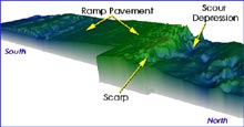
Figure 1. This single-beam bathymetric map of the Charleston Bump (courtesy NOAA Ship Whiting) shows its major features. The ramp is formed by the tilted pavement of Maganese-Phosphorite rock. Click image for larger view.
A Bump in the Stream: The Convergence of Geology and Physics
Rich Styles
Dept. of Geological Sciences and Marine Science Program
University of South Carolina
Leslie Sautter
Project Oceanica
Dept. of Geology, College of Charleston
The Charleston Bump is a large geologic feature located just beyond the edge of the continental shelf of the southeast U.S. coast, approximately 150 km southeast of Charleston, South Carolina. The actual “Bump” consists of a flat, rocky ramp that gradually rises from a depth of 700 m to shallower than 400 m (Fig. 1). This ramp trends roughly from south to north. At the end of the ramp, the sea floor drops precipitously for more than 100 m, forming a nearly vertical scarp, or cliff-like wall. Overhanging rocky ledges occur along the face of this scarp and provide excellent habitat for many species of fish. Just north of the scarp is a deep basin-like area (the “scour depression”) that shows signs of significant erosion by strong bottom currents resulting from the way in which the Charleston Bump deflects the Gulf Stream.
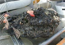
Figure 2. Example of a Charleston Bump Mn-Phosphorite rock collected from the scour depression in 2001. This specimen is 70 cm in length and weighs nearly 100 lbs. Many invertebrates are attached to the rock, illustrating how these creatures anchor themselves in the swift currents of the Gulf Stream. Click image for larger view.
Grown in Place
The Bump is an unusual sea-floor feature, as the rock that forms the pavement-like surface is Manganese-Phosphorite (or Mn-Phosphorite for short). This type of rock is not formed from the cooling of magma, nor is it cemented particles of sand. Instead, Mn-Phosphorite is formed chemically, from the precipitation of mineral matter directly from seawater. Occasionally, seawater becomes overenriched, or supersaturated, with phosphate ions (dissolved particles with a chemical-electrical charge), either from increased upwelling of nutrients, or from erosion of phosphate-rich sediments lying on the continental shelf. If there are too many phosphate ions for the seawater to “hold,” those ions bond with others, forming a solid.
In the case of the Charleston Bump, the Mn-Phosphorite formed as small nodules and, eventually coated over the existing seafloor sediments, “blanketing” the seafloor. This rock pavement is very solid and 1 m thick in some places. This type of rock is classified as a chemically precipitated "authigenic" (grown in place) sedimentary rock. It is extremely dense and resistant to erosion (Fig. 2).
Geologists from the U.S. Geological Survey (Drs. Pete Popenoe and Frank Manheim), who have studied the Bump, believe that the Mn-Phosphorite was formed approximately 10 to 15 million years ago, in the mid-Miocene period. Since the Miocene, fracturing and faulting of the sea floor in the region has caused the pavement to tilt, forming the cliff-like scarp.
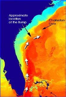
Figure 3. The path of the Gulf Stream (shown with white arrows) is easily identified on this sea surface temperature satellite image, where warm waters appear as oranges and reds, and cooler waters as yellows, greens and blues. The deflection of the Gulf Stream by the Charleston Bump results in the development of a counterclockwise rotating eddy, called the Charleston Gyre. Click image for larger view.
A Bump in the Stream
The Charleston Bump is a prominent feature that lies directly in the path of the Gulf Stream (Fig. 3) – one of the most significant physical features of the South Atlantic Bight (the region that stretches from Cape Canaveral, Florida to Cape Hatteras, North Carolina). The Gulf Stream is a warm jet-like current that travels northward along the continental margin at speeds of 1.5 to 2 meters per second. Its width ranges between 100 and 150 km and its powerful flow extends all the way to the seafloor.
The Charleston Bump exerts a profound influence on the Gulf Stream’s path. As the Gulf Stream passes over the Bump, it is deflected seaward, generating a string of meanders similar to a lazy river passing through hilly terrain. On the Gulf Stream’s western edge, these meanders produce swirling centers of counterclockwise flow, known as cyclonic eddies. As these eddies spin, the sea surface tends to "bulge up" in their center, causing deeper, colder water to move upwards. This slow lifting of bottom waters is known as upwelling. The upwelling pumps nutrient-rich bottom waters toward the surface, resulting in high levels of ocean productivity. This is well demonstrated in the seasonal variability in primary productivity, as inferred from satellite imagery. Chlorophyll estimates derived from Coastal Zone Color Scanner (CZCS) images are highest in the vicinity of the Charleston Gyre, which is an eddy located just downstream (i.e., north) of the Charleston Bump (Fig. 4, also seen on Fig. 3).

Figure 4.Sea-viewing Wide Field-of-view Sensor (SeaWiFS) image of the Charleston Gyre and regional coastline. The gyre is generated by the interaction of the Gulf Stream with the Charleston Bump, which is located just southwest of the gyre. Click image for larger view.
The Gulf Stream transports a tremendous volume of water northward from the tropics. For example, the volume transported near the Florida coast is estimated at about 30 million cubic meters per second. In other words, if you were in the middle of the Gulf Stream, enough water to fill about 172,000 in-ground swimming pools would pass by you each second! Because of its magnitude, the Gulf Stream can be viewed as a large wall of moving fluid that continually carries warm tropical waters northward, toward temperate and subpolar waters. Therefore, the Gulf Stream is a major conduit for heat exchange and is a critical component of the global heat budget and associated global climate change.
The degree to which the Charleston Bump affects the Gulf Stream’s path and velocity is not well understood. As we continue to explore the Charleston Bump, we hope to learn more about the geological and physical interactions occurring in the region so that we can continuously improve our ability to characterize and assess this valuable marine ecosystem.