


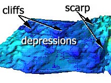
A 3-D visualization map of the Charleston Bump. This image was produced by the NOAA Ship Whiting using single-beam survey techniques. Click image for larger view.
Neptune’s Staircase: Cliffs and Terraces of the Deep
August 13, 2003
Leslie Sautter
Dept of Geology
College of Charleston
Although modern sea-floor mapping techniques have recently provided excellent 3-D visualization of the major features of the Charleston Bump, first-hand visual interpretation of the sea floor allows us to understand the rock formations and begin to piece together a geologic perspective. We are learning of the association between bottom-dwelling (i.e., benthic) organisms and the rocky sea-floor habitat, or substrate, on which they live. During our 10 dives on the Bump we have been able to collect many rock samples. Studying these rocks, along with interpreting videos taken by the submersible, has been critical in characterizing the foundation of the varied benthic environments.
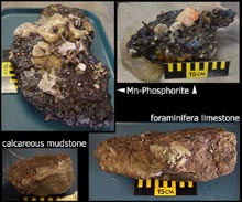
Various rocks collected during the Charleston Bump expedition. Click image for larger view.
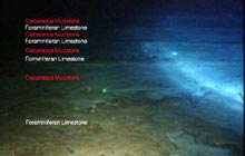
We have found three distinct rock types (see figure at left) that occur in alternating layers, or strata, all of which are classified as sedimentary rocks. Two of these are limestones (“carbonates”) and were originally formed as extensive flat blankets of sea-floor sediments that have been cemented and compacted over time. These rocks are composed of calcium carbonate (CaCO3). One is made of extremely fine particles that can only be seen with a high-magnification microscope. It is probably made of microscopic (<0.01 mm) marine plant remains of organisms called coccolithophores, although we cannot determine this at sea. The other carbonate rocks found here are made primarily of the tiny (<0.5 mm) shells of single-celled organisms called foraminifera. We refer to these rocks as calcareous mudstone and foraminifera limestone, respectively.
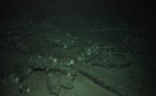
Large, table-sized slabs of rock comprise the substrate in some areas. Click image for larger view.
The third type of sedimentary rock is called manganese-phosphorite and is chemically precipitated from the seawater (see "A Bump in the Stream: The Convergence of Geology and Physics") . The Mn-phosphorite rock samples we have recovered are mostly comprised of small nodules ranging in size from 1 to 5 cm in diameter that have been cemented together with additional Mn-phosphorite to form a solid, very dense rock that is highly resistant to erosion.
Long after their formation millions of years ago, these strata of flat-lying rock were fractured, broken, and shifted by tectonic movements of the Earth’s crust. As a result, the sea floor in this region varies significantly from site to site. In some places, the substrate looks like a field of rock rubble, though in many areas the rocks are large, table-sized slabs. The different rock types have varying resistances to the erosive forces of the Gulf Stream’s bottom currents, where the phosphorite is most resistant and the mudstone is easily eroded particle by particle. The result is that erosion of the mudstone layers that lie under either of the other rock types creates overhanging ledges that are excellent habitat for benthic organisms and demersal (bottom-living) fish. Earlier this week, we found a school of 10 red bream (about .75 m long) and a single large (>1m) wreckfish nestled peacefully under a large phosphorite rock slab that provided a particularly cave-like habitat.
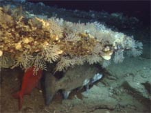
A red bream (Alphonsin) and a wreckfish nestle peacefully under a large rock ledge. Click image for larger view.
Perhaps the most interesting geology we encountered occurs north of the main Bump scarp in one of the deep depressions. On one dive, we discovered a region that descended 200 ft (from roughly 1,650 to 1,850 ft depth) over a distance of half a mile. In some places, the rocks formed nearly vertical cliffs, with alternating layers of the two carbonate rocks. Between these steep areas lie narrow terraces, creating a stairway to depths well below 1,800 ft. Overhanging ledges occur at some intervals, and corals, anemones, and sponges take full advantage of the protected underside of these overhangs. Richard Styles and Dara Hooker have named this rock terrace and cliff formation Neptune’s Staircase. The invertebrate organisms that inhabit these strata have preferentially selected the coarser foraminifera limestone as their substrate. Few, if any, organisms were observed attached to the mudstone, perhaps because of its low resistance to erosion, making it a tenuous substrate upon which to attach.
Neptune's Staircase: vertical cliffs with alternating layers of carbonate rock. Click image for larger view.
Throughout the staircase, phosphorite can be found intermittently as nodules or small individual rocks, but mysteriously, we never encountered a phosphorite rock layer. Where is the source of these small rocks? Did they erode and tumble down the slope from above? Why isn’t there a continuous or slabbed Mn-phosphorite rock layer as we’ve found elsewhere at the Bump? The answers to these questions remain elusive.
On our final dive, we returned to Neptune's Staircase to reexamine the strata and search for Mn-phosphorite layers. We encountered several large wreckfish, conger eels and some spectacular rock overhangs, but found no rock layers other than the two types of carbonate. At 1,817 ft, near the base of the staircase, we collected a single rock that contained two distinct layers of Mn-phosphorite, with foraminifera limestone sandwiched between, reminiscent of an Oreo cookie. This one rock trio tells us that somewhere nearby, layers of the phosphorite must be interbedded with the limestone. But where? Further exploration of the area is needed to piece together this layered rock puzzle.
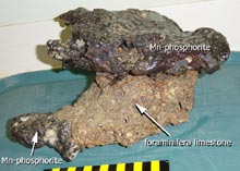
The single manganese-phosphorite rock collected at a depth of 1,827 ft. Click image for larger view.
“Reading” the rock strata from top to bottom is akin to going back in time, and these rocks have recorded variations in Gulf Stream current velocities for perhaps millions of years. The fine-grained mudstones reflect very low velocities that once allowed very small sediments to settle to the sea floor, whereas the foraminifera limestones indicate a periodic occurrence of slightly higher current velocities. Both these rocks were formed when the Gulf Stream was weaker than it is today, as very little sedimentation of any kind is presently occurring in the region. The current’s energy is now high enough to transport and suspend particles, while preventing them from settling to the bottom. What caused these variations in the Gulf Stream’s energy? Studying the multiple layers of the rock record may provide us with more information on ancient sea-level changes and climate variations.
Not only do the strata hold clues to past climate and Gulf Stream fluctuations, but the various sea-floor substrate types control the sea-floor topography and appear to play a major role in the lives of the benthic organisms inhabiting these depths. Are the distribution and diversity of benthic communities truly determined by the rocky substrate? There is so much to learn about the geology of this intriguing and unique structural feature off the coast of the U.S. southeast coast. We have seen less than 1% of the Charleston Bump, and with each dive have found exciting new features and different organisms. Further exploration will help us to understand the range of habitats and their inhabitants, and may provide important information related to the history of the Gulf Stream and climate change.