


Operation Fetch: Mapping, Imagery, Water Quality
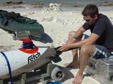
Daniel Jones preparing to launch the Fetch autonomous underwater vehicle (AUV). He is attaching Fetch’s “nose,” which contains the side scan sonar, some of the water quality sensors, and the color video camera. Click image for larger view and image credit.
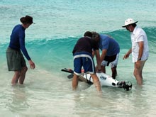
Bernard Laval, Daniel Jones, Mark Patterson, and Ken Collins launch the Fetch AUV off the beach at the Invisibles dive site. Click image for larger view and image credit.
January 21, 2008
Daniel Jones
Director, Project Serpent
National Oceanography Centre
Southampton, United Kingdom
![]() Fetch1 autonomous underwater vehicle (AUV) surveying parallel to the shoreline at the 18 Palms dive site on Bonaire. (Quicktime, 1.2 Mb.)
Fetch1 autonomous underwater vehicle (AUV) surveying parallel to the shoreline at the 18 Palms dive site on Bonaire. (Quicktime, 1.2 Mb.)
![]() Fetch1 AUV surveys within the Bonaire National Marine Park. (Quicktime, 1.9 Mb.)
Fetch1 AUV surveys within the Bonaire National Marine Park. (Quicktime, 1.9 Mb.)
![]() Fetch1 AUV ion a trial dive to ensure the vehicle is still sufficiently buoyant. (Quicktime, 774 Kb.)
Fetch1 AUV ion a trial dive to ensure the vehicle is still sufficiently buoyant. (Quicktime, 774 Kb.)
Since its release from customs, the Fetch autonomous underwater vehicle (AUV) has had a busy time in Bonaire. On our first day of operations, we assembled the vehicle from parts in many cases. Fetch is less modular than the Gavia AUV so most of the vehicle was intact. Fortunately, it was not subject to its usual full dismantling inspection in customs; AUVs are not a typical shipment and are often heavily scrutinized.
After we re-assembled Fetch, we ran through the normal system checks — "talking" to the robot via an ethernet linkage and checking all the core control and sensor systems. Unfortunately, after the long journey, we had some trouble starting the computer that is the "brain" of Fetch. We eventually got it started and took the vehicle on a trial dive from the shore. We adjusted the buoyancy with small weights attached to the outside of Fetch to ensure that the vehicle could dive (but was still sufficiently buoyant to surface if there was a problem with the robot). With all this complete and some test dives completed, we felt ready for some longer missions the next day (January 12, 2008).
On January 13, we awoke excited about the following day’s missions and eagerly plugged into the robot to start system checks. But there was a problem. An unidentified error was preventing the Fetch computer from consistently starting. We started the day with an intact robot, but several hours later the room was covered in circuit boards and other electronic parts as we inspected all the potential sources of error. We eventually found the source of the problem: the lithium battery on the motherboard of the Fetch computer was low and causing all the errors. Fortunately (and surprisingly), the battery was in stock in dive shops and we could quickly replace it. We also took the opportunity, having taken the majority of the robot apart, to install the video camera system, adding a visual record to the data collected. After putting the robot back together, we started system checks and everything worked! By this time it was far too late to do water tests, which we would have to leave until the next day.
The Fetch (in the foreground) and Gavia (in back) AUVs simultaneously conducting survey missions at the Invisibles dive site. Click image for larger view and image credit.
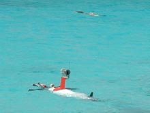
The next morning (January 14), we launched the robot from the beach for its first data-gathering mission. We ran a few tests and then sent Fetch on her way to dive at a constant depth of 10 meters and to go parallel to the shore collecting data on all of its sensors. We measured a number of water properties including temperature, salinity, and dissolved oxygen to give us an indicator of the physical environment of the reef. At the same time, we collected video images and side-scan sonar images of the seabed. The side-scan sonar produces a map of the seabed using sound to "see" in water, like we use light to "see" in air. The device produces a fan-shaped pulse of sound that extends to either side of Fetch. By using the time taken for the sound to return and the strength of the signal, the distance and hardness of the seabed can be mapped. The information we collect will provide a much higher resolution picture of the distribution of seabed types around Bonaire.
When all the data from the various projects is combined, we will be able to assess change in this environment since early mapping in the 1980s and to provide a very good baseline to assess future changes.
Sign up for the Ocean Explorer E-mail Update List.