


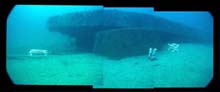
Mosaic compiled from digital video showing how the port armor belt is supported off the seabed by the Monitor's displaced gun turret. The white structures are cradles for holding anodes used to cathodically protect the wreck. Monitor Collection, NOAA. Click image for larger view.
Monitor Profile
Jeff Johnston
Monitor National Marine Sanctuary
NOAA
Description
For over a century, the wreck of the USS Monitor lay undiscovered. In August of 1973, scientists aboard Duke University's research vessel Eastward located the Monitor using sidescan sonar. The Monitor was placed on the National Register of Historic Places in October 1974 as a resource of national significance. In January 1975, the Monitor became the first National Marine Sanctuary.
The Monitor National Marine Sanctuary encompasses a vertical water column from the surface to the seabed extending horizontally one nautical mile in diameter 16.1 nautical miles south southeast of Hatteras Light, North Carolina. Maximum water depth in the Sanctuary has been recorded at 240 fsw.
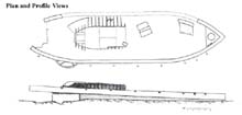
The hull of the Monitor lies in an inverted position with the port quarter armor belt resting on the displaced and inverted turret. The turret holds the port stern and much of the midships area above the bottom, producing an exaggerated list to starboard. The longitudinal axis of the hull lies on a bearing of 272 degrees with the bow to the west-northwest. Although most of the starboard armor belt is buried, extensive scouring keeps the port armor belt completely exposed and free of the bottom. Therefore, the port side of the hull is held above the bottom by the turret in the stern and, probably, the pilot house in the bow.
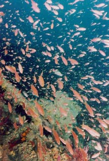
Red Barbier swimming around the wreck of the USS Monitor. At times, their number is so great, it is difficult to even see the wreck through them. Photo By Doug Kessling, Monitor Collection, NOAA. Click image for larger view.
Research and Education Objectives
The Islands Stream Expedition to the Monitor NMS is the 5th expedition to the Sancturary in 2001. The primary objectives are to document the changes to the site that have occurred since the engine was removed in July.
Secondary goals include an updated flora and fauna survey.
Go to Preserving the USS Monitor section of the Ocean Explorer Web site for previous expedition information.
Habitats
While the wreck of the USS Monitor is primarily viewed as a cultural resource, the site also serves as an artificial reef. The wreck is the only significant topographical feature within the sanctuary boundaries. The warm Gulf Stream waters that sweep through the sanctuary have helped to create a lively sub tropic ecological system.
Key Species
While an abundance of flora and fauna live on and immediately around the wreck, the predominant species of marine life encountered are Black Sea Bass (Centropristis striata), Greater Amberjack (Seriola dumerili), Red Barbier (Hemanthias vivanus), and Scad (Decapterus sp.).
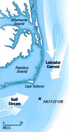
Map showing location of the Monitor National Marine Sanctuary and the prevailing currents. Click image for larger view.
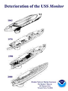
Illustrations showing the deterioration the Monitor has undergone since the vessel sank in 1862. The rate of deterioration to the ship has increased markedly since 1991. Monitor Collection, NOAA. Click image for larger view.
Archaeological site maps compile data from the year 2000 and previous Monitor Expeditions. Monitor Collection, NOAA. Click image for larger view.
Facts
The 5 Most Often Asked Questions
1. What is the Monitor National Marine Sanctuary?
In 1972, Congress passed the Marine Protection, Research and Sanctuaries Act in response to a growing awareness of the intrinsic environmental and cultural value of our coastal waters. The Act authorizes the Secretary of Commerce to designate discrete areas as national marine sanctuaries to promote comprehensive management of their special ecological, historical, recreational. and esthetic resources. On January 31, 1975, the resting place of the Civil War ironclad USS Monitor was designated this nation's first marine sanctuary. The Monitor National Marine Sanctuary, and all areas subsequently designated marine sanctuaries, are part of the National Marine Sanctuary System administered by the Sanctuaries and Reserves Division (SRD) of the National Oceanic and Atmospheric Administration (NOAA).
The Monitor National Marine Sanctuary is located approximately 16 miles south-southeast of the Cape Hatteras lighthouse. The Sanctuary is an area one mile in diameter that reaches from the surface of the ocean an to the sea bed. Water depth is 240 feet. Bottom conditions, including visibility, current, and temperature, are variable.
2. Why is the Monitor important in American history?
The Monitor was the first of a class of low-freeboard, turreted war ships developed during the Civil War by Swedish-American engineer and inventor John Ericsson. The Monitor was launched at Greenpoint, Long Island, on January 30, 1862. The ship was approximately 172 feet long with a beam of approximately 42 feet and was constructed almost entirely of iron. When fully loaded, it drew 9 feet of water. The Monitor was the first ship to have the engines and living spaces below the water line. The revolving turret housed two XI-inch Dahlgren guns. In early March, the ship was sent to Hampton Roads, Virginia, to face the Confederate ironclad Virginia , (ex-USS Merrimack). On the morning of March 9, the Monitor and Virginia fought the first battle between ironclad warships.
Despite the Virginia's much larger size and firepower, the Monitor clearly demonstrated the advantages of the revolving turret over traditional broadside guns. The battle marked the beginning of the end for traditional wooden ships of war and forever changed the way naval warfare was waged. The Monitor was lost in a storm off Cape Hatteras on December 31, 1862. Sixteen of her officers and crew were also lost.
3. How is the site protected?
NOAA protects the Monitor through comprehensive management and education programs, published regulations and cooperative agreements with state and federal agencies. The U.S. Coast Guard assists NOAA with the protection of the sanctuary through surveillance with boats, ships and aircraft.
4. Since the Monitor was a U.S. Navy ship, is the Navy involved in managing the site?
In September 1953, the Secretary of the Navy signed documents officially abandoning title to the Monitor. However, the Navy has maintained an interest in the Monitor and assists Sanctuary staff in historical and on-site research and recovery operations.
5. Can the wreck of the Monitor be raised?
The wreck of the USS Monitor has been studied by archaeologists, conservators, structural engineers, and corrosion experts. Most agree that the wreck cannot be recovered intact. Therefore, NOAA has ruled out complete recovery. However operations are under way to recover major components of the vessel. To date, the propeller, engine and associated material have already been recovered with plans in the works to recover the turret in 2002.
Sign up for the Ocean Explorer E-mail Update List.