


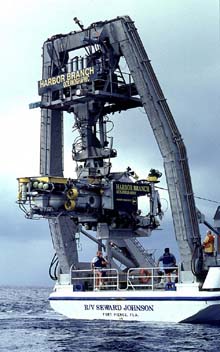
The South Atlantic Bight Mission used multi-person submersibles such as the Johnson SeaLink to conduct underwater observations as well as to collect specimens.
South Atlantic Bight Mission Summary
August 29 - October 1, 2001
Following a month-long hiatus, scientists resumed exploring the deep coral and hard- bottom communities beneath the Gulf Stream from Florida to North Carolina. These missions joined NOAA with the Harbor Branch Oceanographic Institution (HBOI) of Fort Pierce, FL as well as numerous state agencies and university scientists. A variety of technologies were used to study deep reef systems, including HBOI’s three and four person submersibles -- the Clelia and Johnson Sea Link -- at depths to 3000 feet.
Leg One: Oculina Banks, August 29 - September 5
The expedition to Oculina Banks assessed the condition of deep-water Oculina coral and associated reef fish and evaluated efforts to re-establish coral habitat and reef fish populations. Over an eight-day period, the mission conducted sixteen manned submersible dives and 13 remotely operated vehicle (ROV) dives to six areas within the 300 square mile elongated research reserve off the east coast of Florida between Fort Pierce and Cape Canaveral.
Scientists found that there has been significant habitat destruction and reduced fish abundance within the reserve over the last quarter century. Reefs visited 25 years ago showed loss of live coral. Healthy coral was found mostly on low-relief sites. Warsaw, scamp, and gag grouper; snapper; black sea bass; and speckled hind were all reduced in size and numbers compared to historical observations. There was evidence of bottom fishing activities in violation of rules for the marine protected area. These included trawl tracks and grooves on the bottom, broken and missing coral growth experiments, and recent breakage and mortality of corals.
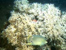
A healthy and intact Oculina coral head at Jeff's Reef at the southern end of Oculina Banks. The coral provides shelter for a variety of invertebrates and reef fish, including this blue angelfish. Click image for larger view.
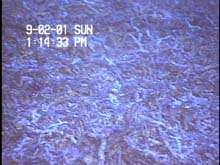
This Oculina coral rubble is in stark contrast to the healthy Oculina coral in the image to the left. Much of Oculina Banks is in this condition. Habitat destruction has reduced fish abundance in this area. Click image for larger view.
Scientists also noted several positive signs of ecosystem health. Two sites at the southern end of the reserve showed extensive coral cover on submarine pinnacles that rise 10 to 20 meters off the bottom. One new area of healthy and extensive live coral was found. Grouper populations showed signs of recovery at the two southern sites. However, it is premature to determine if the man-made reef balls and other artificial substrates deployed on the banks will support the renewed growth of Oculina coral which in turn will support abundant reef fish populations.
Leg Two: Savannah Scarp, September 6 - September 10
This two-day mission to the edge of the continental shelf off the coast of Georgia was to investigate a system of rock outcrops and ledges that range from one to several meters in height off the bottom. During this expedition, scientists working from two research vessels conducted four manned-submersible dives, collected numerous biological, sediment, and rock samples, and documented the area with approximately 25 hours of digital video footage.
Two scamps and numerous cubbyu (underneath the rock) were seen at this rocky outcrop. Rocks are attractive to fish because of the amount of life that attaches to them, and also because they are good hiding places. Click image for larger view.
Explorers discovered that there was little rocky hard bottom and ledge habitat in the area, but that the fish and invertebrate species present were strongly associated with any available rocky habitat. Despite the low relief of the area, the abundance of important reef fish such as red snapper, gag grouper, scamp grouper, and greater amberjack was higher than expected. Small, isolated rocks attracted bigeyes, juvenile snowy groupers, and butterfly fish. Larger isolated rocky outcrops were inviting to cubbyu and tropical species such as butterfly fishes, damsel fishes, and wrasses. On the periphery of large patches of large rocks were schools of vermilion snapper, red porgy and greater amberjack. Scientists had not expected to find high numbers of commercially important species in this low relief habitat.
Scientists also observed that the limestone outcrops, likely exposed by the force of currents at the edge of the Gulf Stream, were possibly formed from fine-grained carbonate sediments during a period of lower sea level. These outcrops act as islands of habitat for non-mobile invertebrates that attach themselves to this substrate. These biological communities were healthy and were much different in species composition than other invertebrate communities found closer to shore and outside the influence of the Gulf Stream.
Leg Three: USS Monitor, September 13-14 and October 3
The middle leg of the five-leg expedition was scheduled to visit the wreck site of the Civil War ironclad ship, the USS Monitor. The first objective was to place a transponder, also known as a "pinger," on the wreck to ground truth the coordinates on a scale image of the ship in a geographic information system. The second was to conduct a video survey of the wreck, concentrating on the area of the gun turret, which is the next major artifact scheduled for recovery in 2002. Two hurricanes, Erin and Gabrielle, scuttled the original mission.
However, following completion of the fifth leg of the expedition to the Charleston Bump, the scientists aboard R/V Seward Johnson II steamed from Charleston, South Carolina to the wreck site and conducted several manned submersible dives. They were able to collect several hours of video tape and document numerous species of fish that use the wreck as habitat.
Marine historians and archaeologists will be assessing the georectified video and still images over the next several months as they prepare for additional restoration and recovery work. This mission concluded several very busy and successful months of work at the Monitor, which included the recovery of the vessel's steam engine.
Leg Four: North Carolina Shelf, September 19 - September 26
This mission visited three distinct areas of the North Carolina continental shelf–The Point northeast of Cape Hatteras, where three currents converge to create a “hot spot” of productivity; Lophelia Banks, an extensive system of deep-water corals southwest of Cape Hatteras; and Cape Fear Terrace, an extensive area of hard-bottom communities. Over the mission’s six and one-half days, researchers conducted 10 dives in a manned submersible, collected over 35 hours of digital video, 60 hours of audio files, 200 still images, and numerous sediment and biological samples. In addition, 64 trawls, produced thousands of individual specimens of fishes and invertebrates. This information will be analyzed to enhance understanding of these sites.
During the expedition, scientists completed an initial characterization of the habitat, species, and ecology of The Point. Here scientists encountered numerous Atlantic hagfish in the soft mud and thousands of lanternfish just off the bottom. Other common species found at The Point were flounders, eelpouts, and rattails.
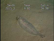
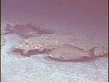
This witch flounder, one of the species found along the muddy banks of The Point, feeds on small shrimp, marine worms, and mollusks. Its grayish-white body allows it to blend into the soft sediments at the bottom. Click image for larger view.
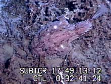
In contrast to The Point, Lophelia Banks is characterized by hard coral reefs. This anglerfish's flat shape and coloration make it difficult to distinguish from the surrounding coral as it rests on the sea floor. Click image for larger view.
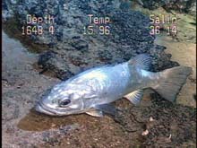
The Charleston Bump holds the only known North American population of wreckfish, a species that is also commercially fished in the eastern Atlantic, the Mediterranean, Brazil, and the western South Pacific. Click image for larger view.
Leg 5: Charleston Bump, September 27 - September 29
The South Atlantic Bight Mission concluded at the end of September with three days of operations in the vicinity of the Charleston Bump, an elevated outcrop of erosion-resistant rock 1200 ft below the surface. Also known as a popular fishing grounds, the outcrop deflects the Gulf Stream current to the northeast. The primary goal of this leg was to continue ongoing efforts to characterize the habitat and species that use this highly dynamic area.
Scientists investigated areas of high relief – ledges, walls, and pinnacles – downstream and in the lee of the main escarpment. The data collected will be added to a growing body of information to help determine the effectiveness of existing management measures or the need for new or different ones.
In addition to the visual images and samples collected by the submersible, scientists collected samples of fishes and invertebrates from several historical sampling stations around the Bump. As with the mission to the
North Carolina Shelf, samples were collected at the surface and from within the water column to help scientists understand more about the vertical distribution of species in this unique and dynamic environment.
Sign up for the Ocean Explorer E-mail Update List.