


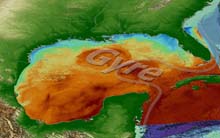
Map showing a gyre in the Gulf of Mexico. Click image for larger view.
Liquid Wind
Steve Gittings, Research Coordinator
National Marine Sanctuary System, NOAA
This summer, explorers and scientists from the United States, Mexico, and Belize will join forces to learn more about the international connections between marine ecosystems. Using submarines, underwater robotic vehicles, and satellite tracked buoys, they will investigate the reefs and other habitats in the three countries, and the water that connects them. It is called the Islands in the Stream Expedition. In the end, we will all better appreciate the inextricable links between the natural resources of neighboring countries and the fate of those who depend on them.
From the sky, the ocean looks like a giant parking lot. The familiar patterns of terra firma disappear beyond the shore. The sea has a way of internalizing all that it holds--its terrain and its creatures--while land displays form like a well-placed tattoo. Yet the ocean’s tranquility is a mask concealing tremendous strength. Every now and then, it erupts angrily, reminding us that, despite human perceptions, nature rules!
But it is more than pure power that the ocean hides from the air-breather. It conceals much of its beauty. Seldom seen are the mysterious and wondrous denizens of the deep. Inconspicuous are the delicate drifting plankton that constitute the living broth in the vast soup bowl that is the world’s ocean. Even the largest geological features on the planet--mountain ranges and canyons that make those on land seem irrelevant--are concealed within.
At first glance, the very forces that drive the system are invisible. These are the great currents. They writhe with the constant motion of snakes all over the globe, moving water and creatures about, controlling weather, and impacting our lives to an extent that few appreciate and none fully comprehend.
To understand currents locally, one must first think on a much grander scale. Huge, rotating gyres move massive amounts of surface water in circles around each of the large ocean basins, with stronger, faster moving currents along their western margins. Gyres north of the equator rotate clockwise; those in the southern hemisphere go counterclockwise. The gyres are flanked by countercurrents spinning in opposite directions, and smaller eddies that take the water and all that it holds in countless, often changing directions.
The Caribbean Sea, the Gulf of Mexico, and the U.S. East Coast are three areas connected by such currents. In this region is an enormous, north-flowing “river” of water. Most people are familiar with the portion of the river known as the Gulf Stream. It carries warm water from South Florida to North Carolina before heading northeastward toward Europe. In addition to preventing the tropics from overheating, along the way the Gulf Stream warms the temperate zone of the United States and deposits tropical animals and plants, even giving rise to coral reefs in Bermuda.
(top)
But where does it come from? Where does it start, and why?
In fact, it begins 93 million miles away. The sun generates heat that warms the lower latitudes of Earth much more than it does the higher latitudes. This heat causes the air to expand, generating winds that drag surface water along with them. The wind and water in the low latitudes of the Atlantic head westward, eventually running into the Americas.
Water enters the Caribbean Sea from the southeast and literally piles up inside the basin. It moves northwest in a poorly defined and highly variable stream called the Caribbean Current. It flows out through channels between islands in the north. It is forced into the Gulf of Mexico through a narrow and fairly shallow channel called the Yucatan Strait, which separates Mexico and Cuba. Here, it is called the Yucatan Current. Currents in this channel can be fierce. They are the reason that scuba divers in Cozumel, an island off the east coast of the Yucatan Peninsula, do “drift dives.” That is, instead of trying to stay in one spot, a nearly impossible task in ripping, 2-knot currents, divers descent in one spot, drift with the current, and pop up in another, hoping that their dive boat was able to keep up with them.
This is the area that gives birth to the well-defined current system that eventually becomes the Gulf Stream. The Gulf of Mexico is much like the Caribbean, except that it has only one entrance, the Yucatan Strait, and one exit, the Florida Strait. The Yucatan Current goes as far north as it can before experiencing too much resistance from the water already in the Gulf. Then it turns right, toward the exit. The turn gives this stretch of the stream its name--the Loop Current. It is almost always in the eastern Gulf, but can make the turn anywhere from just north of the Yucatan Strait itself to very near the continental shelf south of Mobile, Alabama.
The water in the Loop Current exits the Gulf through the Florida Strait between Florida and Cuba, where it is known as the Florida Current. It then passes between southeast Florida and the Bahamas and changes its name again, becoming the mighty Gulf Stream.
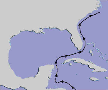
Map showing the formation of a eddy in the Gulf of Mexico. Click image for larger view.
Back in the Gulf of Mexico, the Loop Current itself seldom drifts into the western half of the basin, but its influence is extensive in this enormous cul-de-sac. Anywhere along the main path that the stream meanders a little too much to the right, eddies are pinched off, like a giant, unstable bubble that splits in two. Spinning clockwise at 2 or 3 mi an hour, some eddies are more than 100 mi in diameter. They carry their warm water westward over several months, strongly affecting currents in the western Gulf, but eventually lose steam and break apart when they hit the continental shelf off Texas or Mexico. Three or four such eddies may exist in the Gulf at any one time. Oil companies operating offshore keep a close eye on them, even naming them (I always thought “Nelson Eddy” was a good one). Sometimes they even have to stop operations as they pass, for fear that high currents might cause the failure of critical production or safety equipment.
In areas of the western Gulf without eddies, circulation is influenced mostly by wind and rivers. These currents are not nearly as strong as within or near the eddies, but they do affect life in the Gulf. In the southwest Gulf, circulation generally proceeds from the Yucatan Strait westward, then north along the western boundary of the basin. Meanwhile, most of the water exiting the Mississippi River, along with oceanic water already in the northwest Gulf, heads west along the Louisiana coast toward Texas. When this water collides with water arriving from Mexico, generally somewhere between Corpus Christi and Galveston, it shoots eastward along the outer continental shelf as the “Texas Current.”
Circulation in the eastern Gulf is also affected by the Loop Current. Countercurrents and semi-permanent eddies are spun up by the Loop Current, presenting some interesting possibilities for the movement of creatures up and down Florida’s western continental shelf. South of the Florida Keys, a counterclockwise eddy known as the Portales Gyre spins persistently on the north side of the Florida Current. This feature may allow larvae from the southern end of the Keys, or from the main stream itself, to become entrained and deposited on the shallow coral reefs farther north.
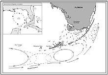
Map showing current patterns throughout the Florida Keys. Note how clockwise and counterclockwise gyres exist shoreward of the Florida Current. These tend to carry larvae and spores from place to place throughout the region. Knowing where parent stocks are located and understanding how currents transport their young allow resource managers to protect important areas before they become overharvested. Click image for larger view.
Similar phenomena exist all along the route of this great stream. Though the names may change along the way, the Yucatan Current, the Loop Current, the Florida Current, the Gulf Stream, and all of the countercurrents and eddies they spawn carry with them the larvae and spores of tropical species from Belize, Mexico and other Caribbean locales.
Ocean currents cast plant spores, animal larvae, and even adult creatures over huge expanses, sometimes between distant, isolated islands. Currents are the ocean’s version of the breezes that disperse the seeds of dandelions and maples, and the spores of mushrooms. They are the “liquid wind” that supplies and replenishes habitats of every kind in the ocean realm.
Because of the current system that begins along the Yucatan Peninsula, hard-substrate (also called hard-bottom) features lucky enough to be downstream from the Caribbean have become prime real estate for thousands of species of corals, sponges, fish and other tropical species--regional outposts displaying an unexpected tropical flair. One of the major suppliers that makes it all possible is the “Wal-Mart of coral reefs” in the Caribbean, the Meso-American Barrier Reef System (MBRS). This second longest barrier reef in the world (behind Australia’s Great Barrier Reef) lies off the coasts of Belize and Mexico. It may represent what scientists call a center of diversity for the region, which means that it contains nearly all of the reef species present in the region. In fact, other Caribbean reefs may have comparable diversity, but the sheer size of the MBRS makes it a likely candidate to carry the banner. In any case, there is no question about the importance of the output of the MBRS for points north. Its “manufacturing and distribution network” is ideal!
The Gulf of Mexico has a variety of hard-bottom areas around its periphery. In shallow waters, above 100 ft or so, are rocky outcrops along the Mexican coast of the southwestern Gulf. There are also a few shallow offshore banks in the northwest Gulf formed by upwardly migrating domes of 160-million-yr-old salt. Any such features that might be in the central part of the northern Gulf are covered by sediments discharged by the Mississippi, so they offer little in the way of hard substrate. East of the Mississippi is the West Florida Shelf, offering vast expanses of carbonate hard bottom for reef creatures.
At depths near 300 ft in the Gulf is a veritable “bathtub ring” of hard deposits. During the last ice age, the sea surface was at this level. Shorelines eroded, sand dunes formed and hardened along beaches, and reefs grew near shore. When sea level rose again with the melting of the glaciers, the ocean left these features below. Today, they serve as northern detachments of the Caribbean fauna and flora--an extension of the tropics.
Deeper still are other hard-bottom areas, but few have been explored. There are reefs formed by deep-water corals, and carbonate rocks, ledges and cliffs. There are, undoubtedly, undiscovered oases of life that may show us new ways in which animals on Earth survive.
Stay tuned this summer as the Islands in the Stream expedition explores these pockets of diversity and the water that connects them. The teams will compare the development of their plant and animal communities, study the genetic similarities between shallow-water corals, track water and contaminant movement in the region, and learn from each other about how the people of three countries--Belize, Mexico and the United States -- use and protect their natural resources.
To learn more:
For some great images of the whereabouts of satellite-tracked drifting buoys in the region, go to the NOAA Drifter Buoy Web site.
Sign up for the Ocean Explorer E-mail Update List.