


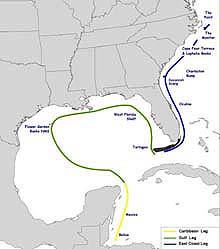
Route map for the Islands in the Stream Expedition. Click image for a larger view.
Mission Plan
Islands in the Stream is a three-month scientific expedition to marine protected areas and other habitats being considered for protection from offshore of Belize in Central America to North Carolina’s continental shelf. "Islands” are the coral reefs and hard-bottom (also called “hard substrate”) biological communities found along the course of a massive “stream” of ocean currents connecting the Caribbean Sea, the Gulf of Mexico, and the western Atlantic off North America. This expedition emphasizes habitat characterization and an understanding of these islands' "connection" as parts of an interrelated ecosystem. Though separated by large expanses of ocean water, the fishes, corals, and invertebrates common to these islands may demonstrate that the health and vitality of “downstream” islands are linked closely to those located “upstream." The expedition will be conducted in two major segments: The Caribbean and Gulf of Mexico Expedition (from Belize to the Dry Tortugas at the tip of the Florida Keys) and the South Altantic Bight Expedition (from Oculina Bank Reserve, off Florida’s Atlantic Coast, to three sites off the North Carolina continental shelf).
Caribbean Sea and Gulf of Mexico (Mid-May through Early July)
The first segment of the expedition was conducted as part of the Sustainable Seas Expedition, a five-year collaborative project between the National Ocean and Atmospheric Administration (NOAA) and the National Geographic Society. Sites visited during this segment of the expedition were:
- Offshore reefs of Belize and Mexico along the Yucatan Peninsula
- Flower Garden Banks National Marine Sanctuary off coastal Texas
- The Pinnacles, a series of deep-water reefs in the northern Gulf of Mexico
- Several sites along the West Florida continental shelf, including the Florida Middle Grounds and Pulley Ridge
- The Tortugas Ecological Reserve at the Florida Keys National Marine Sanctuary.
Biological community characteristics, including underlying geology and ecology, were studied at these sites, along with the current patterns that serve as the pathways for dispersing invertebrate larvae and the migratory routes of marine mammals, fish, and sea turtles. Oceanographic measurements helped researchers assess water-quality conditions entering and exiting marine protected areas. Expedition scientists explored deep reefs off the Yucatan Peninsula. They studied the growth and distribution of reefs at the Flower Garden Banks off Texas and assessed the influence of the Loop Current on habitats along the Pinnacle Reefs in the northern Gulf of Mexico. They also examined habitats on the West Florida Continental Shelf and at the recently designated Tortugas Ecological Reserve at the tip of the Florida Keys. The expedition provided an opportunity for the governments and scientific communities of Belize, Mexico, and the United States to work together, exploring and researching unique habitats and obtaining valuable information, such as digital video and still photography, water-quality data, oceanographic and atmospheric data, and more.
During this time, the NOAA Ship McArthur supported work in Belize, Mexico, and the Flower Garden Banks National Marine Sanctuary, while the NOAA Ship Gordon Gunter operated from the Pinnacles, in the northwestern Gulf of Mexico off Mississippi, to the Tortugas. Much of the underwater exploration was conducted using the DeepWorker 2000, a single-person submersible that can dive to 2,000 ft.
South Atlantic Bight (August 29 – September 29)
This segment of the expedition consists of five distinct legs or missions. They are:
- Leg 1 - Oculina Reserve (central Florida), August 29 – September 5
- Leg 2 - Savannah Scarp (Georgia), September 7 – 9
- Leg 3 - The Monitor National Marine Sanctuary (North Carolina), September 11 – 16
- Leg 4 - North Carolina Continental Shelf, September 19 – 26
- Leg 5 - Charleston Bump (South Carolina and Georgia), September 27 – 29
The South Atlantic Bight Expedition of Islands in the Stream is a cooperative venture between the National Oceanic and Atmospheric Administration, the Harbor Branch Oceanographic Institution (HBOI) of Fort Pierce, FL, and numerous state agencies and university scientists. The expedition will use a variety of technologies, including HBOI’s multiperson submersibles, the Clelia and the Johnson SeaLink, as well as its oceanographic vessel, Seward Johnson II.
Mission Objectives
The South Atlantic Bight Expedition will explore and characterize connections between physical environments and biological resources in protected and unprotected habitat areas. In addition, it will include a significant cultural component, and will attempt to collect information and samples useful for biomedical research. Teams of scientists and educators from several different institutions will focus on the following objectives, specific to the areas to be visited:
Research
- Explore and characterize deep coral banks in established or proposed marine protected areas
- Conduct studies on coral health and growth, and identify sources of mortality
- Conduct fish population censuses
- Assess how habitat functions as refuge for marine life, especially commercial fish species and their prey
- Assess how certain habitats function as spawning areas for fish species
- Determine how bank habitat and productivity compare in and outside of marine protected areas
- Recover artifacts from the wreck of the USS Monitor, and conduct detailed site surveys in preparation for next year's recovery efforts
Management
- Meet site-related information needs
- Increase opportunities for collaboration between scientists
- Increase communication between scientists and managers
- Increase communication between managers at all levels (inter- and intra-agency)
- Provide an opportunity to apply data to management decisions.
Outreach and Education
- Increase public understanding of the state of marine resources, the pressures they are under, and management responses
- Increase public awareness of the influences that human behavior has on habitats and resources
- Increase public understanding of the role of marine protected areas
- Convey research results to the public through aquariums and the Web
- Provide educational opportunities for secondary, middle and high school teachers and students.
Major activities to be conducted during each of the five missions of the South Atlantic Bight expedition, and background on each of the areas to be visited, are summarized below.
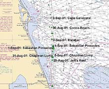
Proposed itinerary and dive locations for the Oculina Bank Reserve leg. Click image for a larger view.
Leg One: Characterizing the Oculina Bank Research Reserve
Oculina Bank, situated 30 km (18 mi) east of the northern Florida coast, was the first deep-water site in federal waters off the U.S. Eastern Seaboard to be closed to fishing. Once, this area was covered with dense thickets of the ivory tree coral, Oculina varicosa, which provided excellent habitat for reef fish, such as grouper and wreckfish, and feeding grounds for migratory pelagic (deep-sea) species. However, fishing activities destroyed approximately two-thirds of the bank. A fragile and slow-growing coral, deep-water Oculina only grows about one--half inch per year. These and other damaged coral reefs will take many years, even decades, to recover. To aid in the recovery process, a significant portion of the area was closed to fishing in 1994. NOAA has since funded efforts to assess the banks and to attempt to restore the damaged areas. In July 2000, the National Marine Fisheries Service approved plans to expand the protected area, with the goal of saving the remaining ivory tree coral. Much of the protected area is deeper than 100 m (328 ft), rugged, and can only be studied using advanced undersea technologies. The mission will use the HBOI submersible Clelia and an ROV to study the recovery of the reserve. In addition to habitat characterization work, visual observations of artificial-reef restoration structures deployed on the banks beginning in 1995 will help to determine species' rates of recruitment. Scientists will also test a hydrophone array to determine its utility for monitoring grouper spawning.
Leg Two: Distribution and Abundance of Fish Species at Savannah Scarp
Deep coral banks and areas of rocky outcrops occur all along the continental shelf edge, from northern Florida to Cape Hatteras, at depths of 100 to 500 m (328 to 1,640 ft) and at colorfully named places such as Pinkie Pa, Sow Pen, and Pig's Ear. Many of these banks, which are popular fishing grounds for commercial fishers, lie under the Gulf Stream or are routinely bathed by its west wall, eddies and filaments. Preliminary expeditions have explored some of these areas, but in general, little is known about their distributions and associated biology, and especially little about the resident fish populations.
This leg of the mission, led by Gray’s Reef National Marine Sanctuary, will provide useful information for comparing the Savannah Scarp to similar structures occurring within the sanctuary boundaries. For three days in September 2001, the team will explore these outcrops, and assess how they influence the development of coral and hard-bottom communities. The team also will study the combined effects of the habitat and the currents on the distribution and abundance of fish species. This leg will include the first submersible dives ever to take place here.
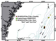
Locator map of Savannah Scarp. Click image for a larger view.
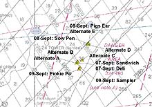
Proposed itinerary and dive locations for the Savannah Scarp leg. Click image for a larger view. Click image for larger view.
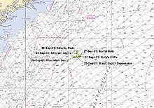
Leg Three: Submerged Cultural Resources at the Monitor National Marine Sanctuary
The first U.S. National Marine Sanctuary was established 32 km (approx. 20 mi) off Cape Hatteras, NC, at the wreck site of the USS Monitor, a Civil War ironclad vessel. The wreck has deteriorated rapidly in recent years. While the 73-m (240 ft) depth and strong currents make diving difficult at the wreck site, the sanctuary has been working for the past two summers with the U.S. Navy, using sophisticated scuba-diving techniques, to stabilize the wreck and to recover important artifacts. On July 16, 2001, the team recovered the 30-ton steam engine. Leg 3 of the IIS/South Atlantic Bight Mission will be conducted near the site for six days in mid-September 2001, after the scheduled stabilization and recovery work has concluded. Using the HBOI submersible Clelia, marine archeologists will survey the completed work and collect information to help plan next year’s efforts. In addition, this mission will provide an opportunity for supporters of the Monitor National Marine Sanctuary and members of the media to visit the wreck. Specific tasks include collecting digital video of the Monitor and collecting artifacts that may be scattered nearby.
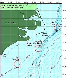
Leg Four: The North Carolina Continental Shelf (The Point, Lophelia Reefs, and Cape Fear Terrace)
The North Carolina Shelf consists of a wide range of habitats, many of which are rarely, if ever, visited. The existing data, however, indicate that the shelf includes numerous high-relief outcrops, paleo (ancient) reefs and shorelines, and potentially extensive hard-bottom communities, all of which typically support a variety of commercially important and unique fish species. Because the data is scarce, scientists have a limited understanding of the shelf's habitats, species distribution, and ecological function, even though it is heavily used by commercial and recreational fishers as well as commercial shipping traffic. The effects of these activities on shelf habitats are virtually unknown.
Proposed itinerary and dive locations for the North Carolina Continental Shelf leg. Click image for a larger view.
This leg of the IIS/South Atlantic Bight Mission will target three distinct systems. For two days, the HBOI submersible Johnson-Sea-Link will explore a unique continental-shelf canyon system at "the Point." The southernmost Mid-Atlantic canyon system, the Point has distinctive benthic (bottom-dwelling) habitats and fish assemblages, which may be influenced by the unique and ever-changing patterns of currents and gyres there. At this spot, colder, nutrient-laden coastal waters from Virginia flow south along the coast, "bounce" off of Cape Hatteras, and collide with warmer, Gulf Stream waters. The result is a "hot spot" of productivity, from seabirds in the air to plankton and giant bluefin tuna in the sea. Scientists will document conditions from the canyon heads to depths greater than 600 m (1,970 ft).
Next, scientists will spend four days studying the ecology and community structure of fish and macroinvertebrates at the Lophelia Banks, an extensive system of deep-water corals (Lophelia and Denrophelia) existing below the Gulf Stream. They hope to add to the very limited collections of specimens from the banks, and gain enough information to begin to describe the numbers and types of species, their distributions, and their habitat associations.
This leg will conclude with two days of exploration at the Cape Fear Terrace, an extensive area of hard-bottom communities that may support a well-developed, diverse community of subtropical fish and benthic species. Most of the existing data for this area has been collected for selected fisheries species. The IIS/South Atlantic Bight Mission is one of few ever conducted here that is independent of fisheries. Because time is limited, scientists hope that the data obtained will set the stage for additional work in the future.
Leg Five: Visual Observations and Biota Samples at Charleston Bump
The Gulf Stream encounters the Charleston Bump at the South Carolina-Georgia border. The Bump is a highly productive ecosystem, in part because it interacts with the Gulf Stream, and is now being considered for marine protected status. The feature is one of the most popular fishing grounds in the South Atlantic Bight, and provides both spawning and nursery habitat for many species. The Bump essentially causes the Gulf Stream to "break up," much like a large rock in a river. Consequently, water upwells to form large, cyclonic eddies and filaments downstream (north) of the Bump. The eddies are a crucial mechanism for the transport of reef fish to shelf environments off the Carolinas.
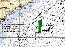
Locator map of Charleston Bump. Click image for a larger view.
Proposed itinerary and dive locations for the Charleston Bump leg. Click image for a larger view.
The IIS/South Atlantic Bight Mission will conclude at the end of September with three days of operations in the vicinity of the Charleston Bump. Scientists will complement visual observations with specimens to understand more about the distribution of juvenile stages of commercially important pelagic species. Oceanographic observations, including CTD (conductivity, temperature, depth) and ADCP (Acoustic Doppler Current Profiler), will help describe this highly dynamic environment.
Partnerships
The success of this expedition relies upon partnerships, which provide an opportunity for scientists, natural resource managers, and educators from many public and private agencies and institutions to collaborate on a common set of goals and objectives. The following is a list of some of the institutions engaged in this endeavor:
Florida State University Department of Biological Science
Harbor Branch Oceanographic Institute
National Aeronautic and Space Administration
National Geographic Society
NOAA, National Ocean Service, Office of National Marine Sanctuaries
NOAA, National Ocean Service, Special Projects Office
NOAA, Office of Oceanic and Atmospheric Research, National Undersea Research Program, University of North Carolina at Wilmington
NOAA, Ocean Exploration Office
NOAA, National Marine Fisheries Service
North Carolina National Estuarine Research Reserve
South Carolina Marine Resources Institute
United States Geological Survey
Sign up for the Ocean Explorer E-mail Update List.