


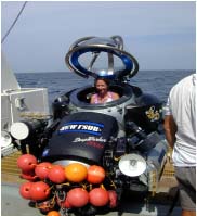
Emma Hickerson, science coordinator for the Flower Gardens National Marine Sanctuary, prepares to conduct transects in the Madison Swanson Marine Fishery Reserve in the DeepWorker submersible. (Photo courtesy of Doug Weaver)
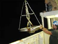
The Van Veen grab sediment sampler being deployed from the NOAA Ship Gordon Gunter. (Photo courtesy of Kathryn Scanlon, USGS)
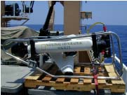
ROVs (remotely operated vehicles) are useful for visual characterization of benthic habitats. (Photo courtesy of Doug Weaver)
A Preliminary Report on the West Florida Shelf
June 12-25 , 2001
Felicia Coleman, Program Director
Institute for Fishery Resource Ecology
Florida State University
From June 12 through 25, 2001, a team of collaborating scientists gathered on the NOAA Ship Gordon Gunter to survey portions of the continental shelf edge of the northeastern Gulf of Mexico. Their primary interests are the sites that reef fish use as focal points for spawning. An ancillary project of shorter duration involved a search for signs of drowned riverbeds (extensions of the primary rivers of the peninsular West Coast of Florida). The intent was to find offshore signs of human habitation, which would be consistent with the much lower sea levels of the Pleistocene era. Unexpected problems with the availability of critical bottom-viewing gear constrained the primary mission of this leg, cutting the available work time in half. In spite of this drawback, the team successfully completed preliminary surveys of important features in most of the originally planned sites, and still found time to evaluate two undescribed areas.
Our primary research tools include submersibles, remotely operated vehicles (ROVs), and a sediment-sampling apparatus known as a Van Veen grab. The submersible allows a person to descend to the bottom and view it directly. An ROV does not, yet it has important advantages in that it can operate in higher (e.g., rougher, windier) sea states than the sub, it is very easily deployed, and it is free of the safety concerns associated with putting people on the sea floor. The ROV operator remains on the ship and uses a joystick, much like that found on video games, to move the ROV across the bottom. The operator can "see" through the ROV's video "eyes," and can determine where the ROV is going with a tracking device. The major disadvantage is that the ROV must be tethered to the ship by an umbilical cable to allow the shipboard operator this view of the bottom. It also gives the operator a much more limited field of view than that afforded by the sub. The Van Veen grab is used to collect sediment samples from the ocean floor. Geologists use these samples to verify the bottom composition of their acoustically produced sea-floor images.
Regardless of the gear used, scientists must randomly sample the habitat and not favor one spot over another. For instance, the tendency for the novice would be to concentrate on areas that have high relief, because they appear to be more spectacular. It turns out that reef fish, particularly the large ones that support commercial and recreational fisheries, do not necessarily share this viewpoint. In fact, some of the more diverse and interesting habitats encountered during this leg of the mission were found in low-relief sites, and some in sites that barely registered on fathometers (standard shipboard instruments used to determine differences in depth along the bottom).
Documentation of the habitat occurs with the use of video cameras. In this case, we used two video cameras -- a forward-looking one to capture the habitats and associated fish species, and a downward-looking one to capture the composition of the bottom. By piecing together videotapes from these cameras, we can get a fairly good idea of the composition of benthic communities, including both the sessile creatures that are stuck steadfastly to the bottom, and the mobile organisms that move in and out of the area.
In addition, the cameras operate in conjunction with a system of laser lights with parallel and converging beams. These laser systems allow us to determine distances and to measure the size of organisms and the size of the area of view. Such measurements are crucial in characterizations because without them, one has no perspective on the size of the creatures or the areas being viewed. Small organisms appear large in closeup view, and large ones appear small at a distance. Mosaics of the sea-floor habitat require the laser-derived perspective of the size of the videotaped areas.
Photomosaics of the habitat are constructed from video images and superimposed on the acoustically produced geomorphological maps to produce a composite picture of the sea-floor habitat. The production of these mosaics and the quantification of habitat features are time-consuming processes that will take months to complete and will involve additional scientific cruises to these study sites. Thus, the information gained from each site is very preliminary and will be built upon in the coming years.
For characterizations of the dive sites, visit the pages below:
The Pinnacles
West Florida Shelf
The research team included marine scientists from the Institute for Fishery Resource Ecology, a collaborative research program between Florida State University (FSU) and the National Marine Fisheries Service (NMFS Southeast Region), as well as fishery ecologists from FSU and the University of Florida, a benthic ecologist from NMFS (Miami), a geologist from the U.S. Geological Survey (USGS, Woods Hole, MA), and a marine anthropologist from FSU. Significant onboard support came from the Flower Gardens National Marine Sanctuary scientists, and shore-based support came from NMFS scientists associated with laboratories in Pascagoula, MS, and Panama City, FL. The surveys conducted during this leg of the Sustainable Seas Expeditions/Islands in the Stream cruise represent only part of an ongoing collaboration between FSU, NMFS, and the USGS to evaluate the efficacy of using marine protected areas, particularly marine reserves, for fisheries of the southeastern United States.
Sign up for the Ocean Explorer E-mail Update List.